25th Annual Black Diamond Fall Fundraising Party
Thursday, September 13; 6:00-10:00 PM; Black Diamond Parking Lot
25th Annual Black Diamond Fall Fundraising Party
Thursday, September 13; 6:00-10:00 PM; Black Diamond Parking Lot
| Advisory: Uintas Area Mountains | Issued by Craig Gordon for Tuesday - January 3, 2017 - 3:31am |
|---|

|
bottom line HEADS UP- The avalanche danger will be rising late this afternoon and may reach HIGH by days end. In upper elevation terrain, particularly leeward slopes in the wind zone, at and above treeline, a CONSIDERABLE avalanche danger exists. Human triggered avalanches are LIKELY on steep, wind drifted slopes, especially those facing the north half of the compass, and particularly those with an easterly component to their aspect. Once triggered, today's avalanches have the potential to break much deeper and wider than you might expect. You'll find a MODERATE avalanche danger on steep wind drifted slopes at mid elevations and human triggered avalanches are possible. Out of the wind, our snowpack is well behaved and predictable and the avalanche danger is LOW
|
 |
special announcement Give the gift that keeps giving and help save a life by doing so. Sign up for one of our Riding Skills and Avy Awareness Workshops given by sledders... for sledders. We've got two workshops this year- Thursday Jan 19th evening, followed by an on the snow field day Saturday Jan. 21st. Details here. Thursday Feb. 9th evening, followed by an on the snow field day Saturday Feb. 11th. Details here. |
 |
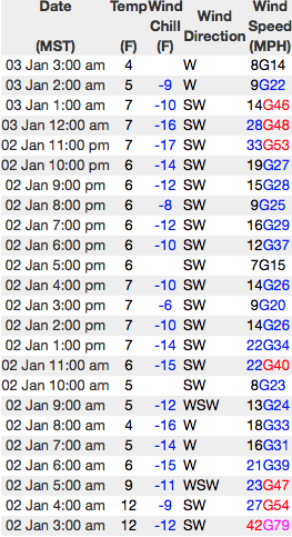
current conditions Wow... what a great way to ring in the New Year! While the Uinta's were a little late to the powder party the range make up for lost time once it arrived, quickly stacking up 14" of light, fluffy, blower powder. Under mostly cloudy skies, a flurry or two still lingers. Temperatures are in the low teens and as of 3:00 AM, winds are pretty well-behaved (see below). On a go-anywhere base riding and turning conditions are epically deep. It's an over-the-hood and over-the head, call in sick kinda day.
The data above is a 24 hour run from Lofty and Windy Peaks. Real time wind, snow, and temperatures for the Uinta's are found here. Snowpack observations and trip reports are found here. |
 |
recent activity Very sensitive soft slabs were easily triggered on steep, leeward slopes during the height of yesterday's storm. Most notable was a slope cut on a 38 degree, northeast facing slope, that produced a new snow slide approximately 14" deep, 200' wide, running 400' vertically, and packed a healthy punch. A full list of recent Uinta avalanche activity is found here. |
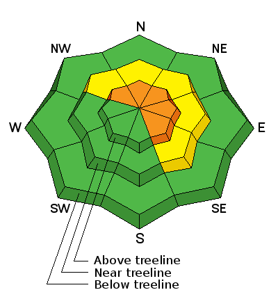
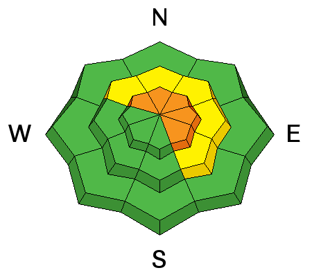
| type | aspect/elevation | characteristics |
|---|

|
|
LIKELIHOOD
 LIKELY
UNLIKELY
SIZE
 LARGE
SMALL
TREND
 INCREASING DANGER
SAME
DECREASING DANGER
|
|
description
Yesterday mornings manageable new snow avalanches, bulked up as the day wore on and today you'll find a burlier, more powerful version, and they'll be packing a solid punch. Sensitive to our additional weight and breaking above or even adjacent to the slope we're riding, yesterday's wind slabs are now covered over with fresh snow, making them hard to detect. So the best offense of course, is a good defense. With all the good riding out there, simply steer clear of steep, wind drifted terrain and be on the look out for and avoid any round, fat, pillows of snow. In addition, gather some BETA during your travels. Tweak a couple of road cuts and see how they're reacting and take that information to help you decide where to ride safely today. Any increase in wind speeds today will quickly bump the danger rating into the HIGH category.
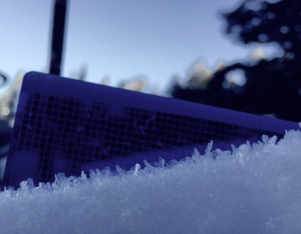
All of our new storm snow rests on a fragile weak layer similar to the one pictured above. |
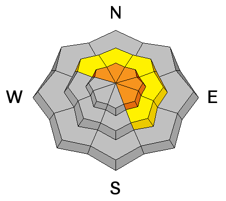
| type | aspect/elevation | characteristics |
|---|

|
|
LIKELIHOOD
 LIKELY
UNLIKELY
SIZE
 LARGE
SMALL
TREND
INCREASING DANGER
SAME
DECREASING DANGER
|
|
description
I don't think we've added enough water weight to activate the dormant weak layers buried deep in our pack, but it's definately not a good time to become complacent thinking all we're dealing with are new snow avalanches. Steep, rocky, upper elevation slopes facing the north half of the compass should still be considered suspect. If you're getting into complex terrain like steep, upper elevation, north facing bowls and chutes, think of the worst case scenario and at the very least, have an exit strategy ready to pull out of the queue.
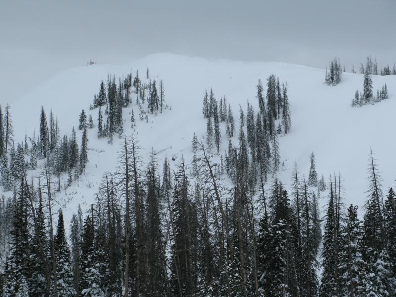
When I think of a place that harbors weak snow and the potential to trigger a deep, dangerous avalanche, Currant Creek Peak always comes to mind. We took a spin out there earlier last week and found mostly supportable snow and a solid snowpack. But with all the great riding options available, there's no reason to tease this slope and roll the dice... this is exactly the type of complex terrain I'd steer clear of. |
 |
weather Lingering snow showers bring another inch or two to our region this morning, but in general this portion of the storm is winding down. Skies remain mostly cloudy and high temperatures climb into the mid 20's. Snow and wind ramp back up during the latter half of tonight and continue through tomorrow as another good shot of snow sets it's sites on the range Wednesday night and Thursday morning. |
| general announcements Remember your information can save lives. If you see anything we should know about, please participate in the creation of our own community avalanche advisory by submitting snow and avalanche conditions. You can call me directly at 801-231-2170, email [email protected] The information in this advisory is from the US Forest Service which is solely responsible for its content. This advisory describes general avalanche conditions and local variations always occur. The information in this advisory expires 24 hours after the date and time posted, but will be updated by 7:00 AM on Wednesday January 4th. |