25th Annual Black Diamond Fall Fundraising Party
Thursday, September 13; 6:00-10:00 PM; Black Diamond Parking Lot
25th Annual Black Diamond Fall Fundraising Party
Thursday, September 13; 6:00-10:00 PM; Black Diamond Parking Lot
| Advisory: Uintas Area Mountains | Issued by Craig Gordon for Thursday - December 8, 2016 - 3:49am |
|---|

|
bottom line At mid and upper elevations, especially in the wind zone, the avalanche danger is MODERATE this morning and human triggered avalanches are possible on steep, wind drifted slopes, particularly in terrain with an easterly component to its aspect. With a good shot of snow and wind forecast the danger may rise to CONSIDERABLE with human triggered avalanches likely by days end. The avalanche danger in wind sheltered terrain and on low elevation slopes is generally LOW.
|
 |
special announcement The big news is... an active weather pattern is headed our way. This is going to change the relatively benign avalanche conditions we've been enjoying. Our partners at the National Weather Service put together a great video briefing found here Heads up- Plowing operations have ceased for Mirror Lake Highway. Wolf Creek Pass is still mostly pavement and access to avalanche terrain is relatively easy. Remember... just cause you can see your rig from a ridgeline doesn't necessarily make the terrain any safer and triggering even a small slide this time of year will reveal stumps, rocks, and general nastiness, easily ruining your day or perhaps your season.
|
 |
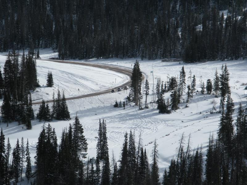
current conditions Skies cleared out last night and temperatures crashed into negative territory where they sit this morning. Most stations are hovering right around -5 degrees and with southwest winds in the 20's along the high ridges, wind chill values are right around -20 degrees. Real time wind, snow, and temperatures for the Uinta's are found here. Recent observations are found here.
|
 |
recent activity No recent avalanche activity to report. |
| type | aspect/elevation | characteristics |
|---|

|
|
LIKELIHOOD
 LIKELY
UNLIKELY
SIZE
 LARGE
SMALL
TREND
 INCREASING DANGER
SAME
DECREASING DANGER
|
|
description
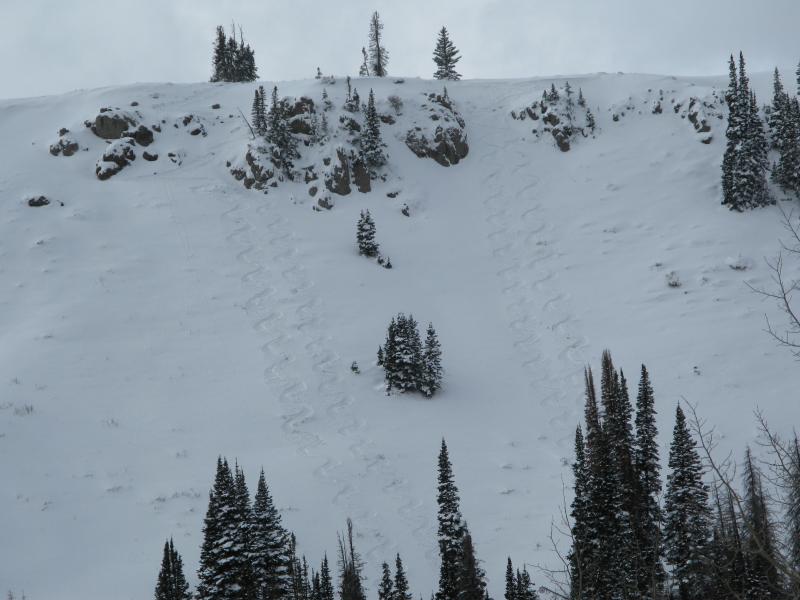
Winds increase throughout the day, snow develops this afternoon and yep you guessed it... it'll be a day of rising avalanche danger. I think this morning it's pretty straightforward and we're dealing with a few tired wind slabs along the leeward side of upper elevation ridges. However, once the storm settles in and there's some snow for the winds to work with, I bet fresh drifts become more widespread and more sensitive to the additional weight of a person. Easy to detect by their fat, rounded, chalky appearance, by days end these slabs may break wider and deeper than you might expect. And remember- snow cover remains thin and any slide triggered today has the possibility of breaking into older snow near the ground. That combo will reveal stumps, rocks, or deadfall, resulting in an unexpected and possibly traumatic ride.
This is a good looking Uinta snowpack... in general, well-behaved and homogenous. Consistent 4 finger layering throughout with a little wind skin/slab topping off the snow surface. The upcoming storm is going to put our pack to the test. |
 |
weather A good shot of snow develops late today and lingers into Saturday. Look for increasing clouds, highs in the low 20's, with snow beginning around dinner time. Westerly winds ramp up and blow in the 30's and 40's by days end. The storm kicks in overnight and 8"-10" of snow looks like a good bet by Friday morning. A break in the action is slated for Friday with another round of snow expected late in the day. |
| general announcements Remember your information can save lives. If you see anything we should know about, please participate in the creation of our own community avalanche advisory by submitting snow and avalanche conditions. You can call me directly at 801-231-2170, email [email protected] The information in this advisory is from the US Forest Service which is solely responsible for its content. This advisory describes general avalanche conditions and local variations always occur. The information in this advisory expires 24 hours after the date and time posted, but will be updated on Friday December 9th. |