25th Annual Black Diamond Fall Fundraising Party
Thursday, September 13; 6:00-10:00 PM; Black Diamond Parking Lot
25th Annual Black Diamond Fall Fundraising Party
Thursday, September 13; 6:00-10:00 PM; Black Diamond Parking Lot
| Advisory: Uintas Area Mountains | Issued by Craig Gordon for Wednesday - November 30, 2016 - 3:53am |
|---|

|
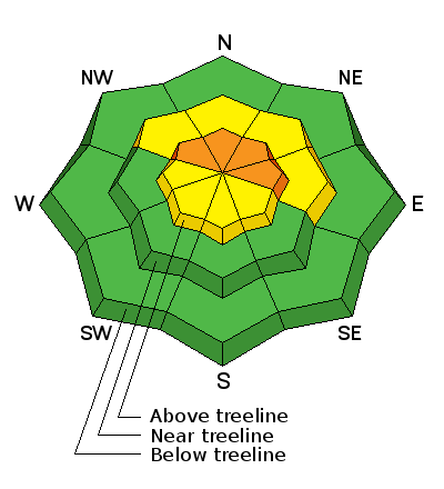
bottom line In the wind zone, at and above treeline, the avalanche danger is CONSIDERABLE today. Human triggered avalanches are likely, especially on steep, wind drifted, shady slopes facing the north half of the compass. Any avalanche breaking into old snow will be deep and dangerous. At mid elevations you'll find MODERATE avalanche danger and human triggered avalanches are possible on steep slopes with recent deposits of wind drifted snow. The avalanche danger on low elevation slopes is generally LOW.
|
 |
special announcement
Heads up- Plowing operations have ceased for Mirror Lake Highway. Wolf Creek Pass is snowpacked and access to avalanche terrain is relatively easy. Remember... just cause you can see your rig from a ridgeline doesn't necessarily make the terrain any safer and triggering even a small slide this time of year will reveal stumps, rocks, and general nastiness, easily ruining your day or perhaps your season. |
 |
current conditions Lingering clouds over the range delivered another 3"-5" of light density, cold smoke yesterday afternoon, bumping storms totals to just over 24". Northeast winds gusted into the 20's and 30's along the high peaks, but mellowed out midday and are currently in the 5-15 mph range. Temperatures are in the single digits with a couple stations still in negative territory. Total snow depths are in the 24"-36" range and it's starting to look like winter out there! Real time wind, snow, and temperatures for the Uinta's are found here. |
 |
recent activity Visibility has been limited throughout the storm, so no new avalanche activity to report. |
| type | aspect/elevation | characteristics |
|---|

|
|
LIKELIHOOD
 LIKELY
UNLIKELY
SIZE
 LARGE
SMALL
TREND
 INCREASING DANGER
SAME
DECREASING DANGER
|
|
description
The multi-day storm formed fresh wind drifts all over the place, especially along the leeward side of upper elevation ridges and around terrain features like chutes and gullies. Fat and rounded in their appearance, today's wind drifts might not be quite as reactive as the past few days, but still have the possibility to break deeper and wider than you expect. Remember... snow cover remains thin and any slide triggered today has the possibility to uncover stumps, rocks, or deadfall, resulting in an unexpected and traumatic ride. |
| type | aspect/elevation | characteristics |
|---|

|

|
LIKELIHOOD
LIKELY
UNLIKELY
SIZE
 LARGE
SMALL
TREND
INCREASING DANGER
SAME
DECREASING DANGER
|
|
description
In general, we're off to a good start in the Uinta's and our weak snow issues are isolated to a handful of upper elevation slopes facing the north half of the compass... think of places like Murdock Bowl which retained snow from late September. While making up a small portion of the terrain available to ride in, if your travels take you into steep, upper elevation, north facing terrain, remember that any avalanche you trigger has the possibility of breaking into old snow, creating a deep, dangerous slide. With all the great riding out there why even pull on the dogs tail? Practice some patience, avoid those slopes, and carve deep trenches on low angle slopes or head to the sunny aspects that had no snow prior to the big storm. |
 |
weather Today we can expect partly cloudy skies, temperatures barely rising into the low teens, and northwest winds blowing 15-25 mph along the high peaks. A weak system approaches tonight, then gradually moves across Utah from north to south through Friday morning. Expect periods of light snow, continued cold temperatures, and ridgetop winds remaining well behaved and in the 10-25 mph range. |
| general announcements Remember your information can save lives. If you see anything we should know about, please participate in the creation of our own community avalanche advisory by submitting snow and avalanche conditions. You can call me directly at 801-231-2170, email [email protected] The information in this advisory is from the US Forest Service which is solely responsible for its content. This advisory describes general avalanche conditions and local variations always occur. The information in this advisory expires 24 hours after the date and time posted, but will be updated on Thursday December 1st. |


