25th Annual Black Diamond Fall Fundraising Party
Thursday, September 13; 6:00-10:00 PM; Black Diamond Parking Lot
25th Annual Black Diamond Fall Fundraising Party
Thursday, September 13; 6:00-10:00 PM; Black Diamond Parking Lot
| Advisory: Skyline Area Mountains | Issued by Brett Kobernik for Sunday - April 8, 2018 - 6:30am |
|---|

|
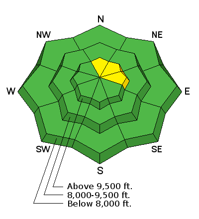
bottom line The overall avalanche danger is generally LOW today. I would avoid being on steep slopes or steep gullies in the mid elevations where the snowpack is totally wet and saturated. I am also still a little suspect of the steepest high elevation north through east facing slopes that still hold weak snow near the ground.
|
 |
special announcement THIS IS THE LAST WEEKEND FOR REGULAR AVALANCHE FORECASTING FOR THE MANTI SKYLINE |
 |
current conditions After a warm rainy day in the mountains on Saturday, temperatures cooled off overnight down into the upper 20s. This will have frozen up the wet snow surface and we'll most likely find a slick frozen rain crust on the surface in the higher elevations this morning. The shallow snow in the mid elevations may still be wet and saturated. We may find a small amount of dense new snow that fell overnight at the highest locations but it won't be much if any. The wind became quite strong overnight from the northwest but has backed off this morning. |
 |
recent activity I don't think conditions were right for any significant wet avalanche activity on Saturday. I don't think enough rain fell to really affect the weak snow deep in the snowpack. I'll have a look around today to confirm this. |
| type | aspect/elevation | characteristics |
|---|

|
|
LIKELIHOOD
 LIKELY
UNLIKELY
SIZE
 LARGE
SMALL
TREND
 INCREASING DANGER
SAME
DECREASING DANGER
|
|
description
I'm not expecting dangerous avalanche conditions today. Cooler temperatures will help lock up the snowpack at least in the higher terrain. Continue to pay attention to conditions if you're heading out today. There is hardly enough snow in the mid elevations to recreate on but if for some reason you're in that terrain and you're finding it very wet and unsupportable, I'd stay away from steep slopes and gullies. |
 |
weather The storm has moved out and we'll see partly cloudy skies with breezy ridge top wind from the northwest. Ridge top high temperatures will be around 30. We'll see a warming trend through mid week with mostly clear skies. A colder storm is shaping up for later in the week that looks like it will bring some snow. |
| general announcements Support the Utah Avalanche Center through your everyday shopping. DETAILS HERE We will publish full detailed advisories Saturday and Sunday mornings by 7am. We will also be publishing basic avalanche danger ratings & info during the week. If you are getting out into the mountains, we love to hear from you! You can SUBMIT OBSERVATIONS ONLINE or EMAIL US If you would like to have avalanche advisories emailed to you, SIGN UP HERE We can provide basic avalanche awareness presentations for your school, group or club. To enquire, CLICK HERE |


