25th Annual Black Diamond Fall Fundraising Party
Thursday, September 13; 6:00-10:00 PM; Black Diamond Parking Lot
25th Annual Black Diamond Fall Fundraising Party
Thursday, September 13; 6:00-10:00 PM; Black Diamond Parking Lot
| Advisory: Skyline Area Mountains | Issued by Brett Kobernik for Monday - April 2, 2018 - 6:53am |
|---|

|
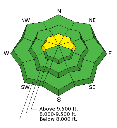
bottom line Most of the terrain along the Skyline has a LOW to MODERATE avalanche danger. There is a remote chance that a person could trigger an avalanche that breaks to the ground on slopes approaching 40 degrees in steepness that face north through east above about 9500' in elevation. If you avoid this terrain you will avoid avalanche danger.
|
 |
current conditions |
 |
weather Monday: A 40 percent chance of snow showers after noon. Mostly sunny, with a high near 36. Windy, with a west wind 14 to 24 mph increasing to 34 to 44 mph in the afternoon. Winds could gust as high as 60 mph. New snow accumulation of less than one inch possible. |
| general announcements Support the Utah Avalanche Center through your everyday shopping. DETAILS HERE We will publish full detailed advisories Saturday and Sunday mornings by 7am. We will also be publishing basic avalanche danger ratings & info during the week. If you are getting out into the mountains, we love to hear from you! You can SUBMIT OBSERVATIONS ONLINE or EMAIL US If you would like to have avalanche advisories emailed to you, SIGN UP HERE We can provide basic avalanche awareness presentations for your school, group or club. To enquire, CLICK HERE |


