25th Annual Black Diamond Fall Fundraising Party
Thursday, September 13; 6:00-10:00 PM; Black Diamond Parking Lot
25th Annual Black Diamond Fall Fundraising Party
Thursday, September 13; 6:00-10:00 PM; Black Diamond Parking Lot
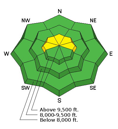
| Advisory: Skyline Area Mountains | Issued by Brett Kobernik for Sunday - April 1, 2018 - 6:46am |
|---|

|
bottom line The majority of the terrain along the Skyline has a LOW to MODERATE danger. There is still a small chance that a person could trigger an avalanche that breaks to the ground in the upper elevation terrain. North through east facing slopes that are approaching 40 degrees in steepness are the most suspect. It seems fairly unlikely that someone will trigger something but the consequences would be bad if you do.
|
 |
current conditions Warm temperatures over the last few days have made most slopes become wet and you'll find a melt-freeze crust on them this morning until they soften. Even most of the high elevation northerly slopes have been effected by the warm temperatures. Overnight mountain temperatures remained fairly warm with lows in the low to mid 30s. West wind picked up a bit and it's been a bit blustery overnight. |
| type | aspect/elevation | characteristics |
|---|

|
|
LIKELIHOOD
 LIKELY
UNLIKELY
SIZE
 LARGE
SMALL
TREND
 INCREASING DANGER
SAME
DECREASING DANGER
|
|
description
I have covered lots of terrain along the Skyline over the last few days evaluating the overall strength of the snowpack. What I've come up with is that the weak snow near the ground is certainly still there but the mid portion of the pack is quite strong now. My take is that it is fairly unlikely that a person will effect the deeply buried weak layers through the strong mid snowpack. Do I like this set up? No way! It makes me nervous but things are becoming more stable. If you are getting onto the steeper upper elevation northerly facing slopes, I would avoid shallow spots where bushes or rocks are sticking through the snowpack. These are likely spots to trigger something that breaks to the ground. The deeper areas are the most stable. |
 |
weather We'll have another day of mild temperatures in the hills with moderate speed ridge top west wind. Highs will be in the low 40s again. West northwest wind will be in the moderate speed range. It'll feel a bit gusty along the higher ridges. The big picture is we'll see continued warm weather for the most part with a few minor weather disturbances this week. A slightly larger storm is shaping up for next weekend but it's looking less impressive than is originally did. More warm weather follows. |
| general announcements Support the Utah Avalanche Center through your everyday shopping. DETAILS HERE We will publish full detailed advisories Saturday and Sunday mornings by 7am. We will also be publishing basic avalanche danger ratings & info during the week. If you are getting out into the mountains, we love to hear from you! You can SUBMIT OBSERVATIONS ONLINE or EMAIL US If you would like to have avalanche advisories emailed to you, SIGN UP HERE We can provide basic avalanche awareness presentations for your school, group or club. To enquire, CLICK HERE |


