25th Annual Black Diamond Fall Fundraising Party
Thursday, September 13; 6:00-10:00 PM; Black Diamond Parking Lot
25th Annual Black Diamond Fall Fundraising Party
Thursday, September 13; 6:00-10:00 PM; Black Diamond Parking Lot
| Advisory: Skyline Area Mountains | Issued by Brett Kobernik for Friday - March 9, 2018 - 6:54am |
|---|

|
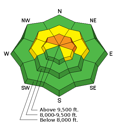
bottom line As the week goes on, the chance of triggering an avalanche becomes less but make no mistake that there is a very real possibility of triggering an avalanche that breaks to the ground. Likelihood is decreasing but consequence stays the same. The avalanche danger remains CONSIDERABLE in the upper elevation northwest through east facing steep slopes. Outside of this terrain, the avalanche danger is much lower and it is easy to travel around safely.
|
 |
recent activity |
 |
weather Issued by the National Weather Service: Friday: Mostly sunny, with a high near 35. West wind 10 to 15 mph. |
| general announcements Support the Utah Avalanche Center through your everyday shopping. DETAILS HERE We will publish full detailed advisories Saturday and Sunday mornings by 7am. We will also be publishing basic avalanche danger ratings & info during the week. If you are getting out into the mountains, we love to hear from you! You can SUBMIT OBSERVATIONS ONLINE or EMAIL US If you would like to have avalanche advisories emailed to you, SIGN UP HERE We can provide basic avalanche awareness presentations for your school, group or club. To enquire, CLICK HERE |


