25th Annual Black Diamond Fall Fundraising Party
Thursday, September 13; 6:00-10:00 PM; Black Diamond Parking Lot
25th Annual Black Diamond Fall Fundraising Party
Thursday, September 13; 6:00-10:00 PM; Black Diamond Parking Lot
| Advisory: Skyline Area Mountains | Issued by Brett Kobernik for Wednesday - February 28, 2018 - 7:17am |
|---|

|
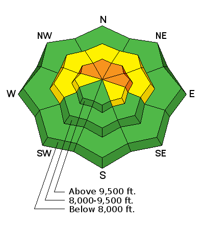
bottom line The avalanche danger remains CONSIDERABLE on steep slopes that face northwest, and especially north and east. This means human triggered avalanches are likely in this terrain again today. Outside of the terrain mentioned, the avalanche danger is much lower and you can travel safely.
|
 |
current conditions The mountains picked up a trace to an inch of snow early last night. Temperatures are in the mid teens and it looks like the ridge top west wind has increased a bit. The wind does not look like it is getting into the canyon bottoms. |
 |
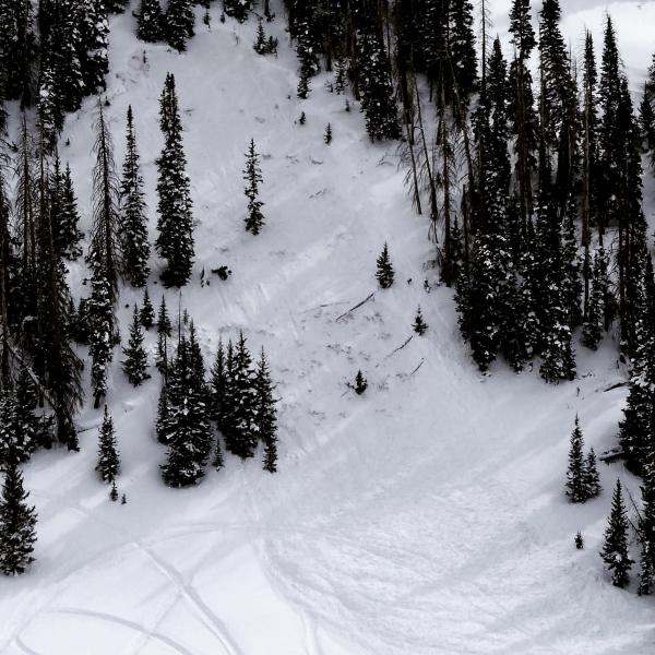
recent activity My partner and I came across this avalanche which most likely released on Sunday, Feb 25. It broke 2 to 3 feet deep into weak sugary faceted snow. It was no doubt triggered by a snowmobiler but no other info is known.
|
 |
weather Issued by the National Weather Service Today: Mostly sunny, with a high near 22. Wind chill values as low as -1. West wind 8 to 11 mph. |
| general announcements Support the Utah Avalanche Center through your everyday shopping. DETAILS HERE We will publish full detailed advisories Saturday and Sunday mornings by 7am. We will also be publishing basic avalanche danger ratings & info during the week. If you are getting out into the mountains, we love to hear from you! You can SUBMIT OBSERVATIONS ONLINE or EMAIL US If you would like to have avalanche advisories emailed to you, SIGN UP HERE We can provide basic avalanche awareness presentations for your school, group or club. To enquire, CLICK HERE |