25th Annual Black Diamond Fall Fundraising Party
Thursday, September 13; 6:00-10:00 PM; Black Diamond Parking Lot
25th Annual Black Diamond Fall Fundraising Party
Thursday, September 13; 6:00-10:00 PM; Black Diamond Parking Lot
| Advisory: Skyline Area Mountains | Issued by Brett Kobernik for Friday - February 16, 2018 - 6:58am |
|---|

|
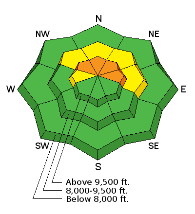
bottom line The avalanche danger is CONSIDERABLE on steep slopes above about 9500' in elevation that face northwest, north and east especially in areas that received the most new snow. High density new snow along with strong wind on top of a weak snowpack has increased the avalanche danger. This is becoming a tricky situation since you may not see obvious signs of danger such as other recent avalanches, cracking of the snowpack or collapsing of the snowpack (loud "whoomping" sounds). Human triggered avalanches are likely in the terrain mentioned above. The avalanche danger is much lower outside of this terrain.
|
 |
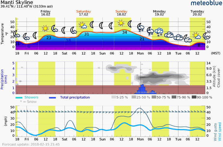
current conditions The recent storm wound down Thursday afternoon with an inch of snow or a bit more falling during the day. This brings snow totals up to 8 to 10 inches from about Pleasant Creek through Ephraim and Manti Canyons. Fairview Canyon and the southern end of the Skyline received less snow. The new snow is medium to high density. The wind was blowing fairly strong for most of the storm. For more details CHECK OUT THIS BACKCOUNTRY OBSERVATION FROM THURSDAY. |
 |
weather
|
| general announcements Support the Utah Avalanche Center through your everyday shopping. DETAILS HERE We will publish full detailed advisories Saturday and Sunday mornings by 7am. We will also be publishing basic avalanche danger ratings & info during the week. If you are getting out into the mountains, we love to hear from you! You can SUBMIT OBSERVATIONS ONLINE or EMAIL US If you would like to have avalanche advisories emailed to you, SIGN UP HERE We can provide basic avalanche awareness presentations for your school, group or club. To enquire, CLICK HERE |