25th Annual Black Diamond Fall Fundraising Party
Thursday, September 13; 6:00-10:00 PM; Black Diamond Parking Lot
25th Annual Black Diamond Fall Fundraising Party
Thursday, September 13; 6:00-10:00 PM; Black Diamond Parking Lot
| Advisory: Skyline Area Mountains | Issued by Brett Kobernik for Thursday - February 15, 2018 - 6:55am |
|---|

|
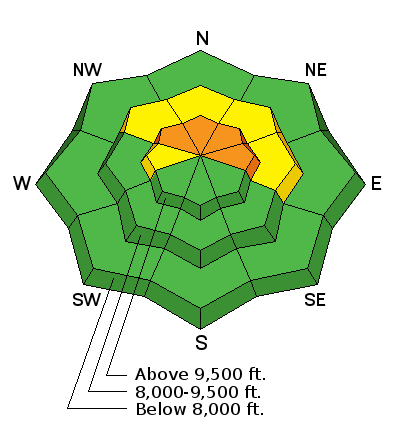
bottom line The avalanche danger is CONSIDERABLE on slopes steeper than 35˚ above 9500' that face northwest, north and east especially in areas that received the most new snow. New snow and wind drifted snow have added weight on top of the shallow weak snowpack. That said, things won't be super sensitive or "hair trigger". Some of these slopes may avalanche, some may not. This makes things quite tricky. Outside of the terrain mentioned above, the avalanche danger is much lower.
|
 |
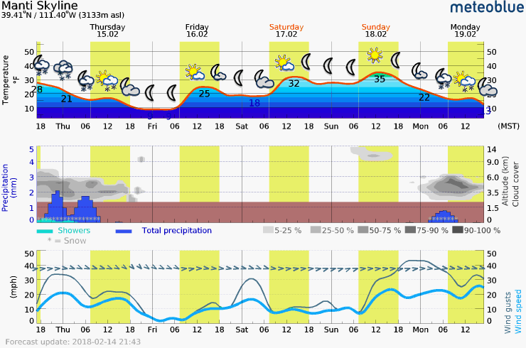
current conditions It looks like Ephraim Canyon was favored by the storm overnight picking up 9 inches of new snow. Fairview Canyon received about 4 inches. The southern end of the Skyline only picked up a few inches. West wind was strong but has been slowing over the last few hours. It's still a bit blustery. Mountain temperatures are in the upper teens. |
 |
weather
|
| general announcements Support the Utah Avalanche Center through your everyday shopping. DETAILS HERE We will publish full detailed advisories Saturday and Sunday mornings by 7am. We will also be publishing basic avalanche danger ratings & info during the week. If you are getting out into the mountains, we love to hear from you! You can SUBMIT OBSERVATIONS ONLINE or EMAIL US If you would like to have avalanche advisories emailed to you, SIGN UP HERE We can provide basic avalanche awareness presentations for your school, group or club. To enquire, CLICK HERE |