25th Annual Black Diamond Fall Fundraising Party
Thursday, September 13; 6:00-10:00 PM; Black Diamond Parking Lot
25th Annual Black Diamond Fall Fundraising Party
Thursday, September 13; 6:00-10:00 PM; Black Diamond Parking Lot
| Advisory: Skyline Area Mountains | Issued by Brett Kobernik for Tuesday - February 13, 2018 - 6:54am |
|---|

|
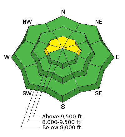
bottom line Once again, the small amount of new snow won't have changed the avalanche danger much and the majority of the terrain has a LOW danger. Because of buried weak snow near the ground and because we keep adding small amounts of new snow on top of it, there is a MODERATE danger that slopes steeper than 35˚ above 9500' that face west, north and east could be triggered by a person and avalanche. I continue to avoid many large avalanche paths because I don't trust the weak snow near the ground.
|
 |
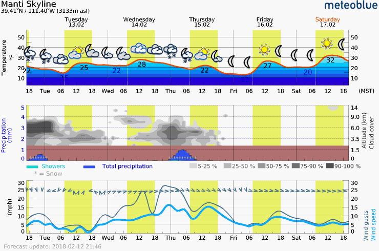
current conditions The Skyline received about 3" of new snow on Monday morning. It originally looked like we might get a few more overnight but that did not materialize. The wind is very light with many stations reading and east direction. Mountain temperatures are around 20˚F. |
 |
weather
|
| general announcements Support the Utah Avalanche Center through your everyday shopping. DETAILS HERE We will publish full detailed advisories Saturday and Sunday mornings by 7am. We will also be publishing basic avalanche danger ratings & info during the week. If you are getting out into the mountains, we love to hear from you! You can SUBMIT OBSERVATIONS ONLINE or EMAIL US If you would like to have avalanche advisories emailed to you, SIGN UP HERE We can provide basic avalanche awareness presentations for your school, group or club. To enquire, CLICK HERE |