25th Annual Black Diamond Fall Fundraising Party
Thursday, September 13; 6:00-10:00 PM; Black Diamond Parking Lot
25th Annual Black Diamond Fall Fundraising Party
Thursday, September 13; 6:00-10:00 PM; Black Diamond Parking Lot
| Advisory: Skyline Area Mountains | Issued by Brett Kobernik for Sunday - January 14, 2018 - 6:49am |
|---|

|
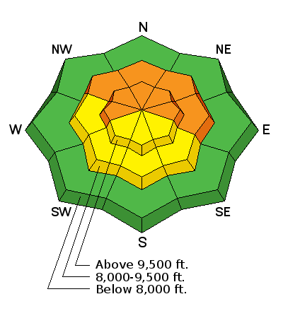
bottom line The avalanche danger remains CONSIDERABLE on the steep west, north and east facing slopes above around 9000' or so. Human triggered avalanches are likely today. This year's very unstable snowpack is the complete opposite of last year's stable snowpack. We need to adjust our riding and dial everything back until we see stability improve.
|
 |
special announcement Be sure to join us at Big Pine Sports on Thursday, January 25th for a free avalanche presentation. DETAILS HERE We are offering a Motorized Backcountry 101 avalanche class on February 10th. DETAILS HERE |
 |
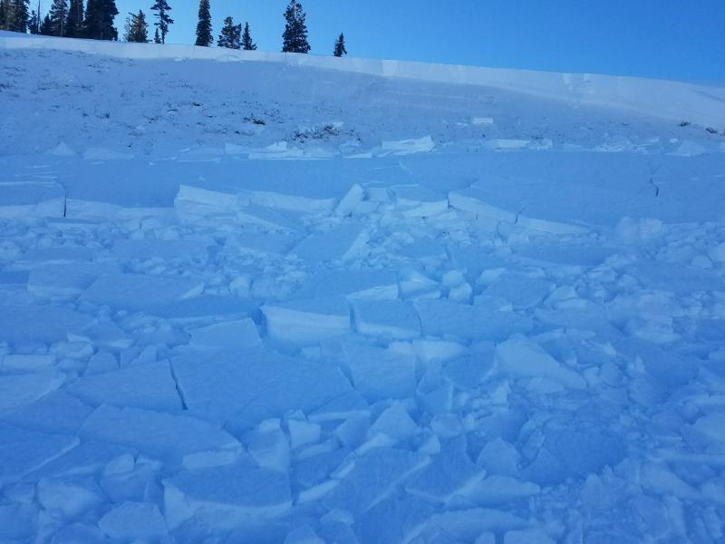
current conditions Saturday was a pleasant day in the hills with mostly sunny skies and mild temperatures. Sunny facing slopes became damp and then crusted as they refroze. Nice cold powder was found by many on the shady aspects. Collapsing continued to be the rule and not the exception. My partner and I traveled on skis and continually experienced startling large collapses that made us stop. We felt the snow drop on a number of these. Another party of 4 had hit a meadow on Snowmobiles pretty hard, carving and playing on small hills. They regrouped in the center of the meadow to take a break. After a minute or two, the entire meadow collapsed underneath them. |
 |
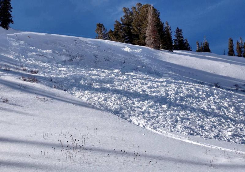
recent activity On Saturday, a snowmobiler in Ephraim Canyon triggered an avalanche while approaching a slope from the bottom. The slope was just east of the popular snowmobile hill "The Monster". The rider was not caught or injured. DETAILS Photo: Pickle
Another avalanche was reported which appears to have released naturally at the tail end of the Wednesday's storm. This was also in Ephraim Canyon on the second bench of Philadelphia Flats. DETAILS Photo: Mike Stevens
|
| type | aspect/elevation | characteristics |
|---|

|
|
LIKELIHOOD
 LIKELY
UNLIKELY
SIZE
 LARGE
SMALL
TREND
 INCREASING DANGER
SAME
DECREASING DANGER
|
|
description
Human triggered avalanches, LARGE thundering collapses and cracking. At this point, things are very obvious. The old weak snow can't support the new snow that we're adding on top. This situation most likely will get worse before it gets better. Today, human triggered avalanches are again likely. Things will most likely get even more dangerous if the anticipated storms this coming week produce any snow. |
 |
weather High pressure continues today with mostly sunny skies, mild temperatures and light northwest wind. Monday looks fairly similar. This is accident weather. Nice weather on a busy holiday weekend for people who have been powder starved coupled with unstable snow conditions spells an accident waiting to happen. Please be careful. |
| general announcements Support the Utah Avalanche Center through your everyday shopping. DETAILS HERE We will publish full detailed advisories Saturday and Sunday mornings by 7am. We will also be publishing basic avalanche danger ratings & info during the week. If you are getting out into the mountains, we love to hear from you! You can SUBMIT OBSERVATIONS ONLINE or EMAIL US If you would like to have avalanche advisories emailed to you, SIGN UP HERE We can provide basic avalanche awareness presentations for your school, group or club. To enquire, CLICK HERE |