25th Annual Black Diamond Fall Fundraising Party
Thursday, September 13; 6:00-10:00 PM; Black Diamond Parking Lot
25th Annual Black Diamond Fall Fundraising Party
Thursday, September 13; 6:00-10:00 PM; Black Diamond Parking Lot
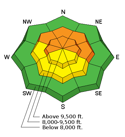
| Advisory: Skyline Area Mountains | Issued by Brett Kobernik for Saturday - January 13, 2018 - 3:58am |
|---|

|
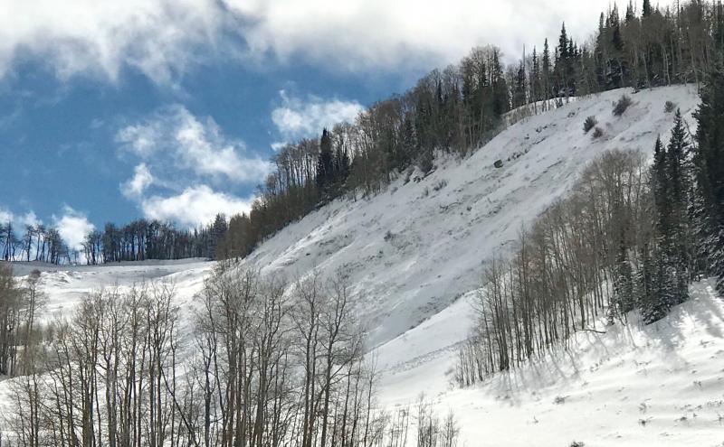
bottom line The avalanche danger remains CONSIDERABLE on the steep west, north and east facing slopes above around 9000' or so. Continued collapsing of the snowpack on Friday demonstrates how unstable the snow is. Human triggered avalanches are likely today especially on the more northerly facing slopes.
|
 |
special announcement Be sure to join us at Big Pine Sports on Thursday, January 25th for a free avalanche presentation. DETAILS HERE We are offering a Motorized Backcountry 101 avalanche class on February 10th. DETAILS HERE |
 |
current conditions A storm that moved through Tuesday and Wednesday added about 6 inches of snow in the higher terrain along the Skyline. This has capped off all of the weak snow from October, November and December. It wasn't enough to produce a widespread natural avalanche cycle. However, since the storm, anyone who has been traveling in the backcountry has noted collapsing and cracking of the snowpack through yesterday. These are two major signs of avalanche danger. When the snowpack collapses (loud WHOOMPING underneath you) but doesn't avalanche, the only reason it didn't avalanche was the slope wasn't steep enough. Below is a backcountry observation from the top of Fairview Canyon that describes much of what we're seeing across the entire Skyline. 01/12/2018 Observation: GE Hill/Skyline Summit Skyline region Darce Trotter / Steve Cote |
 |
recent activity I was down in the Gooseberry zone in the Fish Lake region on Friday and we found a number of natural avalanches that occurred during the Tues-Weds storm. The Fish Lake mountains picked up about a foot of snow which is more than the Skyline received. In general, the Fish Lake region has a similar snowpack set up as the Skyline, weak snow from October, November and December capped off by the last two storms. AVALANCHE REPORT FROM W OF LOST CREEK RES.
|
| type | aspect/elevation | characteristics |
|---|

|
|
LIKELIHOOD
 LIKELY
UNLIKELY
SIZE
 LARGE
SMALL
TREND
 INCREASING DANGER
SAME
DECREASING DANGER
|
|
description
There is no mystery to what is going on. The snowpack is unstable due to old weak snow now getting overloaded with new snow. Collapsing and cracking are the two major red flags that continue to tell us that the snowpack is unstable. The last two storms are only giving us a hint of the avalanche activity that is possible with this set up. This old weak snow will continue to be our main avalanche concern for some time to come. Do not forget about it once there is enough snow to really start traveling around! |
 |
weather A ridge of high pressure is moving in for the weekend. We'll see mostly sunny skies today with ridge top high temperatures in the low 30s and fairly light wind from the northwest. Sunday and Monday look similar with slightly warmer temperatures. It looks like we'll see a small storm move through about mid week and another storm shaping up for next weekend. |
| general announcements Support the Utah Avalanche Center through your everyday shopping. DETAILS HERE We will publish full detailed advisories Saturday and Sunday mornings by 7am. We will also be publishing basic avalanche danger ratings & info during the week. If you are getting out into the mountains, we love to hear from you! You can SUBMIT OBSERVATIONS ONLINE or EMAIL US If you would like to have avalanche advisories emailed to you, SIGN UP HERE We can provide basic avalanche awareness presentations for your school, group or club. To enquire, CLICK HERE |