25th Annual Black Diamond Fall Fundraising Party
Thursday, September 13; 6:00-10:00 PM; Black Diamond Parking Lot
25th Annual Black Diamond Fall Fundraising Party
Thursday, September 13; 6:00-10:00 PM; Black Diamond Parking Lot
| Advisory: Skyline Area Mountains | Issued by Brett Kobernik for Friday - December 22, 2017 - 7:27pm |
|---|

|
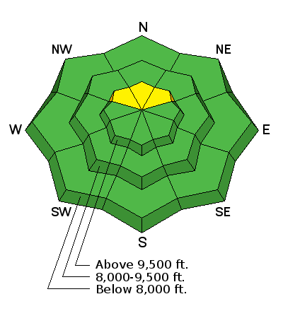
bottom line Overall the avalanche danger is generally LOW. There is a "pockety" MODERATE danger where a fresh wind drift may have formed on top of weak pre-existing snow on the more northerly facing slopes above about 9500'. Avoid these slopes if you are not able to determine whether there is a "slab" present on top of the weak snow.
|
 |
current conditions Friday was a very nice day up in the hills with lots of sun and fresh snow. West wind was a little blustery along the ridgetops. Daytime highs were in the low to mid 20s. Overnight, the wind picked up a bit more and temperatures stayed in the low to mid 20s. A few flakes of snow are currently falling. |
| type | aspect/elevation | characteristics |
|---|

|

|
LIKELIHOOD
 LIKELY
UNLIKELY
SIZE
 LARGE
SMALL
TREND
 INCREASING DANGER
SAME
DECREASING DANGER
|
|
description
Weak snow from October and November has formed on the north facing slopes above about 9500'. The recent storm didn't overload this weak snow. The recent west wind might have transported enough of the new low density powder creating some pockets that might release if provoked. These avalanches won't be all that big but could ruin your day nonetheless. It's a "Catch 22" because these upper elevation north facing slopes are exactly where we want to go since they are holding the most snow right now. Approach these slopes with caution. It's a much different winter compared to last winter so far. |
 |
weather We're going to see the chance for snow today with a few inches possible in the high terrain. Up on the ridges, high temperatures will be in the low to mid 20s and west northwest wind will blow in the moderate to strong range. Sunday will be partly cloudy with slightly warmer temperatures and slower west wind. Another little disturbance will move through Christmas Eve and Christmas Day which might bring a few more inches of snow. After that, I'm not seeing any significant storms through next week. |
| general announcements We will publish full detailed advisories Saturday and Sunday mornings by 7am. We will also be publishing basic avalanche danger ratings & info during the week. If you are getting out into the mountains, we love to hear from you! You can SUBMIT OBSERVATIONS ONLINE or EMAIL US If you would like to have avalanche advisories emailed to you, SIGN UP HERE We can provide basic avalanche awareness presentations for your school, group or club. To enquire, CLICK HERE |


