25th Annual Black Diamond Fall Fundraising Party
Thursday, September 13; 6:00-10:00 PM; Black Diamond Parking Lot
25th Annual Black Diamond Fall Fundraising Party
Thursday, September 13; 6:00-10:00 PM; Black Diamond Parking Lot
| Advisory: Skyline Area Mountains | Issued by Brett Kobernik for Saturday - February 25, 2017 - 6:41am |
|---|

|
bottom line Most of the terrain has a LOW avalanche danger. A "pockety" MODERATE avalanche danger exists along the higher and more exposed easterly facing steep terrain where a person might trigger a recently formed wind slab. Don't let your guard down. Continue to put one person on steep slopes at a time and clear the avalanche run-out zone at the bottom.
|
 |
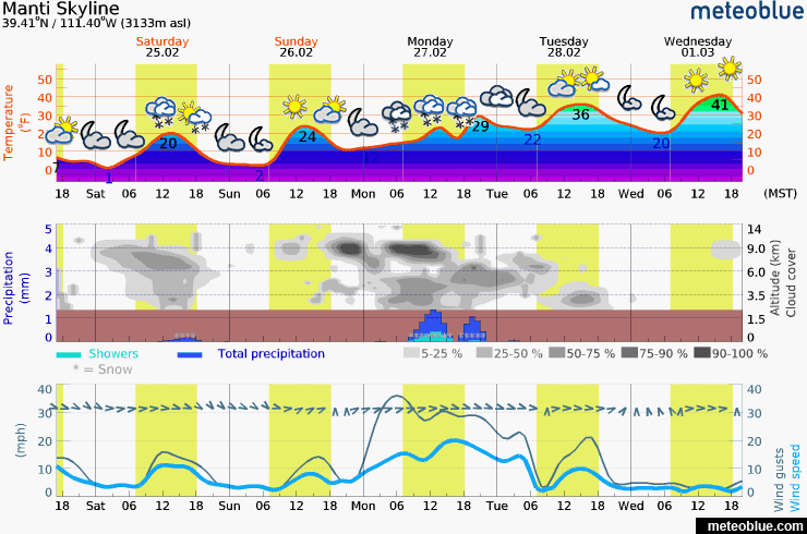
current conditions Instability showers lingered through Friday but didn't add a whole lot of new snow. Totals for the entire storm since Weds are 10 to 13 inches. The new snow was very low density powder on Friday and should be fairly similar today. Overnight temperatures were quite cold with lows below zero at many mountain stations. West wind continues to slow and is generally light. Without any significant weak layers in the snowpack and since the new snow bonded well, the overall avalanche danger is quite manageable. Darce Trotter and Steve Cote were out on Friday skiing and looking at the snow. Here's a quick video clip of what they were seeing: Check out their full observations HERE. |
| type | aspect/elevation | characteristics |
|---|

|
|
LIKELIHOOD
 LIKELY
UNLIKELY
SIZE
 LARGE
SMALL
TREND
 INCREASING DANGER
SAME
DECREASING DANGER
|
|
description
The wind did blow the new snow around a bit forming some drifts and slabs along the higher terrain. The few I poked at on Friday were not reactive. They will continue to get more stubborn as time goes on. However, I would still give them respect especially if you're getting into more exposed and radical terrain. Wind effected terrain will be the only place that you'll find trouble today. |
 |
weather We'll see increasing clouds today and the chance for snow as the day goes on. A minor system will move through this afternoon and evening bringing a few inches of snow. Mountain daytime high temperatures should get into the upper teens. West wind should be light to moderate in speed. Sunday looks mostly clear then another storm is shaping up for early in the week.
|
| general announcements We will publish full detailed advisories Saturday and Sunday mornings by 7am. We will also be publishing basic avalanche danger ratings & info during the week. If you are getting out into the mountains, we love to hear from you! You can SUBMIT OBSERVATIONS ONLINE or EMAIL US If you would like to have avalanche advisories emailed to you, SIGN UP HERE We can provide basic avalanche awareness presentations for your school, group or club. To enquire, CLICK HERE |