25th Annual Black Diamond Fall Fundraising Party
Thursday, September 13; 6:00-10:00 PM; Black Diamond Parking Lot
25th Annual Black Diamond Fall Fundraising Party
Thursday, September 13; 6:00-10:00 PM; Black Diamond Parking Lot
| Advisory: Skyline Area Mountains | Issued by Brett Kobernik for Wednesday - February 22, 2017 - 7:00am |
|---|

|
bottom line In most terrain, the avalanche danger is generally LOW. There is a MODERATE danger in the wind effected areas along the higher terrain where small human triggered avalanches are possible. Anticipate the danger to increase a bit on Thursday.
|
 |
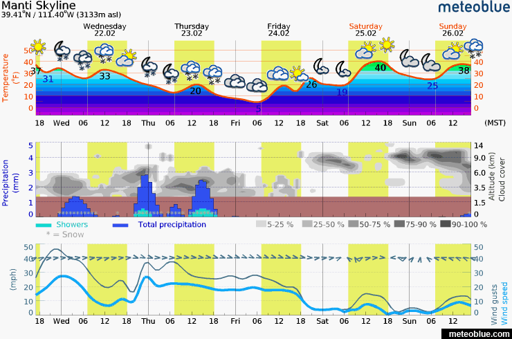
current conditions Strong southwest wind has been blowing overnight with gusts to 60 on the highest peaks. Temperatures dipped into the mid 20s overnight. There was a trace of new snow accumulation. |
 |
weather A storm system will continue to move through today and tonight bringing 4 to 8 inches of snow to the Manti Skyline. We won't see significant accumulation until later today and tonight. Temperatures remain mild today and drop into the teens tonight. Southwest wind will slow some and shift northwest. We'll still see moderate speed wind through the storm.
|
| general announcements We will publish full detailed advisories Saturday and Sunday mornings by 7am. We will also be publishing basic avalanche danger ratings & info during the week. If you are getting out into the mountains, we love to hear from you! You can SUBMIT OBSERVATIONS ONLINE or EMAIL US If you would like to have avalanche advisories emailed to you, SIGN UP HERE We can provide basic avalanche awareness presentations for your school, group or club. To enquire, CLICK HERE |