25th Annual Black Diamond Fall Fundraising Party
Thursday, September 13; 6:00-10:00 PM; Black Diamond Parking Lot
25th Annual Black Diamond Fall Fundraising Party
Thursday, September 13; 6:00-10:00 PM; Black Diamond Parking Lot
| Advisory: Skyline Area Mountains | Issued by Brett Kobernik for Friday - February 17, 2017 - 6:58am |
|---|


|
bottom line The avalanche danger is generally LOW.
|
 |
current conditions The mountains received a trace of snow overnight. Riding conditions remain good on the northerly facing slopes. The snow surface on the more northerly slopes became somewhat weak over the last 5 days of clear weather and fairly cold nights. The current loose snow on the surface could act as a weak layer once it's buried with this weekend's storm. However, I don't think the current snow surface became weak enough to be much of a concern. Stay tuned, I'll be watching this layer as snow piles up on top of it. |
 |
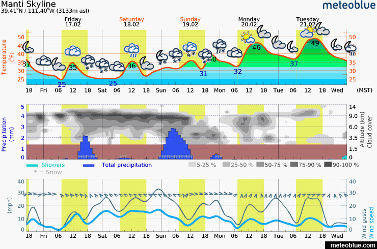
weather We have another warm storm anticipated for this weekend that could bring 10 to 18 inches of snow to the high country. We'll see periods of snow from later today through Sunday. Rain/snow levels will start out around 7000 feet. The most intense periods of snow look like late today and then again Sunday with a cold front moving through. Wind does not look real strong with this storm. It will be from the southeast later today and through Saturday. This flow may favor areas on the east side of the Manti Skyline. The flow turns more west on Sunday.
|
| general announcements We will publish full detailed advisories Saturday and Sunday mornings by 7am. We will also be publishing basic avalanche danger ratings & info during the week. If you are getting out into the mountains, we love to hear from you! You can SUBMIT OBSERVATIONS ONLINE or EMAIL US If you would like to have avalanche advisories emailed to you, SIGN UP HERE We can provide basic avalanche awareness presentations for your school, group or club. To enquire, CLICK HERE |