25th Annual Black Diamond Fall Fundraising Party
Thursday, September 13; 6:00-10:00 PM; Black Diamond Parking Lot
25th Annual Black Diamond Fall Fundraising Party
Thursday, September 13; 6:00-10:00 PM; Black Diamond Parking Lot
| Advisory: Skyline Area Mountains | Issued by Brett Kobernik for Wednesday - February 8, 2017 - 6:42am |
|---|

|
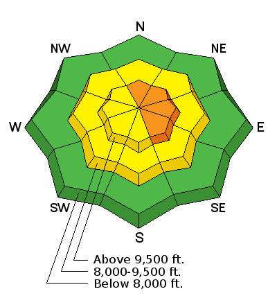
bottom line The overall avalanche danger is MODERATE. There is a CONSIDERABLE avalanche danger along the upper elevation ridgelines where the wind has been drifting snow. These fresh slabs of snow will most likely be sensitive to a person. Avoid cornices as they will most likely be sensitive also.
|
 |
special announcement I NEED SOME HELP!!! I'm wondering if I am providing you with enough information to understand daily avalanche conditions. KEEP IN MIND that we only have the resources to produce full detailed advisories on the weekends. Please click "Yes" or "No, add comments if you wish, and click submit to help me continue to provide you with what you need. |
 |
current conditions The storm is going to end up producing less snow than anticipated. The majority of the precipitation stayed to our north. The Fairview Canyon/Electric Lake area picked up about 6 inches of dense snow. Farther south on the Skyline you'll only find about two inches of new dense snow. The wind has been strong from the west southwest. Mountain temperatures are mild with most stations reading around freezing. |
 |
weather The current storm is winding down and not much, if any, snow accumulation is anticipated today. Our focus now shifts to the next storm scheduled for Friday into Saturday. We should see some snow however, it looks as if the majority of the energy is going to dive south of us.
|
| general announcements We will publish full detailed advisories Saturday and Sunday mornings by 7am. We will also be publishing basic avalanche danger ratings & info during the week. If you are getting out into the mountains, we love to hear from you! You can SUBMIT OBSERVATIONS ONLINE or EMAIL US If you would like to have avalanche advisories emailed to you, SIGN UP HERE We can provide basic avalanche awareness presentations for your school, group or club. To enquire, CLICK HERE |


