25th Annual Black Diamond Fall Fundraising Party
Thursday, September 13; 6:00-10:00 PM; Black Diamond Parking Lot
25th Annual Black Diamond Fall Fundraising Party
Thursday, September 13; 6:00-10:00 PM; Black Diamond Parking Lot
| Advisory: Skyline Area Mountains | Issued by Brett Kobernik for Sunday - January 8, 2017 - 6:46am |
|---|


|
bottom line The avalanche danger will increase today and over the next few days. The avalanche danger is CONSIDERABLE today and may reach HIGH danger on Monday if the storm actually produces. With a known buried weak layer of snow and more snow and wind expected, it's a time to use a lot of caution out in the mountains.
|
 |
special announcement
I'll be doing an avalanche presentation at Big Pine Sports Thursday, January 12th at 6:30pm. I'll be covering a bunch of topics including "Persistent Weak Layer Formation" which is about how these weak layers form and how to manage them once they're buried. There will be food and drinks and some discounts on gear. Come join us and get a little more avalanche education! DETAILS
Big thanks to SnowBigDeal and Klim for your continued support of the avalanche center. I cannot stress how important good gear is out in the backcountry. You guys have come through! |
 |
current conditions We've received about 3 inches of new snow since Saturday afternoon. Temperatures have warmed and most stations are right around 30 degrees. Southwest ridgetop wind is not too strong right now with light to moderate speeds. Riding conditions were excellent on Saturday. The snow will probably have a different feel today as we are adding a higher density new snow on top of the lighter powder from the last storm. |
| type | aspect/elevation | characteristics |
|---|

|
|
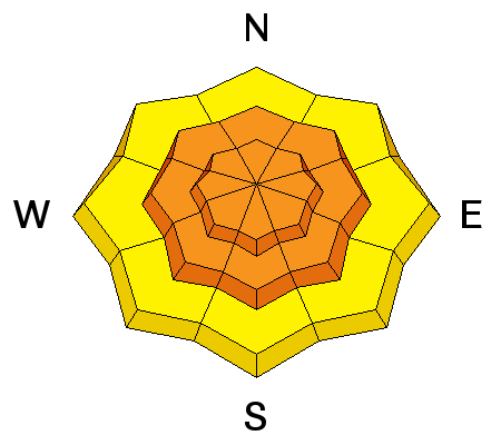
LIKELIHOOD
 LIKELY
UNLIKELY
SIZE
 LARGE
SMALL
TREND
 INCREASING DANGER
SAME
DECREASING DANGER
|
|
description
The most dangerous issue today is if you trigger an avalanche that breaks down to the Christmas weak layer. During fieldwork on Saturday, our test results on this layer were still producing very clean shears. However, they were stubborn to pop out. I am still hopeful that this weak layer will stabilize and not haunt us for weeks to come. If weather forecasts verify, we should be adding quite a bit of water weight on top of it over the next week. If we don't see avalanches breaking down to this layer, I'll start to feel a bit better. |
| type | aspect/elevation | characteristics |
|---|

|
|
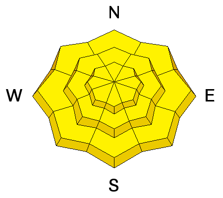
LIKELIHOOD
 LIKELY
UNLIKELY
SIZE
LARGE
SMALL
TREND
 INCREASING DANGER
SAME
DECREASING DANGER
|
|
description
The new snow that is expected to fall today may be unstable it's self. Last week's cold low density snow may act as a weak layer. I'm not sure we'll see enough new snow during the day for this to be a serious issue but you should be aware that the new snow may be sensitive. |
 |
weather The first of a series of storm waves is putting down snow in the mountains now. We should see 3 to 7 inches of snow accumulations today. The snow is going to be dense and we'll see the rain-snow line rise to around 8500' or perhaps a bit higher. Temperatures will be quite warm with ridgetop readings around freezing. Southwest wind speeds will increase with stronger gusts and stay that way into Tuesday. Another impulse is going to give us more snow on Monday with the rain-snow line lowering again. Yet more snow is anticipated through Friday. We could see up to 3 inches of water by the end of the week which translates into 2 to 3 feet of snow. |
| general announcements We will publish full detailed advisories Saturday and Sunday mornings by 7am. We will also be publishing basic avalanche danger ratings & info during the week. If you are getting out into the mountains, we love to hear from you! You can SUBMIT OBSERVATIONS ONLINE or EMAIL US If you would like to have avalanche advisories emailed to you, SIGN UP HERE We can provide basic avalanche awareness presentations for your school, group or club. To enquire, CLICK HERE |


