25th Annual Black Diamond Fall Fundraising Party
Thursday, September 13; 6:00-10:00 PM; Black Diamond Parking Lot
25th Annual Black Diamond Fall Fundraising Party
Thursday, September 13; 6:00-10:00 PM; Black Diamond Parking Lot
| Advisory: Skyline Area Mountains | Issued by Brett Kobernik for Saturday - January 7, 2017 - 6:52am |
|---|

|
bottom line The avalanche danger is CONSIDERABLE today. Human triggered avalanches are likely on random slopes. Wind sheltered slopes are just as suspect as wind loaded slopes. Stay on slopes less than 30 degrees in steepness to not get caught in an avalanche.
|
 |
special announcement
I'll be doing an avalanche presentation at Big Pine Sports Thursday, January 12th at 6:30pm. I'll be covering a bunch of topics including "Persistent Weak Layer Formation" which is about how these weak layers form and how to manage them once they're buried. There will be food and drinks and some discounts on gear. Come join us and get a little more avalanche education! DETAILS
Big thanks to SnowBigDeal and Klim for your continued support of the avalanche center. I cannot stress how important good gear is out in the backcountry. You guys have come through! |
 |
current conditions It was a gorgeous day on Friday although a bit chilly! Fresh powder, light winds and mostly clear skies. We learned a bit more about the buried weak layer of snow that I have been a little concerned about. But first, check out this video (if you haven't already) of some fieldwork from Thursday: LINK TO VIDEO TALKING ABOUT CONCERNS FOR FRIDAY AND SATURDAY |
 |
recent activity There was a large skier triggered avalanche on Friday. Actually, they triggered it from a distance from chunks of snow rolling downhill from a snowpit they were digging. They were in a safe location and were not caught. It was about 2 feet deep, 250 feet wide and ran 600 feet vertical. Fracture lines were also visible from natural avalanches that released during the storm near the Huntington Reservoir area.
LINK TO VIDEO OF DARCE TROTTER CHECKING OUT THE FRACTURE LINE OF THE AVALANCHE THEY TRIGGERED |
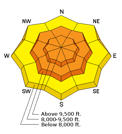
| type | aspect/elevation | characteristics |
|---|

|
|
LIKELIHOOD
 LIKELY
UNLIKELY
SIZE
 LARGE
SMALL
TREND
 INCREASING DANGER
SAME
DECREASING DANGER
|
|
description
The recent avalanche activity confirms that we have something to be concerned about out there right now. There are surely more slopes hanging around waiting for one of us to tickle them. The tricky thing is that not every slope is going to avalanche. Many are going to allow riders to climb them without incident. This can lend to a false sense of security. Some slopes are "booby trapped" and it's very difficult to know which slopes will or will not avalanche. The only way to stay 100% safe is to stay on slopes less than 30 degrees until things stabilize again, |
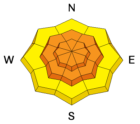
| type | aspect/elevation | characteristics |
|---|

|

|
LIKELIHOOD
 LIKELY
UNLIKELY
SIZE
LARGE
SMALL
TREND
 INCREASING DANGER
SAME
DECREASING DANGER
|
|
description
A secondary concern is wind drifting snow today. Southwest wind will increase a bit today. There is a lot of low density snow available for transport. Even moderate speed wind should have no problem forming fresh drifts. This could overload some slopes and cause them to avalanche. |
 |
weather We're going to see high clouds moving in then the chance for snow flurries this afternoon. Temperatures will be much warmer than Friday with a ridgetop high in the low to mid 20s. Southwest winds will increase into at least the moderate speed category along the ridges. We'll see a wet and unsettled period of weather for the next week. Numerous impulses will move through with the timing and snow amounts somewhat uncertain. We should see some snow on Sunday, perhaps a few inches accumulation. Monday looks like a little more active for our area. All told, if weather models are accurate with water amounts, we could see a couple more feet of snow by the end of the week. |
| general announcements We will publish full detailed advisories Saturday and Sunday mornings by 7am. We will also be publishing basic avalanche danger ratings & info during the week. If you are getting out into the mountains, we love to hear from you! You can SUBMIT OBSERVATIONS ONLINE or EMAIL US If you would like to have avalanche advisories emailed to you, SIGN UP HERE We can provide basic avalanche awareness presentations for your school, group or club. To enquire, CLICK HERE |


