25th Annual Black Diamond Fall Fundraising Party
Thursday, September 13; 6:00-10:00 PM; Black Diamond Parking Lot
25th Annual Black Diamond Fall Fundraising Party
Thursday, September 13; 6:00-10:00 PM; Black Diamond Parking Lot
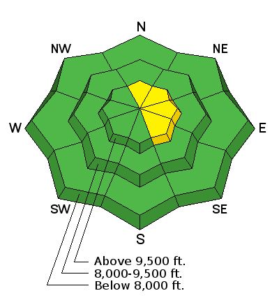
| Advisory: Skyline Area Mountains | Issued by Brett Kobernik for Saturday - December 31, 2016 - 7:02am |
|---|

|
bottom line The avalanche danger is generally LOW in the majority of the terrain. There is a "pockety" MODERATE avalanche danger along the higher more east facing steep terrain where isolated wind drifts could be triggered by a person.
|
 |
current conditions It was a windy day on Friday in the higher terrain. The wind was fairly well behaved once you dropped off the exposed ridgelines. The wind has slowed a bit overnight. Ridgetop temperatures are around 20 degrees. Riding conditions are generally pretty good in a lot of places that have not seen wind damage from this past week. Overall the snowpack is fairly stable right now. I am slightly concerned that the snow surface is turning into a weak layer which may produce avalanches once it is buried by future snow storms. I'm not saying it's "doomsday" at this point. I will be paying close attention to the condition of the snow surface prior to the next snow storms. I'll give some more details on this in tomorrow's forecast. Below is a link to what Darce and Steve were finding in the Big Meadow near Miller Flat trailhead.
|
| type | aspect/elevation | characteristics |
|---|

|
|
LIKELIHOOD
 LIKELY
UNLIKELY
SIZE
 LARGE
SMALL
TREND
 INCREASING DANGER
SAME
DECREASING DANGER
|
|
description
For today the only thing you really need to watch for is the drifts along the higher more exposed terrain. The wind formed these over the past week. At this point they are quite stubborn. My partner and I traveled extensively on Friday and poked at countless drifts. We could not get any of them to crack. However, I suspect that on VERY steep slopes, it's possible that a person could get one to release. |
 |
weather It looks like another fairly nice day today. Wind speeds along the upper ridges should be a little slower than on Friday. High temperatures in the upper elevations will get into the upper 20s. We'll see a few more clouds on Sunday with a slight chance of snow flurries. A more significant storm moves in for the early part of the week which should bring us a decent shot of new snow. |
| general announcements We will publish full detailed advisories Saturday and Sunday mornings by 7am. We will also be publishing basic avalanche danger ratings & info during the week. If you are getting out into the mountains, we love to hear from you! You can SUBMIT OBSERVATIONS ONLINE or EMAIL US If you would like to have avalanche advisories emailed to you, SIGN UP HERE We can provide basic avalanche awareness presentations for your school, group or club. To enquire, CLICK HERE |


