25th Annual Black Diamond Fall Fundraising Party
Thursday, September 13; 6:00-10:00 PM; Black Diamond Parking Lot
25th Annual Black Diamond Fall Fundraising Party
Thursday, September 13; 6:00-10:00 PM; Black Diamond Parking Lot
| Advisory: Skyline Area Mountains | Issued by Brett Kobernik for Friday - December 30, 2016 - 6:57am |
|---|


|
bottom line There is a LOW avalanche danger in most of the terrain. An isolated MODERATE avalanche danger exists on the steepest more east facing high elevation terrain. It is possible that a recently formed drift could still be triggered. It looks like the wind will increase from the west southwest later today. You may see some new drifts forming which you will want to avoid if they are on very steep slopes.
|
 |
current conditions The wind was almost nonexistent on Thursday with clear skies and mild temperatures. Plenty of good snow remains out of the most exposed higher terrain. Southerly slopes heated up and you'll find a crust on them this morning before they soften later in the day. |
 |
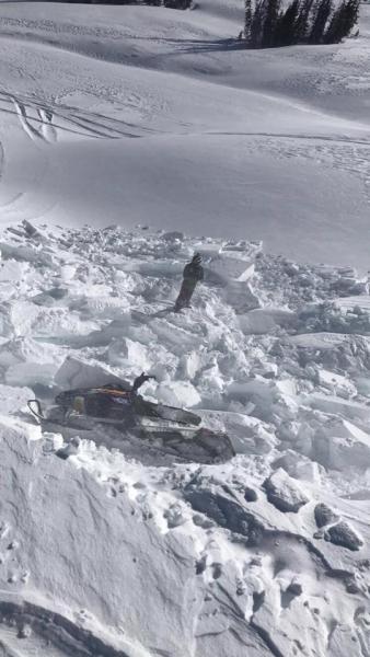
recent activity No avalanches were reported from Thursday. A snowmobiler triggered a small wind drift in upper Ephraim Canyon and was caught and carried a short distance in it on Wednesday. DETAILS HERE This is the typical type of activity to anticipate along the higher ridges. Since the wind stopped and more time goes by, these drifts will become more stubborn and not so likely to release on a person. I tested numerous drifts on steep slopes on Thursday and I was not able to get any of them to crack out. Photo below: Snowmobile triggered wind drift in Ephraim Canyon, courtesy of Cade Beck.
|
 |
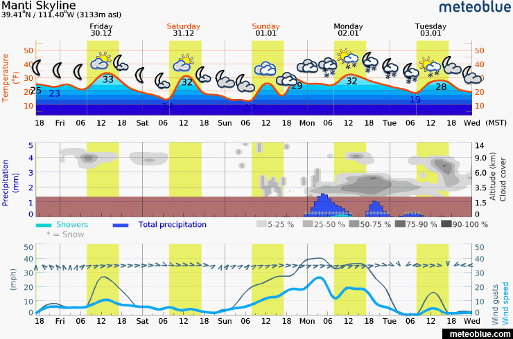
weather
|
| general announcements We will publish full detailed advisories Saturday and Sunday mornings by 7am. We will also be publishing basic avalanche danger ratings & info during the week. If you are getting out into the mountains, we love to hear from you! You can SUBMIT OBSERVATIONS ONLINE or EMAIL US If you would like to have avalanche advisories emailed to you, SIGN UP HERE We can provide basic avalanche awareness presentations for your school, group or club. To enquire, CLICK HERE |