25th Annual Black Diamond Fall Fundraising Party
Thursday, September 13; 6:00-10:00 PM; Black Diamond Parking Lot
25th Annual Black Diamond Fall Fundraising Party
Thursday, September 13; 6:00-10:00 PM; Black Diamond Parking Lot
| Advisory: Skyline Area Mountains | Issued by Brett Kobernik for Tuesday - December 13, 2016 - 6:53am |
|---|

|
bottom line There remains a MODERATE avalanche danger along the highest ridges and peaks where a snow drift formed by the recent winds may still release with the weight of a person. Avoid steep slopes in the high terrain facing north through southeast that have a rippled, "pillowy", or textured look to them. Out of the wind affected snow, the danger is generally LOW.
|
 |
special announcement Please join us at Big Pine Sports for an avalanche presentation on Thursday, Dec 15th at 6:30pm. I will be talking about the current conditions and sharing tips on how to stay out of avalanches. I'll cover anything else avalanche related the audience is interested in.
|
 |
current conditions Steve Cote sent in a backcountry observation from Monday. Check it out HERE |
 |
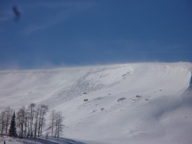
recent activity There was at least one natural avalanche that released during the day on Monday during the strong westerly wind. This is pretty typical of what to anticipate out there right now.
|
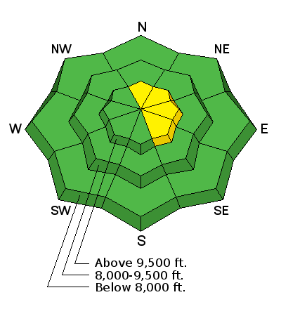
| type | aspect/elevation | characteristics |
|---|

|
|
LIKELIHOOD
 LIKELY
UNLIKELY
SIZE
 LARGE
SMALL
TREND
 INCREASING DANGER
SAME
DECREASING DANGER
|
|
description
Triggering a fresh wind slab on the more east facing steep terrain is the biggest avalanche concern out there right now. These will be a bit more stubborn today than yesterday. |
 |
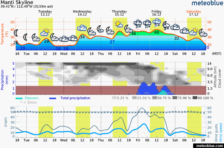
weather
|
| general announcements We will publish full detailed advisories Saturday and Sunday mornings by 7am. We will also be publishing basic avalanche danger ratings & info during the week. If you are getting out into the mountains, we love to hear from you! You can SUBMIT OBSERVATIONS ONLINE or EMAIL US If you would like to have avalanche advisories emailed to you, SIGN UP HERE We can provide basic avalanche awareness presentations for your school, group or club. To enquire, CLICK HERE |