25th Annual Black Diamond Fall Fundraising Party
Thursday, September 13; 6:00-10:00 PM; Black Diamond Parking Lot
25th Annual Black Diamond Fall Fundraising Party
Thursday, September 13; 6:00-10:00 PM; Black Diamond Parking Lot
| Advisory: Skyline Area Mountains | Issued by Brett Kobernik for Sunday - December 11, 2016 - 6:59am |
|---|

|
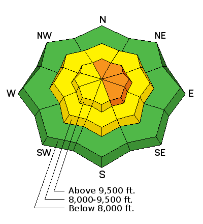
bottom line The avalanche danger is CONSIDERABLE on slopes steeper than 35 degrees that face north through southeast along the higher ridges and peaks. A person is likely to trigger a fresh wind drift in this terrain. If you avoid areas where the wind has been drifting snow, the avalanche danger is LOW to MODERATE.
|
 |
special announcement Please join us at Big Pine Sports for an avalanche presentation on Thursday, Dec 15th at 6:30pm. I will be talking about the current conditions and sharing tips on how to stay out of avalanches. I'll cover anything else avalanche related the audience is interested in.
|
 |
current conditions The storm ended up not being a total bust. We wound up with about 6 inches of snow in the last 24 hours. The wind has continued to be strong along the higher terrain generally from the west. It does look like it has slowed slightly over the last couple of hours. Temperatures in the high country have cooled down into the mid to lower 20s. |
| type | aspect/elevation | characteristics |
|---|

|
|
LIKELIHOOD
 LIKELY
UNLIKELY
SIZE
 LARGE
SMALL
TREND
 INCREASING DANGER
SAME
DECREASING DANGER
|
|
description
I don't really know just how sensitive the fresh wind drifts are. Here's what I do know. The wind has been strong from the west for a number of days. Wind can transport and deposit snow 10 times faster than it falls out of the sky rapidly forming drifts. These drifts are always the most sensitive during the time that they are forming and directly after. Knowing we have new snow available for transport and that the wind has been blowing, I'm assuming the east facing slopes have been wind loaded. There is no way I would venture onto a steep lee (easterly facing) slope today. |
 |
weather The storm is moving to our east and snowfall is tapering off. We might see a few lingering showers this morning then gradually clearing skies. The west wind is going to continue to be breezy along the higher terrain. We should see ridgetop high temperatures in the mid 20s today. It looks like Monday and Tuesday will be dry then the weather becomes active again with a stormy period starting late Tuesday and a more significant storm moving in on Friday. |
| general announcements We will publish full detailed advisories Saturday and Sunday mornings by 7am. We will also be publishing basic avalanche danger ratings & info during the week. If you are getting out into the mountains, we love to hear from you! You can SUBMIT OBSERVATIONS ONLINE or EMAIL US If you would like to have avalanche advisories emailed to you, SIGN UP HERE We can provide basic avalanche awareness presentations for your school, group or club. To enquire, CLICK HERE |


