25th Annual Black Diamond Fall Fundraising Party
Thursday, September 13; 6:00-10:00 PM; Black Diamond Parking Lot
25th Annual Black Diamond Fall Fundraising Party
Thursday, September 13; 6:00-10:00 PM; Black Diamond Parking Lot
| Advisory: Skyline Area Mountains | Issued by Brett Kobernik for Friday - December 9, 2016 - 6:55am |
|---|

|
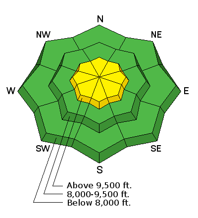
bottom line The avalanche danger is MODERATE along the higher ridgelines where the wind has been drifting snow. Avoid fresh cornices as well as any steep slopes where the wind has been depositing snow recently. Out of the wind effected terrain, the avalanche danger is LOW.
|
 |
special announcement Please join us at Big Pine Sports for an avalanche presentation on Thursday, Dec 15th at 6:30pm. I will be talking about the current conditions and sharing tips on how to stay out of avalanches. I'll cover anything else avalanche related the audience is interested in.
|
 |
current conditions The current storm has been tracking just north of the Skyline. We did pick up a few inches of snow yesterday afternoon and overnight. The wind was strong from the southwest along the higher ridges. Temperatures have been on the rise since Thursday and are in the mid to upper 20s along the higher terrain right now. The snow that is currently on the ground looks pretty good and is stable. The structure of the layers looks good and test results have not shown anything of concern. The avalanche danger will be directly related to what the storm does over the weekend. It looks like our best chance for snow is late Saturday into Sunday with strong wind. |
| type | aspect/elevation | characteristics |
|---|

|
|
LIKELIHOOD
 LIKELY
UNLIKELY
SIZE
 LARGE
SMALL
TREND
 INCREASING DANGER
SAME
DECREASING DANGER
|
|
description
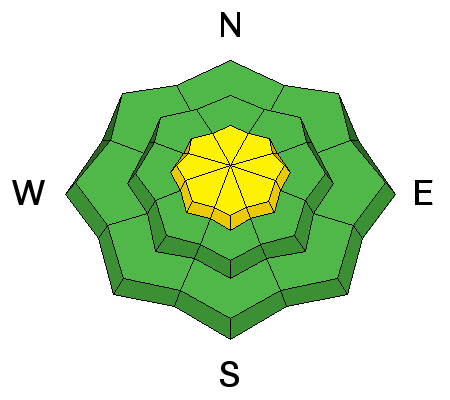
The biggest concern today is a person triggering a fresh wind drift along the higher terrain. The wind was no doubt transporting snow on Thursday. Visibility was poor but my guess is that cornice formation is starting and there are fresh drifts present on the lee sides of the higher ridges. The most likely spots where a person might trigger something today will be on the more east facing terrain. |
 |
weather A small amount of snow may still fall this morning then taper off for the remaining part of the day. Temperatures are going to remain warm with ridgetop highs in the upper 20s. The westerly wind should let up a little bit during the day but will still be blowing along the higher terrain. In general, it's going to be windy through the weekend with the strongest wind Saturday night. Saturday afternoon and evening looks like the most likely chance for picking up some snow. Water amounts might be in the .4 to .8" range giving us 8" of snow or so. |
| general announcements We will publish full detailed advisories Saturday and Sunday mornings by 7am. We will also be publishing basic avalanche danger ratings & info during the week. If you are getting out into the mountains, we love to hear from you! You can SUBMIT OBSERVATIONS ONLINE or EMAIL US If you would like to have avalanche advisories emailed to you, SIGN UP HERE We can provide basic avalanche awareness presentations for your school, group or club. To enquire, CLICK HERE |


