25th Annual Black Diamond Fall Fundraising Party
Thursday, September 13; 6:00-10:00 PM; Black Diamond Parking Lot
25th Annual Black Diamond Fall Fundraising Party
Thursday, September 13; 6:00-10:00 PM; Black Diamond Parking Lot
| Advisory: Skyline Area Mountains | Issued by Brett Kobernik for Friday - November 18, 2016 - 9:30am |
|---|


|
bottom line The avalanche danger is generally LOW. Rocks and stumps under the shallow snow cover presents a much greater hazard than avalanches right now.
|
 |
special announcement Welcome to the 2016-2017 winter season! The staff at the Utah Avalanche Center is busy getting ready for the upcoming season. We are scheduling avalanche classes and talks, testing all of our electronics and weather stations, and starting to publish avalanche advisories. Until there is enough snow on the ground, I will publish avalanche advisories intermittently. I will be publishing avalanche advisories 7 days a week for the Manti-Skyline this winter. I'll put out full advisories on Saturday and Sunday as well as any significant storms that occur mid week. I'll put out abbreviated advisories Monday through Friday with basic danger ratings and reports of any significant avalanche activity. GET THE ADVISORY EMAILED TO YOU subscribe here.
|
 |
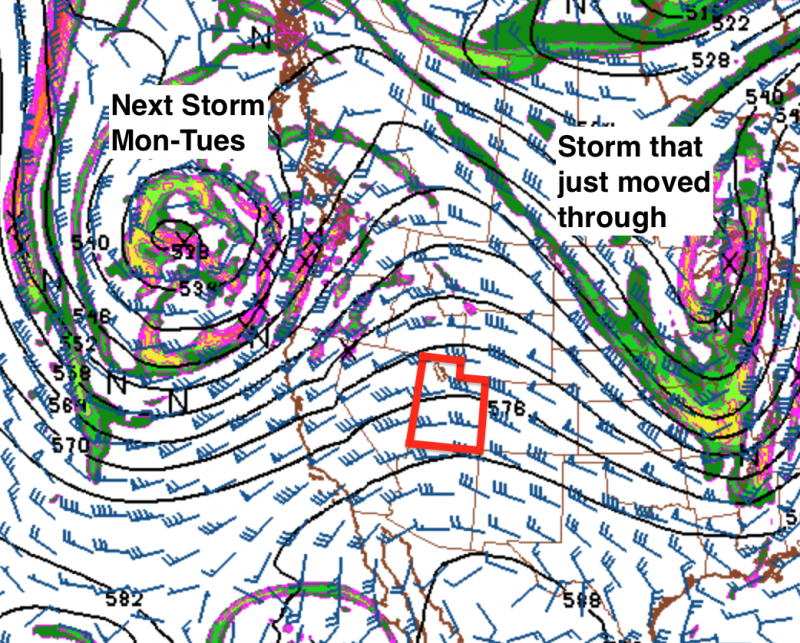
current conditions We've had a few small storms earlier in September, October and November. Not much snow stuck around from these storms. Most of it melted off aside from a few inches on the highest northerly terrain. Below is a quick video from the top of the Big Horseshoe that I shot on Wednesday, just before the most recent storm. Horseshoe Mtn early season snow. from Brett Kobernik on Vimeo. The temperatures really dropped off during the storm on Thursday. Along the ridgetops, they dipped into the single digits Friday night. We picked up around 8 inches of snow at the Mammoth-Cottonwood Snotel site which is located at the top of Fairview Canyon. For most of us, there really isn't enough snow cover for winter recreation at this time. |
| type | aspect/elevation | characteristics |
|---|

|
|
LIKELIHOOD
 LIKELY
UNLIKELY
SIZE
 LARGE
SMALL
TREND
 INCREASING DANGER
SAME
DECREASING DANGER
|
|
description
We are always concerned about old layers of weak snow which any new snow falls on. The old weak layers under the new snow often are the cause of avalanches. The small amount of old snow on the highest north facing slopes won't act as a weak layer at this time. We will continue to intently watch the snowpack, keeping an eye on any weak snow which may form prior to future storms. |
 |
weather High pressure will move in for the weekend with clear skies and daytime ridgetop high temperatures in the low 40s. We have another storm that looks like it will add some more snow Monday into Tuesday. Currently, it looks like it might add another 4 to 8 inches of snow in the high country. Ridgetop temperatures will be in the low 20s during this storm.
|
| general announcements We will publish full detailed advisories Saturday and Sunday mornings by 7am. We will also be publishing basic avalanche danger ratings & info during the week. If you are getting out into the mountains, we love to hear from you! You can SUBMIT OBSERVATIONS ONLINE or EMAIL US If you would like to have avalanche advisories emailed to you, SIGN UP HERE We can provide basic avalanche awareness presentations for your school, group or club. To enquire, CLICK HERE |


 I stopped by to see Jared
  and his crew at Big Pine Sports the other day. They have a nice looking row of new sleds just waiting for winter! Big Pine has been a long time supporter of the Utah Avalanche Center. We'll be doing an avalanche awareness talk at the shop soon. Stay tuned for the exact date and time.