25th Annual Black Diamond Fall Fundraising Party
Thursday, September 13; 6:00-10:00 PM; Black Diamond Parking Lot
25th Annual Black Diamond Fall Fundraising Party
Thursday, September 13; 6:00-10:00 PM; Black Diamond Parking Lot
| Advisory: Salt Lake Area Mountains | Issued by Evelyn Lees for Tuesday - April 10, 2018 - 6:07am |
|---|

|
bottom line The avalanche danger is MODERATE today for triggering unusually long running, wet loose sluffs on both steep and low angle slopes at mid and upper elevations. Natural wet loose avalanches are expected as the day heats up. Early starts and early finishes – once the snow heats, get out of the backcountry, avoiding travel on or below steep slopes and gullies. Unusual conditions: a slick icy bed surface below about 10,000’ allows even small sluffs to pick up snow all the way down on to the flats, potentially plowing into a person hundreds of feet below you, and burying them under 6 feet of debris. Be very aware of people above and below you.
|
 |
special announcement Snowbird will be firing upon the White Pine ridge at 7:30 am and 9:15 am this morning, April 10th. The last regular early morning forecast will be Sunday, April 17th. We will then do intermittent forecast through May 29th. The Wilderness Medicine Program at the University of Utah is surveying the knowledge of both regular and occasional backcountry users. Please provide your input through this survey. https://www.surveymonkey.com/r/AvalancheSafetySkillsSurvey |
 |
current conditions Skies are mostly clear, and temperatures are warm – in the thirties at the mid elevations, with twenties at the upper elevations and in the canyon bottoms, where the cold air has pooled. The winds have shifted to the southwest and are light, averaging 5 to10 mph at the mid elevations, and 15 to 25 mph on the highest peaks. Many slopes will be sun crusted this morning. Snow conditions are tricky - Saturday’s rain froze into a glassy ice crust below about 10,000’, and the 3 to 10” of graupel bonded poorly to the slick crusts on some slopes. Be prepared for unusually hard “slide for life” conditions as you travel through elevations below about 10,000’. The crust is much less slick above about 10,000’, with better bonding found on some upper elevation shady slopes. |
 |
recent activity Upper Little Cottonwood: yesterday, several long running, wet loose sluffs were triggered around 9,500’, mid day as the snow started to heat – Cardiff, Binx/Emma 1 and Toledo, including one person taking a ride through small trees. Earlier in the morning, artillery released some long running, narrow slides starting at higher elevations and resorts reported sensitive cornices. Natural wet loose sluffs occurred with daytime heating. 04/9/2018 Salt Lake region: Avalanche: Emma Ridges, Skier trigger 04/9/2018 Salt Lake region: Avalanche: Cardiff Bowl, Skier trigger - 13" deep - 100' wide 04/9/2018 Salt Lake region: Avalanche: Toledo Bowl, Skier trigger - 4" deep - 30' wide Left: Toledo Bowl - this slide started on a 27 degree slope and ran 600' vertical feet. Eric Shmookler photo, Right: wet debris, Cardiff, Stewart photo.
|
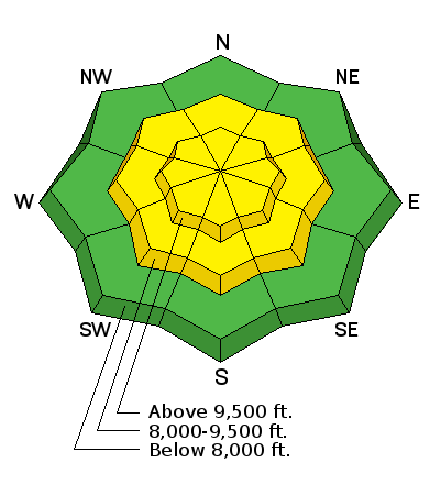
| type | aspect/elevation | characteristics |
|---|

|

|
LIKELIHOOD
 LIKELY
UNLIKELY
SIZE
 LARGE
SMALL
TREND
 INCREASING DANGER
SAME
DECREASING DANGER
|
|
description
Today’s sun will rapidly heat the snow and both human triggered and natural wet loose sluffs will be common. The wet sluffs will be easy to trigger, remarkably long running and can start on abnormally low angle slopes less steep than 30 degrees. That’s because beneath Sunday’s new snow is a slick, icy bed surface, especially around 9,500’. As the sluffs cruise downhill on this slick crust, they can entrain snow top to bottom, creating deep cement-like debris piles for such narrow slides, especially where channeled into gullies or stopping on the flats. High thin clouds are forecast to move in this afternoon, which may heat the snow on the northerly facing slopes, too. |
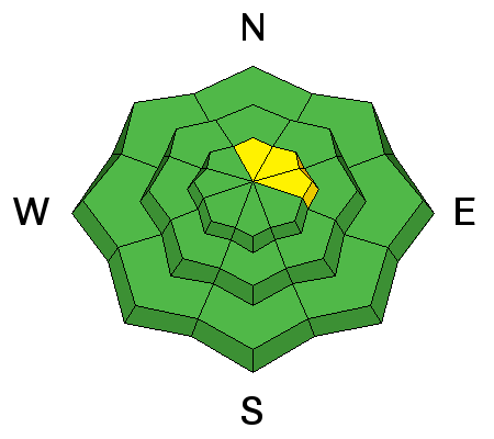
| type | aspect/elevation | characteristics |
|---|

|
|
LIKELIHOOD
 LIKELY
UNLIKELY
SIZE
LARGE
SMALL
TREND
 INCREASING DANGER
SAME
DECREASING DANGER
|
|
description
Dry loose sluffs can be triggered on steep, shady slopes, possibly running far with the hard crusts beneath. Cornices/wind drifts: Yesterday, cornices were sensitive to people along higher ridgelines. Also look for cracking and avoid drifts along ridgelines and where the graupel has pooled below cliffs. Wet slabs and glide avalanches occurred during the rain on Saturday. The issue and the weak layers are not gone, rather they are currently dormant with the colder temperatures and avalanching on these deeper weak layers is unlikely until the next prolonged warm up. |
 |
weather Another beautiful morning, though the day will rapidly get too hot. Clear skies this morning, with high thin clouds moving in this afternoon. Temperatures will warm to near 60°F at 8,000’ and into the 40s at 10,000’. The southwesterly winds will average 5 to 15 mph at the mid elevations, and up to 25 mph at the upper elevations, increasing slightly this afternoon. A quick moving cold front may drop a trace to an inch of snow overnight, with a more significant storm system expected Thursday into Friday, with much colder temperatures and potentially heavy snowfall. |
| general announcements CLICK HERE FOR MORE GENERAL INFO AND FAQ The UAC has new support programs with Outdoor Research and Darn Tough. Support the UAC through your daily shopping. When you shop at Smith's, or online at Outdoor Research, REI, Backcountry.com, Darn Tough, Patagonia, NRS, Amazon, eBay a portion of your purchase will be donated to the FUAC. See our Donate Page for more details on how you can support the UAC when you shop. Benefit the Utah Avalanche Center when you buy or sell on eBay - set the Utah Avalanche Center as a favorite non-profit in your eBay account here and click on eBay gives when you buy or sell. You can choose to have your seller fees donated to the UAC, which doesn't cost you a penny This information does not apply to developed ski areas or highways where avalanche control is normally done. This advisory is from the U.S.D.A. Forest Service, which is solely responsible for its content. This advisory describes general avalanche conditions and local variations always occur. |


