25th Annual Black Diamond Fall Fundraising Party
Thursday, September 13; 6:00-10:00 PM; Black Diamond Parking Lot
25th Annual Black Diamond Fall Fundraising Party
Thursday, September 13; 6:00-10:00 PM; Black Diamond Parking Lot
| Advisory: Salt Lake Area Mountains | Issued by Evelyn Lees for Monday - April 9, 2018 - 6:38am |
|---|

|
bottom line The avalanche danger is MODERATE for triggering very long running, dry loose sluffs on steep and low angle slopes of all aspects and elevations, especially below about 10,000’. With sun and warming temperatures, the danger of wet loose sluffs will increase to MODERATE on steep sunny slopes when the snow heats. Unusual conditions: with such a slick icy bed surface, even a small sluffs can pick up snow all the way down on to the flats, potentially plowing into a person hundreds of feet below you, and burying them under 6 feet of debris. Be very aware of people above and below you.
|
 |
special announcement The UAC Marketplace is still open. Our online marketplace still has deals on skis, packs, airbag packs, beacons, snowshoes, soft goods and much more. |
 |
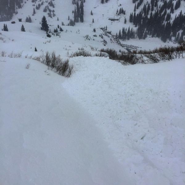
current conditions Skies are mostly clear, and temperatures have cooled nicely into the 20s at the mid and low elevations, with even a few teens up high. The northwesterly winds are decreasing, now averaging 10 to 15 mph at the mid elevations, and 25 to 30 mph on the highest peaks. Another 2 to 3 inches of snow fell overnight, bringing upper elevation storm totals in the Cottonwoods to around 10” of snow. The snow conditions are about as strange as they’ve gotten recently - Saturday’s rain froze into a glassy, slick ice crust on all aspects below about 10,000’, now covered with 3 to 10” of poorly bonded loose graupel. The crust is less slick above about 10,000’. Be prepared for unusually hard “slide for life” conditions as you travel through elevations below about 10,000’ – even ski crampons struggled on the steepest slopes and side hills. Evelyn Lees photo – icy patch work, 9,500’.
|
 |
recent activity Big and Little Cottonwood: yesterday, below about 10,000’, there were easily triggered, narrow long running sluffs. These sluffs would cruise downhill on the slick ice crust, entraining snow top to bottom, creating deep debris piles for such narrow slides. They were starting on absurdly low angles – 20 degrees – and running onto the flats. Yesterday's observations HERE. Todd Glew photos
|
| type | aspect/elevation | characteristics |
|---|

|
|
LIKELIHOOD
 LIKELY
UNLIKELY
SIZE
 LARGE
SMALL
TREND
 INCREASING DANGER
SAME
DECREASING DANGER
|
|
description
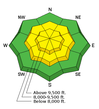
In the trio of slab, weak layer and bed surface, rarely do we focus on the bed surface. But it is THE big player today. Dry loose sluffs will again be easy to trigger on the slick, icy surface below about 10,000’, with 9500’ seeming to be the bulls-eye for the slickest ice. These can be triggered on very low angle slopes and run long distances on to the flats. If you get caught up in a sluff, you too will slide, and it may be almost impossible to stop. I honestly don’t know if or when the graupel will bond to the ice crusts. Wind slabs: Yesterday, the graupel was loose, and even in wind affected terrain, there were no wind slabs. After a night of steady northwesterly winds, there may be some wind drifts, which would be wider and larger slides if triggered. Look for cracking in drifts along ridgelines and where the graupel has pooled below cliffs and on lower angle terrain. Toledo Bowl debris pile, onto summer road and standard Cardiff up track.
|
| type | aspect/elevation | characteristics |
|---|

|
|
LIKELIHOOD
 LIKELY
UNLIKELY
SIZE
LARGE
SMALL
TREND
 INCREASING DANGER
SAME
DECREASING DANGER
|
|
description
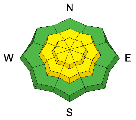
The forecast of clear skies, direct sun and warming temperatures could make the graupel on steep sunny slopes easier to trigger, and natural sluffs possible. Debris piles would be more cement-like and more dangerous. Wet slabs and glide avalanches occurred during the rain on Saturday. The issue and the weak layers are not gone, rather they are currently dormant with the colder temperatures and avalanching on these deeper weak layers is unlikely until the next warm up. Check out Mark White's Broad's Fork observations HERE and HERE. |
 |
weather It should be a stunning day, with clear skies and decreasing winds. Temperatures will warm to near 40°F at 8,000’ and into the 30s at 10,000’. The northwesterly winds are forecast to drop into the 5 to 10 mph range at the mid elevations, and to around 25 mph at the highest elevation. Sunny skies and warmer temperatures on Tuesday, with a few snow showers possible Tuesday night. A more significant storm system is expected Thursday into Friday, with much colder temperatures and potentially heavy snowfall. |
| general announcements CLICK HERE FOR MORE GENERAL INFO AND FAQ The UAC has new support programs with Outdoor Research and Darn Tough. Support the UAC through your daily shopping. When you shop at Smith's, or online at Outdoor Research, REI, Backcountry.com, Darn Tough, Patagonia, NRS, Amazon, eBay a portion of your purchase will be donated to the FUAC. See our Donate Page for more details on how you can support the UAC when you shop. Benefit the Utah Avalanche Center when you buy or sell on eBay - set the Utah Avalanche Center as a favorite non-profit in your eBay account here and click on eBay gives when you buy or sell. You can choose to have your seller fees donated to the UAC, which doesn't cost you a penny This information does not apply to developed ski areas or highways where avalanche control is normally done. This advisory is from the U.S.D.A. Forest Service, which is solely responsible for its content. This advisory describes general avalanche conditions and local variations always occur. |


.jpeg)
.jpeg)