25th Annual Black Diamond Fall Fundraising Party
Thursday, September 13; 6:00-10:00 PM; Black Diamond Parking Lot
25th Annual Black Diamond Fall Fundraising Party
Thursday, September 13; 6:00-10:00 PM; Black Diamond Parking Lot
| Advisory: Salt Lake Area Mountains | Issued by Evelyn Lees for Sunday - April 1, 2018 - 6:04am |
|---|

|
bottom line The avalanche danger is generally LOW this morning, but may rise to MODERATE with daytime heating. Wet loose sluffs will become easy to trigger on steep slopes when the snow heats. Early starts and early finishes is the springtime mantra. In steep, upper elevation northerly through easterly facing slopes, shallow wind drifts can be triggered in very isolated places and there remains a very slight chance of triggering a deep slab avalanche. Slopes that are rocky or shallower snowpack, especially terrain that avalanched one or more times this winter, are most suspect.
|
 |
special announcement The newest issue of the Powder Cloud, the newsletter of the Utah Avalanche Center, is hot off the digital presses. You can look at new and old issues of the Powder Cloud, other essays, and blogs in the menu above or click here.
The UAC Marketplace is still open. Our online marketplace still has deals on skis, packs, airbag packs, beacons, snowshoes, soft goods and much more. |
 |
current conditions Skies are mostly clear, with the huge full moon out there. Temperatures are a repeat of yesterday morning – in the 20s at the upper elevations and 30s at the low and mid elevations. And once again, there are a few readings in the 40s at the lowest elevations of the Park City, Ogden and Provo area mountains. The snow surface has a decent refreeze this morning at all but the lower elevations. The westerly winds are averaging 10 to 15 mph at the mid elevations, with the high peaks averaging to 25 mph. There should be another good window for corn today when the smooth, sunny slopes first soften and there is some soft, recrystallized powder on upper northerly facing slopes in wind-sheltered terrain. There are widespread icy crusts on most aspects and elevations early in the day, some which may not soften, so be prepared for hard, “slide for life” conditions in steep terrain. Ice axes, crampons and ski crampons may be appropriate for steep objectives. Mark White photo – icy surface snow.
|
 |
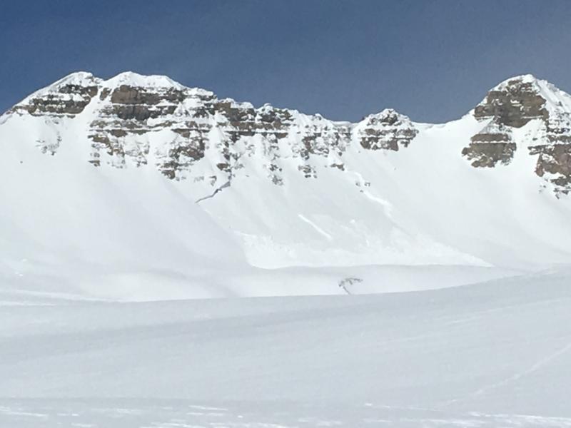
recent activity Clouds and wind won the battle with the sun yesterday and kept the snow cool, and there were only a few reports of minor wet loose activity. There may have been a shallow, wet slab on the Park City side, seen from a distance, on an east facing slope around 9000’. Of more interest were 3 large slides off of Timpanogos – timing unknown. Timp photo below: Dave Martin. The NE side of Box Elder also has a huge crown – again, timing unknown.
|
| type | aspect/elevation | characteristics |
|---|

|
|
LIKELIHOOD
 LIKELY
UNLIKELY
SIZE
 LARGE
SMALL
TREND
 INCREASING DANGER
SAME
DECREASING DANGER
|
|
description
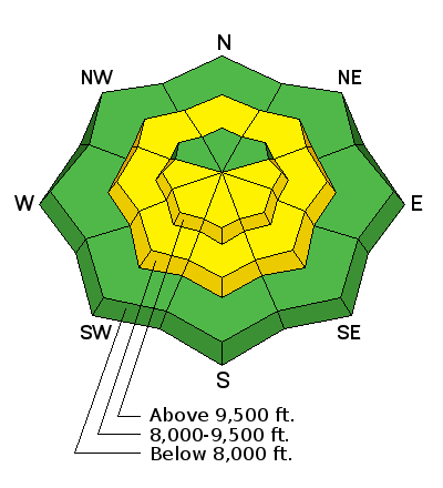
Clear skies and lots of direct sun are in the forecast today, so the snow’s overnight refreeze will be shorter lived, especially at the low and mid elevations. When the sun hits a slope in full force, the snow surface will heat and wet loose sluffs will become easy to trigger. Once the snow becomes wet and loose, it’s time to get off of and out from under steep slopes, and move to a cooler aspect or lower angle terrain. |
| type | aspect/elevation | characteristics |
|---|

|
|
LIKELIHOOD
 LIKELY
UNLIKELY
SIZE
 LARGE
SMALL
TREND
 INCREASING DANGER
SAME
DECREASING DANGER
|
|
description
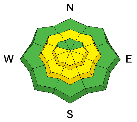
The avalanche hazard is generally Low and avalanches are unlikely. But travel in avalanche terrain is never a completely safe game, so watch for the following issues on isolated features: Wind slabs: there isolated wind drifts that could be triggered by a person – northerly and easterly facing slopes in the highest alpine terrain are the most suspect. Quickly dig down and search for the potential weak layer - loose graupel beneath the surface snow. Deep slab: If you’re wondering what happened to the Deep Slab avalanche problem, catch up with Mark’s great video below. The issue and the weak layers are not gone, rather they are currently dormant and avalanching on these deeper weak layers is unlikely. Glide avalanches: full depth releases can happen on slopes with smooth rock slabs beneath – Stairs Gulch, Broads Fork and Raymond have examples of this terrain. |
 |
weather It’s another beautiful warm spring day, with clear skies and lots of sun. Temperatures will warm to near 50°F at 8,000’ today and close to 40°F at 10,000’. The west to northwesterly wind are forecast to average in the 10 to 20 mph range at the mid elevations, and 25 to 35 mph at the highest elevation. Increasing clouds and southwesterly winds overnight and tomorrow, ahead of a small storm that could drop 2 to 4” of snow Monday night. Then back to warm and dry weather through Friday |
| general announcements CLICK HERE FOR MORE GENERAL INFO AND FAQ The UAC has new support programs with Outdoor Research and Darn Tough. Support the UAC through your daily shopping. When you shop at Smith's, or online at Outdoor Research, REI, Backcountry.com, Darn Tough, Patagonia, NRS, Amazon, eBay a portion of your purchase will be donated to the FUAC. See our Donate Page for more details on how you can support the UAC when you shop. Benefit the Utah Avalanche Center when you buy or sell on eBay - set the Utah Avalanche Center as a favorite non-profit in your eBay account here and click on eBay gives when you buy or sell. You can choose to have your seller fees donated to the UAC, which doesn't cost you a penny This information does not apply to developed ski areas or highways where avalanche control is normally done. This advisory is from the U.S.D.A. Forest Service, which is solely responsible for its content. This advisory describes general avalanche conditions and local variations always occur. |


.JPG)