25th Annual Black Diamond Fall Fundraising Party
Thursday, September 13; 6:00-10:00 PM; Black Diamond Parking Lot
25th Annual Black Diamond Fall Fundraising Party
Thursday, September 13; 6:00-10:00 PM; Black Diamond Parking Lot
| Advisory: Salt Lake Area Mountains | Issued by Drew Hardesty for Thursday - March 29, 2018 - 5:57am |
|---|

|
bottom line A MODERATE danger exists for areas of wind drifts on many slopes in the mid and upper elevations. Watch for cross-loading onto other aspects and around other terrain features. Avoid the steep sunny aspects by midday and afternoon as they may become wet and unstable.
|
 |
special announcement The newest issue of the Powder Cloud, the newsletter of the Utah Avalanche Center is hot off the presses. You can always grab a cup of coffee and while away the time waiting for the winds to subside by looking at new and old issues of the Powder Cloud, other essays, and blogs. Look for them in the menu above or click here.
Only a few more days to support the UAC when you shop at Whole Foods. The Whole Foods Bag Donation ends Saturday March 31. When you bring your own bags to Whole Foods in Sugar House, Trolley Square, and Cottonwood Heights you can choose to have the UAC be the recipient of your 10 cent bag credit. The UAC Marketplace is still open. Our online marketplace still has deals on skis, packs, airbag packs, beacons, snowshoes, soft goods and much more. Tonight - PC Pro Ski Patrol Association BC Bow Wow at OP Rockwell
|
 |
current conditions Wind and more wind. It's a good lesson in impermanence. Skies are partly cloudy with mountain temperatures in the mid-20s. West to northwest winds are still moderate to strong, blowing 20-25mph with gusts to 40. The highest peaks and ridgelines have speeds in the 45-55mph range with gusts to 70. Even base areas have gusts to 20+. Some areas picked up a trace to an inch of graupel with localized areas sporting a touch of rime. Mark got out to White Pine yesterday and well summarizes the state of the snowpack. Check his excellent observation here. |
 |
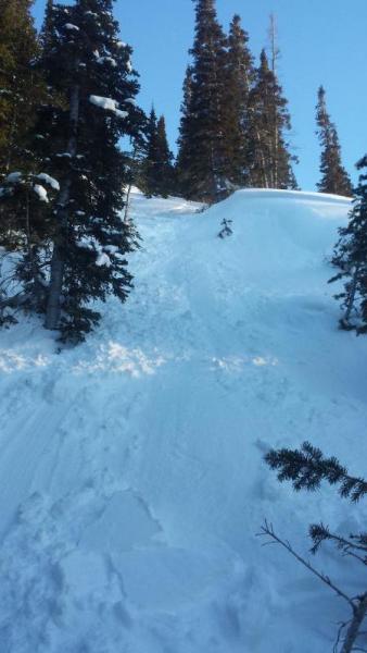
recent activity The winds even deposited shallow wind drifts in the mid-elevations and otherwise semi-protected areas. One skier in west Scottie's of LCC triggered and was briefly caught and carried in one of these shallow wind pockets but otherwise ended up ok (pic below). The wind drifts was 6" deep and 25' wide on a north facing slope at 9200'. He submitted a quick write-up here. Thanks for the info -
|
| type | aspect/elevation | characteristics |
|---|

|
|
LIKELIHOOD
 LIKELY
UNLIKELY
SIZE
 LARGE
SMALL
TREND
 INCREASING DANGER
SAME
DECREASING DANGER
|
|
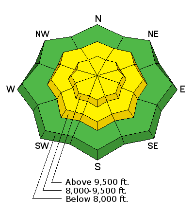
description
Pockets of soft and hard wind drifts are now scattered across the range and may be found on many slopes. Look for slightly rounded, smooth pillows and areas with more of a scalloped appearance. Remember that with soft slabs, you're "in" the snow; for hard slabs, you're "on top of" it. Hard slabs have a nasty habit - I think Ev likes to say - of pulling out above you, further narrowing your margin for escape. Treat wind damaged terrain with suspicion today. The wild card - the near bullet-proof rain crust from March 22nd sits beneath some potential weak layers of graupel and small grained facets. I am interested to know if the additional wind loading may allow any triggered drifts to step down another 10" or so to this excellent bed surface. Greg Gagne and I both have more info on this layering - here and here. |
| type | aspect/elevation | characteristics |
|---|

|
|
LIKELIHOOD
 LIKELY
UNLIKELY
SIZE
 LARGE
SMALL
TREND
 INCREASING DANGER
SAME
DECREASING DANGER
|
|
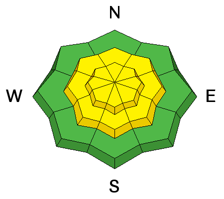
description
We feel that the deep slab issues are trending toward dormancy and human triggered slides are very unlikely. The rain event from last week might prove to be short-term pain, long term gain. By this I mean to imply that while Thursday/Friday's storm greatly stressed the snowpack and produced both wet slabs and localized areas of deep slabs, it has since created a stout bridge up to perhaps 10,000' on all aspects. The mid-pack and basal weaknesses continue to adjust and gain strength. Mark's video above helps to demonstrate our thinking with this. |
| type | aspect/elevation | characteristics |
|---|

|

|
LIKELIHOOD
 LIKELY
UNLIKELY
SIZE
 LARGE
SMALL
TREND
INCREASING DANGER
SAME
DECREASING DANGER
|
|
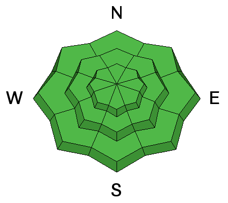
description
Remember that risk is inherent in mountain travel. One can never diminish it entirely and for some of us this is part of the attraction. The allure. That the outcome is uncertain. But we can travel in appropriate terrain. And strive to understand snow and avalanches. Dial in the rescue protocol. Work to understand our own and our partners' weaknesses and blindspots. But the world is as it is and it's our destiny to move with that rather than shape it to our own desires and convenience, as this otherwise only brings about all manner of paradox and difficulty. With that - Cornices continue to be suspect along the ridgelines. Shallow damp push-alanches may be possible with daytime warming, particularly in low to mid-elevation wind protected sunlit terrain. Full depth glide releases are to be considered in the Big Cottonwood drainages of Stairs, Broads, and Mill B South. Slide-for-life conditions from last week's rain event also exist in some steep terrain. |
 |
weather For today we'll have partly cloudy skies with 8 and 10,000' temps rising to the in the mid-30s and mid-20s, respectively. The northwest winds should start to lose steam by late morning. With a warming trend, ridgetop "free air" temps move toward freezing and beyond (mid to upper 30s) by Sunday. A ridge of high pressure parked off the west coast will keep us under a slowly warming northwest flow for a couple of days until, battered and bruised by near continual storms, it flattens or retrogrades a bit, allowing for more disturbances to move through. None look all that impressive at this time, but it may open the door for something in the near future. Keep an eye on those models. I'm not so sure we're done with winter. |
| general announcements CLICK HERE FOR MORE GENERAL INFO AND FAQ The UAC has new support programs with Outdoor Research and Darn Tough. Support the UAC through your daily shopping. When you shop at Smith's, or online at Outdoor Research, REI, Backcountry.com, Darn Tough, Patagonia, NRS, Amazon, eBay a portion of your purchase will be donated to the FUAC. See our Donate Page for more details on how you can support the UAC when you shop. Benefit the Utah Avalanche Center when you buy or sell on eBay - set the Utah Avalanche Center as a favorite non-profit in your eBay account here and click on eBay gives when you buy or sell. You can choose to have your seller fees donated to the UAC, which doesn't cost you a penny This information does not apply to developed ski areas or highways where avalanche control is normally done. This advisory is from the U.S.D.A. Forest Service, which is solely responsible for its content. This advisory describes general avalanche conditions and local variations always occur. |