25th Annual Black Diamond Fall Fundraising Party
Thursday, September 13; 6:00-10:00 PM; Black Diamond Parking Lot
25th Annual Black Diamond Fall Fundraising Party
Thursday, September 13; 6:00-10:00 PM; Black Diamond Parking Lot
| Advisory: Salt Lake Area Mountains | Issued by Drew Hardesty for Wednesday - March 28, 2018 - 5:34am |
|---|

|
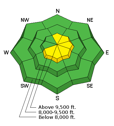
bottom line Many areas continue to have an overall LOW avalanche danger. A MODERATE danger now exists for new and developing wind drifts primarily in steep north through east through south facing slopes above about 9000'. Watch for cross-loading onto other aspects and around other terrain features. The smart money today heads for lower angle wind and sun sheltered terrain.
|
 |
special announcement Only 1 more week to support the UAC when you shop at Whole Foods. The Whole Foods Bag Donation ends March 31. When you bring your own bags to Whole Foods in Sugar House, Trolley Square, and Cottonwood Heights you can choose to have the UAC be the recipient of your 10 cent bag credit. The UAC Marketplace is still open. Our online marketplace still has deals on skis, packs, airbag packs, beacons, snowshoes, soft goods and much more.
|
 |
current conditions Yesterday's glory is now a thing of the past. A warm front and its attendant cloud cover, light snow, possible rime, and moderate to strong winds moved through overnight and Trent's Tuesday of clear, cold, and crisp is now warm and humid with dastardly winds. Temps are in the mid-20s and the northwest winds are 15-20mph with gusts to 30-40. The most exposed anemometers have hourly averages of 40-50mph with gusts to 60-70. It looks like one gust was over 90mph in the early hours after midnight. Skiing and riding conditions have been nothing short of sublime these last few days, but now you'll rattle through breakable sun crusts and wind damage, if not sensitive wind slabs up high if you're not careful. Wind protected mid elevations will be the right call for today. Check out windy.com's wind forecasts for Utah... |
 |
recent activity The wet activity stayed mostly glued-in yesterday; however a wet loose sluff off the Ivory Tower in Cardiff Fork crossed the uptrack on the steep southeast facing portion of the ridge. Minor dry loose sluffs also noted to move with provocation on the steepest northerly terrain. Mark White went into Broads Fork of BCC yesterday to see about recent glide avalanche activity and he wasn't disappointed. He found a number of big game trophy sized full depth glide avalanches that left impressive debris piles from probably Friday, post Equinox rain event. You'll see a photo below, but it's worth checking out his observations. You can find more about glide avalanches below. 03/27/2018 Observation: Broads Fork Salt Lake region mark white 03/23/2018 Salt Lake region: Avalanche: Diving Board, Natural trigger - 10' deep - 500' wide
|
| type | aspect/elevation | characteristics |
|---|

|
|
LIKELIHOOD
 LIKELY
UNLIKELY
SIZE
 LARGE
SMALL
TREND
 INCREASING DANGER
SAME
DECREASING DANGER
|
|
description
Areas of Wind Slab. The light, cold, dry snow will move readily with the moderate to strong west to northwest winds and - perhaps being drifted on a collapsible and weak snow surface - may be surprisingly sensitive. Some wind drifts may be triggered from a distance. The drifts will be more prominent along the higher, more exposed north through east through south facing slopes but watch for cross-loading around terrain features on other aspects. The wild card - the near bullet-proof rain crust from March 22nd sits beneath some potential weak layers of graupel and small grained facets. I am interested to know if the additional wind loading may allow any triggered drifts to step down another 10" or so to this excellent bed surface. Greg Gagne and I both have more info on this layering - here and here. |
| type | aspect/elevation | characteristics |
|---|

|
|
LIKELIHOOD
 LIKELY
UNLIKELY
SIZE
 LARGE
SMALL
TREND
 INCREASING DANGER
SAME
DECREASING DANGER
|
|
description
We feel that the deep slab issues are trending toward dormancy and human triggered slides are very unlikely. The rain event from last week might prove to be short-term pain, long term gain. By this I mean to imply that while Thursday/Friday's storm greatly stressed the snowpack and produced both wet slabs and localized areas of deep slabs, it has since created a stout bridge up to perhaps 10,000' on all aspects. The mid-pack and basal weaknesses continue to adjust and gain strength. |
| type | aspect/elevation | characteristics |
|---|

|

|
LIKELIHOOD
 LIKELY
UNLIKELY
SIZE
 LARGE
SMALL
TREND
 INCREASING DANGER
SAME
DECREASING DANGER
|
|
description
Remember that risk is inherent in mountain travel. One can never diminish it entirely and for some of us this is part of the attraction. The allure. That the outcome is uncertain. But we can travel in appropriate terrain. And strive to understand snow and avalanches. Dial in the rescue protocol. Work to understand our own and our partners' weaknesses and blindspots. But the world is as it is and it's our destiny to move with that rather than shape it to our own desires and convenience, as this otherwise only brings about all manner of paradox and difficulty. With that, consider cornices to continue to be suspect along the ridgelines. Shallow damp push-alanches may be possible with daytime warming. Full depth glide releases are to be considered in the Big Cottonwood drainages of Stairs, Broads, and Mill B South. Slide-for-life conditions from last week's rain event also exist in some steep terrain. |
 |
weather With the warm front, we can expect periods of light snowfall and perhaps some riming today. Mountain temps will rise to the mid-30s at the mid-elevations. The west to northwest winds are expected to blow 30-40mph with gusts to 50+. Clouds should start to thin out in the valleys but hang around in the mountains...and then become partly cloudy for the next few days. |
| general announcements CLICK HERE FOR MORE GENERAL INFO AND FAQ The UAC has new support programs with Outdoor Research and Darn Tough. Support the UAC through your daily shopping. When you shop at Smith's, or online at Outdoor Research, REI, Backcountry.com, Darn Tough, Patagonia, NRS, Amazon, eBay a portion of your purchase will be donated to the FUAC. See our Donate Page for more details on how you can support the UAC when you shop. Benefit the Utah Avalanche Center when you buy or sell on eBay - set the Utah Avalanche Center as a favorite non-profit in your eBay account here and click on eBay gives when you buy or sell. You can choose to have your seller fees donated to the UAC, which doesn't cost you a penny This information does not apply to developed ski areas or highways where avalanche control is normally done. This advisory is from the U.S.D.A. Forest Service, which is solely responsible for its content. This advisory describes general avalanche conditions and local variations always occur. |


.JPG)