25th Annual Black Diamond Fall Fundraising Party
Thursday, September 13; 6:00-10:00 PM; Black Diamond Parking Lot
25th Annual Black Diamond Fall Fundraising Party
Thursday, September 13; 6:00-10:00 PM; Black Diamond Parking Lot
| Advisory: Salt Lake Area Mountains | Issued by Evelyn Lees for Sunday - March 25, 2018 - 6:26am |
|---|

|
bottom line The avalanche danger is MODERATE at the upper elevations and on all steep, wind drifted slopes. These Wind Slabs will be most widespread on northerly facing slopes. Shallow, loose sluffs can be triggered in the same terrain. There is also a MODERATE danger for the isolated chance of triggering a Deep Slab avalanche 2 to 5 feet deep on northerly through easterly facing slopes at the upper elevations. Slopes that are rocky or have a shallower snowpack are most suspect, especially in terrain that has slid one or more times this year.
|
 |
special announcement Only 1 more week to support the UAC when you shop at Whole Foods. The Whole Foods Bag Donation ends March 31. When you bring your own bags to Whole Foods in Sugar House, Trolley Square, and Cottonwood Heights you can choose to have the UAC be the recipient of your 10 cent bag credit. The UAC Marketplace is still open. Our online marketplace still has deals on skis, packs, airbag packs, beacons, snowshoes, soft goods and much more. |
 |
current conditions Skies are cloudy this morning, and temperatures dropped into the twenties and teens at most mountain stations, cooler than yesterday. Solid refreeze. Southerly winds are blustery – averaging 15 to 25 mph at mid elevations, gusting in the 30s. Speeds across the upper elevation ridge lines average 25 to 35 mph, with gusts to 50 mph. The Thursday/Friday drenching fast-forwarded our snowpack to mid April – melted out trail heads and created isothermal snow at the low to mid elevations, which is strong when frozen, weak when wet. Upper elevation northerly facing slopes hold the best of the cold dry, powder, with buried weak facet layers still intact. The hard icy snow will not soften for the next few days, so again, think spring - sharpen your edges, consider ice axes, crampons, whippets or ski crampons, depending on your project – “slide for life’s” are a real concern. |
 |
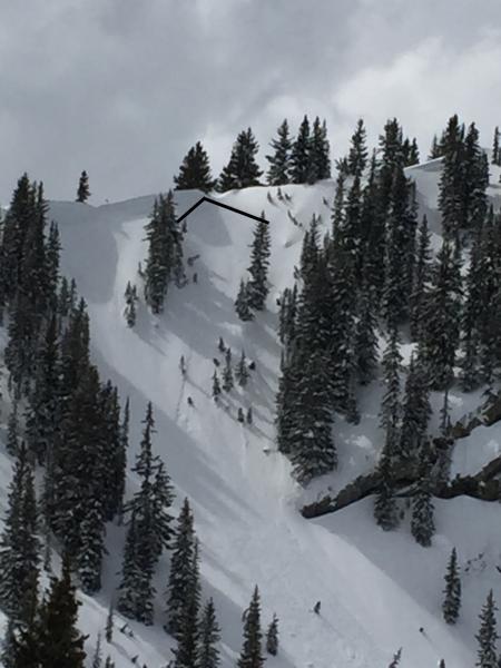
recent activity The cooler temperatures “locked up” the snowpack surprisingly fast. What had been a wet snowpack at the mid and low elevations on Thursday and Friday now has a thick strong ice crust capping it, with the wet snow beneath continuing to cool. The resorts reported no wet avalanches yesterday, even with extensive explosive testing. Shallow winds slabs, both natural and skier triggered, released on northerly facing slopes along the higher ridge lines, averaging 6 to 12” deep, and 50’ wide. One hard slab was released with explosive control work into old snow yesterday, on a northeast-facing slope at 10,100’. It was in uncompacted terrain that has produced numerous repeaters this season. Left - Larry Dun photo: natural wind slab, Silver Fork Right - Lees photo: Thursday's wet snow is today's bomber 5 inch thick ice crust, NW, 9,400’.
|
| type | aspect/elevation | characteristics |
|---|

|
|
LIKELIHOOD
 LIKELY
UNLIKELY
SIZE
 LARGE
SMALL
TREND
 INCREASING DANGER
SAME
DECREASING DANGER
|
|
description
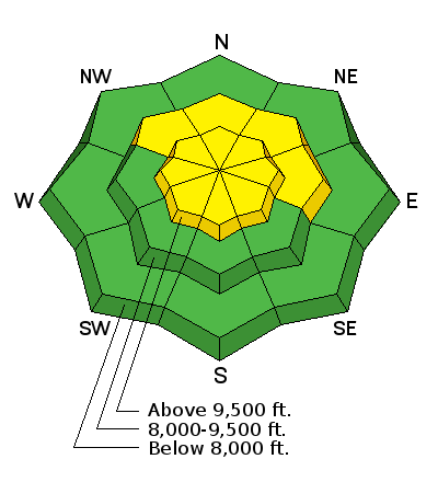
The persistent southerly winds continued to drift snow all night, mostly at the higher elevations onto northerly facing slopes. These sensitive wind slabs will be found mostly along ridge lines, but watch for some drifting on mid elevation slopes and drifts cross-loaded along gully walls and onto other aspects by the swirling winds. Dry loose sluffs can be triggered on the steepest, upper elevation northerly facing slopes today, and in gullies and below cliff bands where the where the graupel has pooled. |
| type | aspect/elevation | characteristics |
|---|

|
|
LIKELIHOOD
 LIKELY
UNLIKELY
SIZE
 LARGE
SMALL
TREND
INCREASING DANGER
SAME
DECREASING DANGER
|
|
description
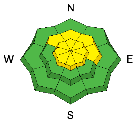
At elevations above the strong supportable crusts it is still possible to trigger a deep avalanche breaking on a weak facet layer in very isolated places. The most likely slope would be one with a shallower snow pack – such as a slope that has slid one or more times this year, or in steep, complex rocky terrain with sharp break overs. Low probability of triggering a slide, but high consequences if you do. |
 |
weather The cold front entering northwest Utah this morning will bring increasing clouds with light snow starting this afternoon. Snow totals today through Monday morning should add up to 4 to 8”. Temperatures today will remain in the 20s to low 30s, and then cool into the teens tonight. The brisk, southerly winds (averaging 15 to 25 mph at the mid elevations, 25 to 35 mph at the upper elevations) will gradually decrease through out the day, and drop even more after they shift to the northwest tonight. A few lingering snow showers on Monday, and much colder. |
| general announcements CLICK HERE FOR MORE GENERAL INFO AND FAQ The UAC has new support programs with Outdoor Research and Darn Tough. Support the UAC through your daily shopping. When you shop at Smith's, or online at Outdoor Research, REI, Backcountry.com, Darn Tough, Patagonia, NRS, Amazon, eBay a portion of your purchase will be donated to the FUAC. See our Donate Page for more details on how you can support the UAC when you shop. Benefit the Utah Avalanche Center when you buy or sell on eBay - set the Utah Avalanche Center as a favorite non-profit in your eBay account here and click on eBay gives when you buy or sell. You can choose to have your seller fees donated to the UAC, which doesn't cost you a penny This information does not apply to developed ski areas or highways where avalanche control is normally done. This advisory is from the U.S.D.A. Forest Service, which is solely responsible for its content. This advisory describes general avalanche conditions and local variations always occur. |