25th Annual Black Diamond Fall Fundraising Party
Thursday, September 13; 6:00-10:00 PM; Black Diamond Parking Lot
25th Annual Black Diamond Fall Fundraising Party
Thursday, September 13; 6:00-10:00 PM; Black Diamond Parking Lot
| Advisory: Salt Lake Area Mountains | Issued by Mark Staples for Saturday - March 24, 2018 - 6:49am |
|---|

|
bottom line Avalanche conditions are tricky and weird today. Multiple problems involving dry snow and wet snow exist. Until the snowpack has a solid refreeze, the best option is to avoid avalanche terrain by riding slopes less than 30 degrees without steeper ones above you.
|
 |
special announcement Only 1 more week to support the UAC when you shop at Whole Foods. The Whole Foods Bag Donation ends March 31. When you bring your own bags to Whole Foods in Sugar House, Trolley Square, and Cottonwood Heights you can choose to have the UAC be the recipient of your 10 cent bag credit. The UAC Marketplace is still open. Our online marketplace still has deals on skis, packs, airbag packs, beacons, snowshoes, soft goods and much more. |
 |
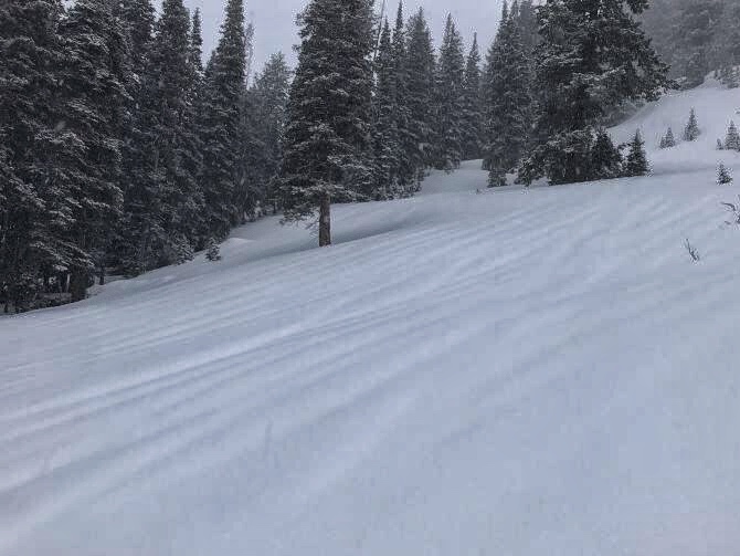
current conditions Yesterday morning 1-2 inches of additional snow fell. The sun appeared around noon and skies cleared overnight. Temperatures warmed a few degrees this morning with increased south winds and are in the mid to upper 20's F at most elevations. Winds are averaging 15-20 mph from the SSE at ridgetops and gusting 30-40 mph. Storm totals (Thursday through Friday morning) are about 2.5 inches of water in the Cottonwoods and 1.5 inches of water along the PC Ridgeline. At low elevations, this precipitation was all rain. At upper elevations it was 10-12 inches of snow. The snowpack yesterday was warm, weak and wet up to about 9500 feet. If you stepped out of your skis or board, you'd quickly sink to your waist. Clear skies and below freezing temperatures last night have likely only refrozen the snow surface. Photo below (Brackelsberg) shows runnels in the snowpack which are evidence of liquid water moving downslope in the snowpack. For a quick recap of the last seven days, check out our Week in Review
|
 |
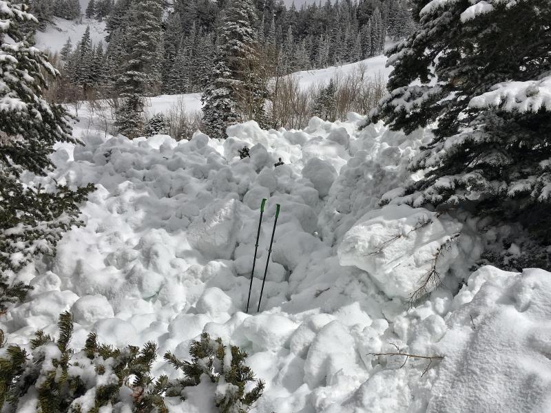
recent activity Yesterday morning at least 7 wet slab avalanches were triggered by ski patrols in the Salt Lake area mountains. Many of these were at least 2 feet deep and occurred generally between 8500 feet and 9500 feet. These are no joke. The debris is like a slurry of wet concrete. These slides were mostly triggered with small hand charges. I looked a a few of them yesterday, and there's no doubt that a skier or rider could have easily triggered them as well. Also, 2 natural deep slab avalanches involving dry snow were spotted yesterday in Day's Fork. One definitely occurred in a path that slid previously and created debris 10-15 feet deep. The other likely occurred in a repeater path as well but I'm unsure. Photo below of leg breaking wet slab debris in Little Cottonwood Canyon.
|
| type | aspect/elevation | characteristics |
|---|

|

|
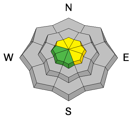
LIKELIHOOD
 LIKELY
UNLIKELY
SIZE
 LARGE
SMALL
TREND
 INCREASING DANGER
SAME
DECREASING DANGER
|
|
description
Mid elevations (mainly 8500 feet to 9500 feet) are where the greatest wet slab hazard exists because the snowpack under the new snow is totally wet and weak. The wet slab activity yesterday is a major red flag for this problem. Honestly, we really don't know much about wet slabs. Will there be more today? I have no idea. Todd Glew said it best in his observation "All the water running through the snowpack is making things weird and unpredictable until we get a solid freeze." This avalanche problem is creating dangerous avalanche conditions and I'm rating the danger CONSIDERABLE at mid elevations because:
Shallow wet loose avalanches (aka wet sluffs or point releases) should occur as the day quickly warms. These wet loose slides usually aren't a major hazard, but they are often good triggers for bigger, wet slab avalanches. |
| type | aspect/elevation | characteristics |
|---|

|
|
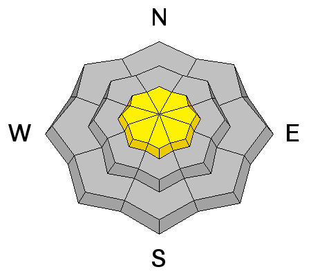
LIKELIHOOD
 LIKELY
UNLIKELY
SIZE
LARGE
SMALL
TREND
INCREASING DANGER
SAME
DECREASING DANGER
|
|
description
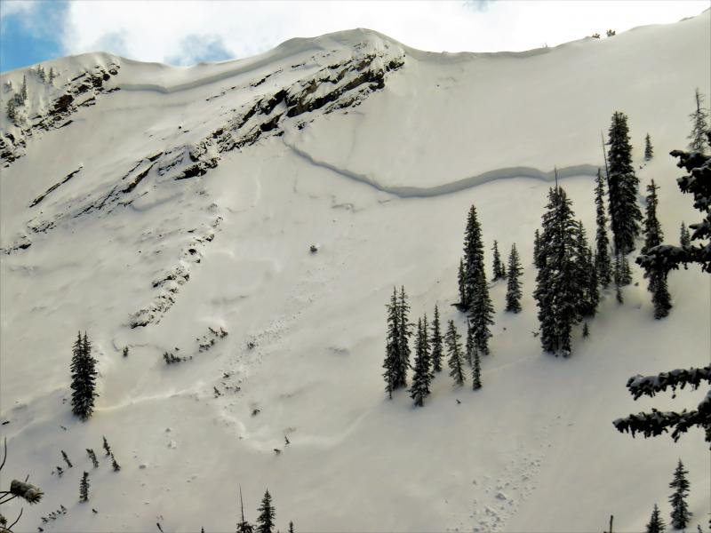
Above 9500 feet, the snowpack is dry, especially on northerly aspects. In these areas, mainly NW -> N ->E facing slopes, a deep persistent slab avalanche problem exists. The recent storm with 2.5 inches of water is a major load that is stressing faceted layers near the ground and in the middle of the snowpack near a dust layer. This type of problem is easiest to trigger in places where the snowpack is a little thinner like slopes that have avalanched previously this season or steep rocky areas where the snow depths vary a lot across a slope. This problem is much harder to trigger or doesn't exist on slopes where the snowpack is about 6 feet deep. The photo below shows an example of one these types of slides that was spotted yesterday in Days Fork. This slide was a repeater but it also occured in a steep, rocky area that would be a good place to trigger another.
|
| type | aspect/elevation | characteristics |
|---|

|
|
LIKELIHOOD
LIKELY
UNLIKELY
SIZE
 LARGE
SMALL
TREND
INCREASING DANGER
SAME
DECREASING DANGER
|
|
description
Increased south winds this morning have likely created some shallow wind slabs at the upper elevations where winds may find some dry snow to transport. Compared to wet slab and deep slab avalanches, wind slabs almost seem like child's play. The main reason is that they will be shallow. Also, you can see and avoid them. You can read more about how to identify wind slabs HERE. |
 |
weather This morning's clear skies will make way for strong sunshine. Air temperatures should rise into the mid to upper 30's F but feel a lot warmer. Winds should generally continue from the south averaging 15-20 mph at ridgetops with 30-40 mph gusts. Clouds will begin arriving this afternoon and bring some light snow showers by the end of the day and this evening. More importantly, temperatures should cool off significantly tonight. Only a trace to one inch of snow should fall tonight. A much better chance for snow comes Sunday and Monday when 6-10 inches should fall. |
| general announcements CLICK HERE FOR MORE GENERAL INFO AND FAQ The UAC has new support programs with Outdoor Research and Darn Tough. Support the UAC through your daily shopping. When you shop at Smith's, or online at Outdoor Research, REI, Backcountry.com, Darn Tough, Patagonia, NRS, Amazon, eBay a portion of your purchase will be donated to the FUAC. See our Donate Page for more details on how you can support the UAC when you shop. Benefit the Utah Avalanche Center when you buy or sell on eBay - set the Utah Avalanche Center as a favorite non-profit in your eBay account here and click on eBay gives when you buy or sell. You can choose to have your seller fees donated to the UAC, which doesn't cost you a penny This information does not apply to developed ski areas or highways where avalanche control is normally done. This advisory is from the U.S.D.A. Forest Service, which is solely responsible for its content. This advisory describes general avalanche conditions and local variations always occur. |