25th Annual Black Diamond Fall Fundraising Party
Thursday, September 13; 6:00-10:00 PM; Black Diamond Parking Lot
25th Annual Black Diamond Fall Fundraising Party
Thursday, September 13; 6:00-10:00 PM; Black Diamond Parking Lot
| Advisory: Salt Lake Area Mountains | Issued by Greg Gagne for Friday - March 23, 2018 - 3:56am |
|---|

|
bottom line A complex and uncertain setup is in place, leading to an overall Considerable avalanche hazard: (1) Storm and wind-driven snow will possibly create sensitive storm and fresh wind slabs, especially through the morning hours during any period of high precipitation intensity. (2) Over 2" of water weight over a 24-hour window has rapidly loaded the snowpack, and this may be enough to get deeper slabs reactive once again. (3) 1-2" of rain has created a wet loose avalanche problem at the low and mid elevations. During periods of uncertainty and snowpack complexity, the best option is to make things simple: The best - and safest - riding conditions today will be on low-angled slopes at the upper elevations. The dense new snow is supportable and it will be easy and fun moving on the low angles.
|
 |
special announcement Little Cottonwood Canyon is closed for control work and interlodge is in effect as of 6:30 am. A backcountry closure on the northside of Little Cottonwood extending from Lisa Falls to Grizzly Gulch. Estimated opening time of 8 am. Be sure to follow rules for all closures.
On Thursday, March 8th, two skiers were caught in an avalanche on Kessler Peak in Big Cottonwood Canyon. They were extremely lucky and were not injured or buried. An interesting component to this avalanche was how they got there in the first place. Read about it here.
There is something of a cultural change happening in our community and it's an amazing and radical transformation toward openness and reflection in regards to avalanche involvements and close calls. At our avalanche discussion at the RockSteady studio Monday night, we had 65 in attendance. At least three people involved in avalanches this winter were there to discuss their experiences. This wouldn't have happened 10-15 years ago. Drew has written about Shame before. Tom Diegel wrote another great piece here. |
 |
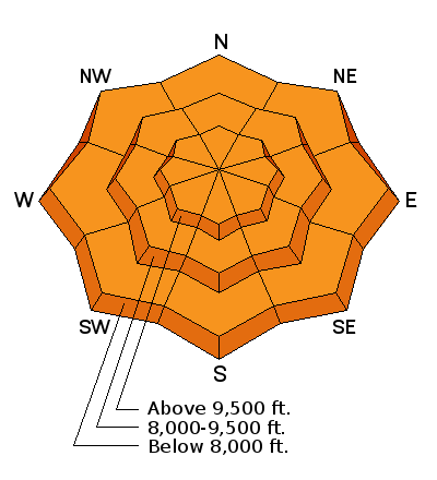
current conditions As of 6 am a cold front is finally starting to sag into our region and mountain temperatures have dropped below freezing and are in the mid to upper 20's F. Winds are westerly and overnight gusts ranged from the 30's to the 50's mph. Even at lower elevations gusts have been in the 20's and 30's, and at 11,000' gusts have been in the 70's mph. Wind speeds are fortunately on the decline. 1 to 2.25" of water (you read that correctly) has fallen in the past 24 hours. The rain/snow line has been about 9500', but has been lowering since frontal passage this morning. Above 9500' 2-4" of snow has fallen overnight, bringing storm snow totals of 2-8" at the upper elevations. Our Week in Review:
|
 |
recent activity Rain to about 9500' on Thursday led to natural wet activity at the low and mid elevations. Wet rollerballs and push-a-lanches in the wet snow on steeper slopes were also reported. UDOT Little Cottonwood avalanche forecaster Mark Sauer described Thursday quite well: "Many lovely waterfalls lower canyon...Tanners, Maybird, the climbing zones. It’s like springtime in the desert." |
| type | aspect/elevation | characteristics |
|---|

|

|
LIKELIHOOD
 LIKELY
UNLIKELY
SIZE
 LARGE
SMALL
TREND
 INCREASING DANGER
SAME
DECREASING DANGER
|
|
description
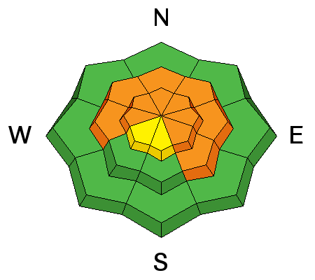
Winds are expected to diminish throughout the morning hours, and we're not expecting to get large amounts of new snow. But periods of heavy snowfall this morning may create sensitive soft slabs as well as fresh wind drifts, especially above about 9500'. Storm snow and/or wind slabs will generally be more sensitive this morning, and should stabilize during the aftenoon. |
| type | aspect/elevation | characteristics |
|---|

|
|
LIKELIHOOD
LIKELY
UNLIKELY
SIZE
 LARGE
SMALL
TREND
 INCREASING DANGER
SAME
DECREASING DANGER
|
|
description
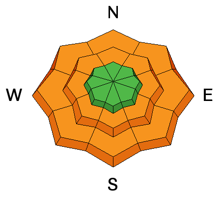
1 to 2+ inches of water over 24 hours is a rapid loading event, and with another 0.5" of water weight possible today, this may be enough to get our deep slabs reactive once again. I am especially concerned about thinner snowpack areas outside of the periphery of the Cottonwoods, as well as traditionally thinner snowpack areas such as steep, rocky terrain and slopes that have already slid this season. If you do trigger a deep slab, expect it to be 2-4' deep and over a hundred feet wide, possibly even larger. You're in this for the long run - be patient and give the snowpack time to adjust. |
| type | aspect/elevation | characteristics |
|---|

|
|
LIKELIHOOD
 LIKELY
UNLIKELY
SIZE
LARGE
SMALL
TREND
INCREASING DANGER
SAME
DECREASING DANGER
|
|
description
Over 2" of rain fell at the low and mid elevations since Thursday morning, creating a wet, soggy snowpack. As temperatures cool today, and rain turns to snow, this should help reduce - but not eliminate - wet loose activity. I am especially concerned about a mid-elevation band between about 8000' and 9500' where the snowpack is saturated and deeper. Any wet slides may run long distances, even down to lower elevations. Be sure to pay attention to what is above you and don't get caught below steep slopes that are wet. Watch for signs of wet snow such as fresh rollerballs. With partial clearing expected this afternoon, this morning's storm snow may heat up and create a fresh round of wet activity. |
 |
weather A period of moderate to heavy snow this morning, with perhaps up to 6" of snow in the Cottonwoods. The rain/snow line will drop to about 6500' The snow will be dense - about 10%. Temperatures will rise into the 30's and gusts this morning will be in the 30's and 40's mph and will veer to the west/northwest and diminish as the day progresses. Warm overnight with temperatures right around freezing. Models are in disagreement over the weather this weekend, but some cooler air looks to move in with the likelihood of unsettled weather. |
| general announcements CLICK HERE FOR MORE GENERAL INFO AND FAQ The UAC has new support programs with Outdoor Research and Darn Tough. Support the UAC through your daily shopping. When you shop at Smith's, or online at Outdoor Research, REI, Backcountry.com, Darn Tough, Patagonia, NRS, Amazon, eBay a portion of your purchase will be donated to the FUAC. See our Donate Page for more details on how you can support the UAC when you shop. Benefit the Utah Avalanche Center when you buy or sell on eBay - set the Utah Avalanche Center as a favorite non-profit in your eBay account here and click on eBay gives when you buy or sell. You can choose to have your seller fees donated to the UAC, which doesn't cost you a penny This information does not apply to developed ski areas or highways where avalanche control is normally done. This advisory is from the U.S.D.A. Forest Service, which is solely responsible for its content. This advisory describes general avalanche conditions and local variations always occur. |


