25th Annual Black Diamond Fall Fundraising Party
Thursday, September 13; 6:00-10:00 PM; Black Diamond Parking Lot
25th Annual Black Diamond Fall Fundraising Party
Thursday, September 13; 6:00-10:00 PM; Black Diamond Parking Lot
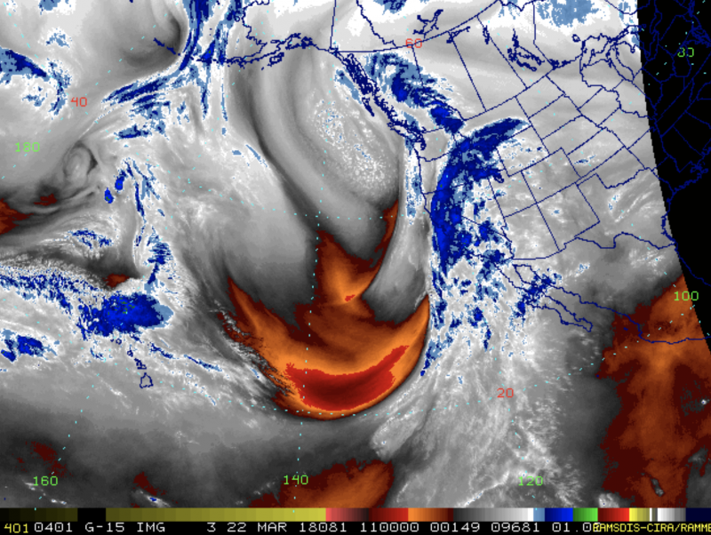
| Advisory: Salt Lake Area Mountains | Issued by Drew Hardesty for Thursday - March 22, 2018 - 4:54am |
|---|

|
bottom line We start out at MODERATE this morning and should be at CONSIDERABLE by late afternoon. Plan for it to go to HIGH danger overnight. Keep an eye on the weather - strong winds, heavy rain and snowfall - all of these lead to a rising avalanche danger on all aspects and elevations. Natural and human triggered avalanches will go from possible to certain within 24 hours. Good luck.
|
 |
special announcement On Thursday, March 8th, two skiers were caught in an avalanche on Kessler Peak in Big Cottonwood Canyon. They were extremely lucky and were not injured or buried. An interesting component to this avalanche was how they got there in the first place. Read about it here.
There is something of a cultural change happening in our community and it's an amazing and radical transformation toward openness and reflection in regards to avalanche involvements and close calls. At our avalanche discussion at the RockSteady studio Monday night, we had 65 in attendance. At least three people involved in avalanches this winter were there to discuss their experiences. This wouldn't have happened 10-15 years ago. I've written about Shame before. Tom Diegel wrote another great piece here. |
 |
current conditions It used to be called the Pineapple Express. As of 4am, temperatures are 30°F along the ridgelines and 40°F at the trailheads and base areas. Winds are southwesterly, blowing 20-25mph with gusts to 50. Light rain is already falling in the Wasatch Range and by the time it's all said and done tomorrow morning, some areas may have upwards of 1.5-maybe 2" of rain in the rain gauges. This may translate to a foot of snow at the highest elevations if we're lucky. This is all good and well, but...Certainty is the Enemy of Wisdom...and there is a great deal of uncertainty with this event. (Current water vapor loop below).
|
| type | aspect/elevation | characteristics |
|---|

|

|
LIKELIHOOD
 LIKELY
UNLIKELY
SIZE
 LARGE
SMALL
TREND
 INCREASING DANGER
SAME
DECREASING DANGER
|
|
description
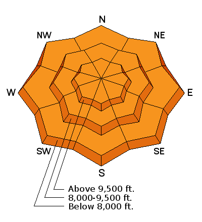
Wind drifts will be increasing in size and distribution over the course of the day. To be sure, wind damage will be general, but wind drifts will be found well off the ridgelines and in unusual areas. They will be more pronounced on northerly aspects but certainly cross-loaded onto slopes with an easterly and westerly component. They may even be terrain channelled back onto the southerly slopes, particularly at the mid-elevations. Look for and avoid the thick and rounded drifts to the lee of terrain features at the mid and upper elevations today. |
| type | aspect/elevation | characteristics |
|---|

|
|
LIKELIHOOD
 LIKELY
UNLIKELY
SIZE
LARGE
SMALL
TREND
INCREASING DANGER
SAME
DECREASING DANGER
|
|
description
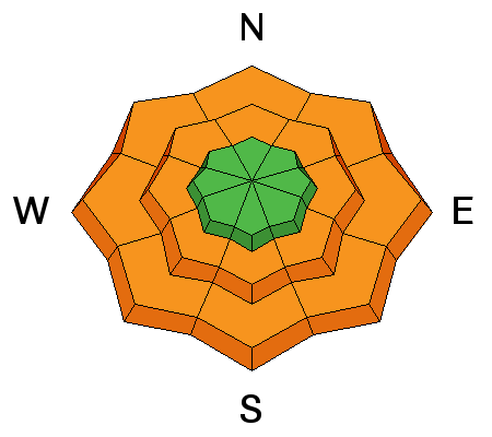
Forecast rain and then heavy rain up to 9-9500' will result in wet avalanches (sluffs and perhaps slabs) around the compass below the rain/snow line. The more significant wet activity may be expected on the northern end of the compass at the low to mid elevations where the colder, drier snow exists. Natural and human triggered wet avalanches are certain. Expect waterfalls in the mid to low elevation runouts and couloirs. Avoid being in and under steeper soggy terrain, especially in terrain traps such as creekbeds and steep-walled gullies. |
| type | aspect/elevation | characteristics |
|---|

|
|
LIKELIHOOD
LIKELY
UNLIKELY
SIZE
 LARGE
SMALL
TREND
INCREASING DANGER
SAME
DECREASING DANGER
|
|
description
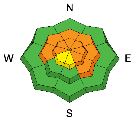
One to two inches of rain and snow-water-equivalent along with strong winds should be enough to tip the scales for deep slab activity with avalanches stepping down 3-5'+ deep and a few hundred feet wide. Again, the most problematic areas will be outside of the periphery of the upper Cottonwoods and in steep thinner rocky terrain. The smart move would be to let the storm wind down and let the snowpack adjust for a few days. Or more. |
 |
weather A significant weather event is on the doorstep. For today, expect off and on rain showers up to perhaps 9500' along with strong to very strong south to southwesterly winds. Gusts may reach 70, 80, 90 mph. Mountain temperatures will rise to the mid-30s along the highest ridgelines and in the ballpark of 50°F at the mid-elevations. This is mostly a southwest-flow event where favored areas include Provo canyon, upper American Fork, the upper Cottonwoods and the south end of the PC ridgeline. My money is on Ben Lomond up in the Ogden area mountains. Cooler air arrives in the very early hours tomorrow, bringing snow levels down to 6500'. 1-2" of rain, white rain, and snow-water-equivalent is expected. Ever heard of Sierra or Cascade cement? |
| general announcements CLICK HERE FOR MORE GENERAL INFO AND FAQ The UAC has new support programs with Outdoor Research and Darn Tough. Support the UAC through your daily shopping. When you shop at Smith's, or online at Outdoor Research, REI, Backcountry.com, Darn Tough, Patagonia, NRS, Amazon, eBay a portion of your purchase will be donated to the FUAC. See our Donate Page for more details on how you can support the UAC when you shop. Benefit the Utah Avalanche Center when you buy or sell on eBay - set the Utah Avalanche Center as a favorite non-profit in your eBay account here and click on eBay gives when you buy or sell. You can choose to have your seller fees donated to the UAC, which doesn't cost you a penny This information does not apply to developed ski areas or highways where avalanche control is normally done. This advisory is from the U.S.D.A. Forest Service, which is solely responsible for its content. This advisory describes general avalanche conditions and local variations always occur. |