25th Annual Black Diamond Fall Fundraising Party
Thursday, September 13; 6:00-10:00 PM; Black Diamond Parking Lot
25th Annual Black Diamond Fall Fundraising Party
Thursday, September 13; 6:00-10:00 PM; Black Diamond Parking Lot
| Advisory: Salt Lake Area Mountains | Issued by Evelyn Lees for Tuesday - March 20, 2018 - 6:27am |
|---|


|
bottom line The avalanche danger is MODERATE on steep slopes facing north through easterly at the mid and upper elevations. Large avalanches 2 to 5 feet deep can be triggered in isolated areas, and slopes with a shallower snowpack are the most suspect. Use normal caution as you travel through the mountains - as the snow heats today, wet loose sluffs can be triggered on steep sunny slopes and the low and mid elevation northerly facing slopes, and the danger may rise to MODERATE if the sun remains out of extended periods of time. Dry loose sluffs can be triggered on upper elevation northerly. As always, avoid travel on and below cornices.
|
 |
special announcement
We have lift tickets for Snowbasin, Snowbird, Solitude, and Powder Mountain remaining. The tickets are discounted an additional 20%. Details and order information here. All proceeds from these go towards paying for avalanche forecasting and education! The UAC Marketplace is still open. Our online marketplace still has deals on skis, packs, airbag packs, beacons, snowshoes, soft goods and much more. |
 |
current conditions It’s the Spring Equinox, with the day and night the same length. Skies are partly cloudy this morning and temperatures dropped into the teens at most mountains stations, with a few 20s on the Park City side. Winds have shifted to the southwest and are light – averaging 5 to 10 mph at the mid elevations and 15 to 20 mph on the highest peaks. Yesterday’s sun made quick work of the dry snow, and most slopes will be crusted this morning, softening later today. Upper elevation northerly facing slopes hold the last of the cold dry, powder. |
 |
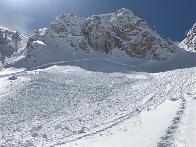
recent activity Both dry and wet loose sluffs occurred yesterday. One slide broke into old snow near the dirt layer with avalanche mitigation work - on a NE facing slope at 10,200’. In addition, an intentional cornice drop pulled out a storm snow slab 200’ wide, 1 to 2 1/2 feet deep on a lower apron below cliffs. Photo below.
|
| type | aspect/elevation | characteristics |
|---|

|
|
LIKELIHOOD
 LIKELY
UNLIKELY
SIZE
 LARGE
SMALL
TREND
 INCREASING DANGER
SAME
DECREASING DANGER
|
|
description
In isolated places, it is still possible to trigger a deep avalanche breaking on a weak facet layer in the snowpack. The most likely slope would be one with a shallower snow pack – such as a slope that has slid one or more times this year, areas outside the central Cottonwoods like along the Millcreek ridgeline, or in steep, complex rocky terrain with sharp break overs. Low probability of triggering a slide, but high consequences if you do. |
| type | aspect/elevation | characteristics |
|---|

|

|
LIKELIHOOD
LIKELY
UNLIKELY
SIZE
 LARGE
SMALL
TREND
INCREASING DANGER
SAME
DECREASING DANGER
|
|
description
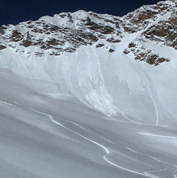
With today’s mix of mid to high level clouds, periods of sun and light winds, the snow on some slopes will heat up enough for wet loose sluffs, while other slopes will stay cool. Constantly evaluate the surface snow where you travel – if the snow becomes wet and sloppy or you’re easily triggering roller balls – it’s time to move to a cooler aspect or low angle terrain. Periods of high thin clouds can heat the snow on the shady slopes (commonly called green housing). Once wet sluffs get moving, they can entrain snow as they move down slope, piling snow up deeper than expected, especially in terrain traps like gullies and creek beds. Dry loose sluffs can be triggered on the steepest, upper elevation northerly facing slopes. Below: snow off a heating cliff band triggered wet loose sluffs. An uptrack that was safe in the cold early morning isn't once the day heats up. Mark White photo, Cardiac Ridge.
|
 |
weather We’ll have warm temperatures for the first day of spring – reaching near 30 at 10,000’ and near 40 below 9000’. Skies will be partly cloudy, and the southwesterly winds should remain light all day, 5 to 15 mph at the mid elevations, with the high peaks averaging around 20 mph. While the timing of the next storm has slowed, models are still anticipating a warm rain event, now starting on Thursday, with the heaviest rain/snow on Friday. The rain/snow line could be as high as 9,000’. Much colder air arrives Saturday, with periods of light snow for the weekend, and the snow line eventually dropping near the valley floors. |
| general announcements CLICK HERE FOR MORE GENERAL INFO AND FAQ The UAC has new support programs with Outdoor Research and Darn Tough. Support the UAC through your daily shopping. When you shop at Smith's, or online at Outdoor Research, REI, Backcountry.com, Darn Tough, Patagonia, NRS, Amazon, eBay a portion of your purchase will be donated to the FUAC. See our Donate Page for more details on how you can support the UAC when you shop. Benefit the Utah Avalanche Center when you buy or sell on eBay - set the Utah Avalanche Center as a favorite non-profit in your eBay account here and click on eBay gives when you buy or sell. You can choose to have your seller fees donated to the UAC, which doesn't cost you a penny This information does not apply to developed ski areas or highways where avalanche control is normally done. This advisory is from the U.S.D.A. Forest Service, which is solely responsible for its content. This advisory describes general avalanche conditions and local variations always occur. |