25th Annual Black Diamond Fall Fundraising Party
Thursday, September 13; 6:00-10:00 PM; Black Diamond Parking Lot
25th Annual Black Diamond Fall Fundraising Party
Thursday, September 13; 6:00-10:00 PM; Black Diamond Parking Lot
| Advisory: Salt Lake Area Mountains | Issued by Trent Meisenheimer for Sunday - March 18, 2018 - 3:55am |
|---|

|
bottom line Today the avalanche danger is CONSIDERABLE. Layers of weak faceted snow is lurking in the snowpack 2-5' feet deep and can produce large avalanches. Also, with new snow and strong winds, many fresh wind slabs and storm slabs will be found. These slabs may be 1-2' feet deep and up to 100' wide. Safer conditions exist on southerly facing slopes without wind drifted snow or on terrain that is under 30° in steepness.
|
 |
special announcement Alta will be closing Grizzly Gulch this morning until control work on Patsey Marley is finished. Please let these avalanche workers do their job by respecting this closure. They will open this terrain back up as soon as they are finished. UDOT will be doing control work on the south facing side of the canyon, terrain from Grizzly Gulch down to Lisa Falls is all closed until they finish their work. They estimate being finished by 8:00 am. |
 |
current conditions Under a cold northwest flow we have increasing clouds and mountain temperatures remain in the low teens at upper elevations. Winds are from the northwest with speeds of 5-10 mph gusting into the teens. In the past 24 hrs we've picked up another 6-12" of new dense snow. Bringing total snow since this past Wednesday close to 30" in the upper Cottonwoods. Today will be all time riding conditions with blower powder on all aspects. Probably the best day of the season in my book. However, it also has avalanche accident written all over it. Total water amounts since Wednesday morning:
|
 |
recent activity Yesterday there were two notable avalanches that broke into old snow. The first was a natural avalanche off Mt. Baldy in upper Little Cottonwood Canyon - it was 4-6' deep 100' wide running 900' down slope. The other was in upper Day's Fork when a backcountry tourer triggered a cornice on approach that then triggered an old snow avalanche that was 3.5' deep 80' wide and running down into the flats. (picture below) Numerous storm slabs were triggered yesterday - many of these were 12'' deep and up to 100' wide, failing within the storm snow. Backcountry riders also reported that the snow was cracky and slabby, especially in the wind zone. Dry loose avalanche were also noted in terrain > 30°. Photo: Bill Nalli - Deep slab in upper Day's Fork.
|
| type | aspect/elevation | characteristics |
|---|

|

|
LIKELIHOOD
 LIKELY
UNLIKELY
SIZE
 LARGE
SMALL
TREND
 INCREASING DANGER
SAME
DECREASING DANGER
|
|
description
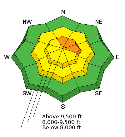
Storm Slab: Heavy snow fall has created instabilities within the storm snow. This issue will be on all aspects and elevations above about 8,000'. I would expect storm slab avalanches failing within the new snow to be touchy this morning, especially in steep terrain. These will be 12-18" deep and up to 100' wide and large enough to bury a person. The good news, is this problem should begin to settle out this afternoon. Wind Slab: Strong winds over the past few days have drifted snow onto many aspects and elevations. The most suspect terrain will be north through south-east facing slopes at upper elevations. To add insult to injury - it will be hard to identify this problem, because they are now covered by yesterday's 6-12" of new snow. Always avoid rounded pillowy snow or fresh drifts of wind blown snow. Loose Dry: Any slope steeper than 30° will produce long running sluffs within the top few inches of low density snow. Be sure to manage your terrain by heading from safe point to safe point and don't ride above your partner. Cornices: Have grown large and sensitive in the past few days. Yesterday during my field day I was able to remotely trigger a cornice just by walking close to it. Give these a wide berth as they tend to break further back than expected. If you're walking ridges today make sure no one is below you before approaching cornices. |
| type | aspect/elevation | characteristics |
|---|

|
|
LIKELIHOOD
LIKELY
UNLIKELY
SIZE
 LARGE
SMALL
TREND
 INCREASING DANGER
SAME
DECREASING DANGER
|
|
description
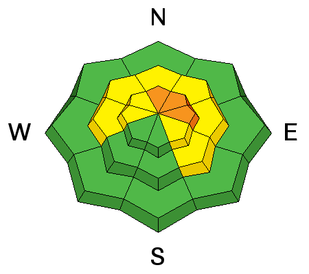
With upwards of 3" inches of water weight falling through-out the range you can expect these deeper weak layers to be coming back to life. The evidence is two old snow avalanches triggered yesterday, both failing at the ground and large enough to kill a person. Deep Slabs are not to be taken lightly, these are killers. They will be most pronounced at upper elevations facing the north half of the compass. They are easy to avoid - watch your slope angles, making sure nothing is steep above or adjacent to you. Choose conservative terrain and give your self outs if something does happen. Here’s what we know about this avalanche problem:
Quick thought on water weight: Picture a football field covered in 3" of liquid water. If you do the math you'll see it comes out to roughly 900,000 lbs that's 444 tons or simply put -the weight of ten Boeing 737 air planes. Now the scary thought is to think about tilting all that weight up to 38° degrees. How would you feel walking underneath or riding when that much weight comes crashing down?
|
 |
weather We will continue to be under a northwest flow for much of the day. You can expect increasing clouds and spotty snow showers this afternoon. Winds will be from the north and may increase as the day goes on. Speeds should be in the 10-15 mph range with the occasional gust into the 20's at upper elevations. Temperatures will remain cold only topping out into the mid 20's this afternoon. Brief high pressure for the start of the week before we turn wet and windy again by mid week. I love it when the National Weather Service forecaster tells you there is a moisture tap coming out of the tropics by mid week. |
| general announcements CLICK HERE FOR MORE GENERAL INFO AND FAQ The UAC has new support programs with Outdoor Research and Darn Tough. Support the UAC through your daily shopping. When you shop at Smith's, or online at Outdoor Research, REI, Backcountry.com, Darn Tough, Patagonia, NRS, Amazon, eBay a portion of your purchase will be donated to the FUAC. See our Donate Page for more details on how you can support the UAC when you shop. Benefit the Utah Avalanche Center when you buy or sell on eBay - set the Utah Avalanche Center as a favorite non-profit in your eBay account here and click on eBay gives when you buy or sell. You can choose to have your seller fees donated to the UAC, which doesn't cost you a penny This information does not apply to developed ski areas or highways where avalanche control is normally done. This advisory is from the U.S.D.A. Forest Service, which is solely responsible for its content. This advisory describes general avalanche conditions and local variations always occur. |