25th Annual Black Diamond Fall Fundraising Party
Thursday, September 13; 6:00-10:00 PM; Black Diamond Parking Lot
25th Annual Black Diamond Fall Fundraising Party
Thursday, September 13; 6:00-10:00 PM; Black Diamond Parking Lot
| Advisory: Salt Lake Area Mountains | Issued by Evelyn Lees for Sunday - March 11, 2018 - 6:14am |
|---|

|
bottom line The avalanche danger is MODERATE - large avalanches 2 to 5 feet deep can be triggered in isolated areas - avoid steep slopes facing northwest through southeasterly at the mid and upper elevations. Warm temperatures and periods of sun will heat the snow, and wet loose avalanches can be triggered on all aspects on mid and low elevation slopes and on steep, sunny slopes later today. Safer riding conditions can be on lower-angle terrain with no steep slopes above. Roof-avalanches are occurring as snow slides off building roofs, with debris piles deep enough to bury and kill a person.
|
 |
special announcement Alta Ski Area will close Grizzly Gulch on Monday March 12th for helicopter rescue training. Grizzly Gulch is private property. Please respect this closure. Alta may close access to Grizzly Gulch during upcoming storm events until avalanche mitigation on Patsey Marley is complete.
|
 |
current conditions Under mostly clear skies, there was a good refreeze overnight – temperatures are in the 20s at most elevations. Winds are from southeast, 10 to 15 mph averages, with the high peaks averaging 20 mph. A bit of soft dense remains on northerly facing slopes above about 9,000’, all other slopes are sporting frozen crusts this morning, many breakable, that should soften with daytime heating. |
 |
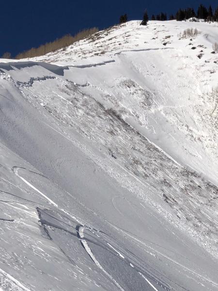
recent activity Another deep, dangerous slab avalanche was triggered yesterday – with a good outcome as no one was caught. Many, many thanks to those involved for quickly reporting the avalanche to the Utah Avalanche Center by phone - 801-524-5304. 1. It allowed us to provide other backcountry users with real time information via text and IG, which may save lives. 2. It can prevent an unnecessary search should someone notice the debris and think someone might be buried. First Cornice is on the Midway side of Guardsman Pass. Preliminary information is here. March 10th First Cornice avalanche, Photos by Colby Zimmerman
|
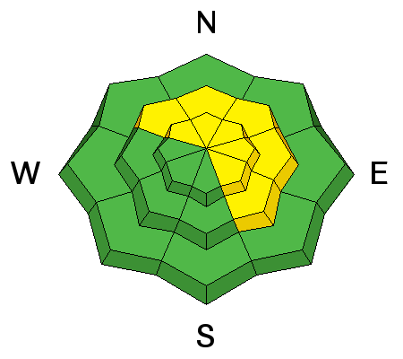
| type | aspect/elevation | characteristics |
|---|

|
|
LIKELIHOOD
 LIKELY
UNLIKELY
SIZE
 LARGE
SMALL
TREND
 INCREASING DANGER
SAME
DECREASING DANGER
|
|
description
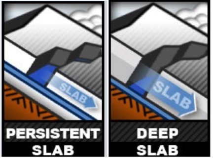
In parts of the Salt Lake and Park City area mountains, we are transitioning from Persistent Slab to a Deep Slab avalanche problem. Deep slab avalanches are hard slabs, typically difficult to trigger and very destructive and dangerous due to the large mass of snow involved. They are particularly difficult to forecast and manage.
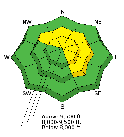
The weak layers involved are the same – a faceted layer that formed in early February (a few inches below a dirt layer on some slopes) and/or the November facets on the ground – depth hoar. But the slides are larger. Some of the steep slopes are just waiting for a trigger – and which slopes will slide are variable and unpredictable, but steep mid and upper elevations slopes facing northwest thorough southeasterly are the bulls eye terrain. Especially avoid steep, complex terrain with break overs, shallow rocky spots with a thin snowpack and cliffs and be aware of changes in aspect. |
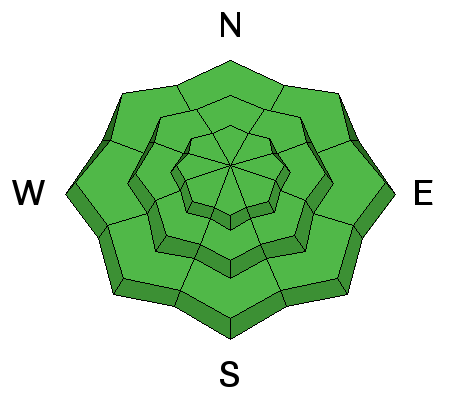
| type | aspect/elevation | characteristics |
|---|

|
|
LIKELIHOOD
LIKELY
UNLIKELY
SIZE
 LARGE
SMALL
TREND
 INCREASING DANGER
SAME
DECREASING DANGER
|
|
description
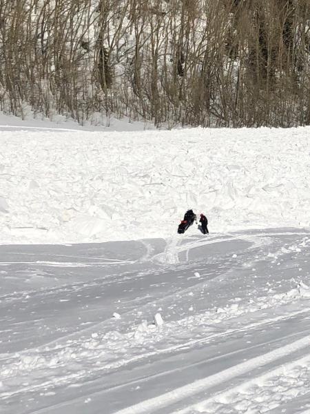
Wet Loose: As the temperatures warm into the 30s and 40s today, the snow will once again become wet and sloppy on most aspects and elevations. The increasing clouds should help prevent natural wet snow slides, but rider triggered wet loose sluffs will be possible on all aspects and elevations except the high northerly facing slopes. Roof-avalanches: Buildings are starting to shed their winter snow, so look up and avoid travel below steep roofs. Dave Richards photo:
Cornices have softened and are sensitive, often breaking back further than expected, on to what looks like flat terrain. So give them a wide berth and avoid travel below them. |
 |
weather A small storm system crossing southern Utah today is sending clouds our way. Skies should become mostly cloudy today and the southeasterly winds remain light, with speeds in the 5 to 15 mph range. Today’s high temperatures will be in the mid 30 to low 40s. The warming trend will continue into Wednesday, with a chance for mountain snow and cooler temperatures late in the week. |
| general announcements CLICK HERE FOR MORE GENERAL INFO AND FAQ The UAC has new support programs with Outdoor Research and Darn Tough. Support the UAC through your daily shopping. When you shop at Smith's, or online at Outdoor Research, REI, Backcountry.com, Darn Tough, Patagonia, NRS, Amazon, eBay a portion of your purchase will be donated to the FUAC. See our Donate Page for more details on how you can support the UAC when you shop. Benefit the Utah Avalanche Center when you buy or sell on eBay - set the Utah Avalanche Center as a favorite non-profit in your eBay account here and click on eBay gives when you buy or sell. You can choose to have your seller fees donated to the UAC, which doesn't cost you a penny This information does not apply to developed ski areas or highways where avalanche control is normally done. This advisory is from the U.S.D.A. Forest Service, which is solely responsible for its content. This advisory describes general avalanche conditions and local variations always occur. |


 We Need Your Help With Social Media