25th Annual Black Diamond Fall Fundraising Party
Thursday, September 13; 6:00-10:00 PM; Black Diamond Parking Lot
25th Annual Black Diamond Fall Fundraising Party
Thursday, September 13; 6:00-10:00 PM; Black Diamond Parking Lot
| Advisory: Salt Lake Area Mountains | Issued by Drew Hardesty for Thursday - March 8, 2018 - 5:36am |
|---|

|
bottom line Today's MODERATE DANGER is two-fold:
ROOF-ALANCHES are likely and have resulted in fatalities in years past. SAFE and EXCELLENT riding conditions can be found on low angle northerly terrain with no overhead hazard.
|
 |
special announcement We have discount lift tickets for Alta, Snowbird, Brighton, Solitude, Snowbasin,and Beaver Mountain. Details and order information here. All proceeds from these go towards paying for avalanche forecasting and education! Today and Saturday (March 8th & 10th) Be prepared if going snowshoeing - Snowshoe Backcountry 101 Introduction to Avalanches at Brighton Resort. Two snowshoers were killed in an avalanche in Washington just over a week ago. Get educated or recommend this class to a friend.
|
 |
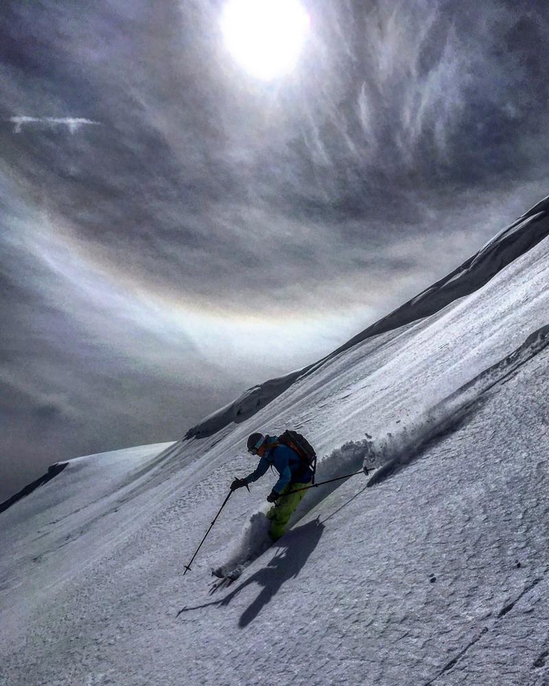
current conditions Skies are clear, ain't it a shame. Mountain temperatures are in the low to mid-20s; winds are west to southwesterly, blowing 10mph with gusts to 15. Skiing and riding conditions remain excellent in the weakening and recrystallizing snow on the sheltered, northerly slopes. All other aspects are well sun damaged and will have a breakable melt-freeze crust this morning. I received the photo below from observer Mark White yesterday. He was asking in jest if the sundog meant it was going to snow. Sometimes it does as the sundog hints at moisture - generally upper level cirrus ice crystals, actually - in the atmosphere...but the short answer is No. Unless Friday night's trace to an inch counts.
|
 |
recent activity Yesterday's significant activity: White Pine Chutes 1 & 2 in mid-Little Cottonwood shed part or all of their weekend storm snow yesterday just before 2pm. Too much sun, too much heat. Bountiful/Sessions Mountains - explosive testing produced two large (size 3) avalanches on steep northeast facing slopes at roughly 9000', running fast and far and leaving significant debris piles. Provo Mountains - The NE Chute of Elk Point likely naturalled yesterday (possibly on Tuesday). Elk Point is a sub-peak of Timpanogos, looming large above Aspen Grove (up the street from Sundance). It likely ran over 3000' and left a sizeable debris pile (pc: Warnick). Elk Point has some of the more interesting avalanche paths on Timpanogos and the NE Chute was the site of the tragic triple fatality the day after Christmas 2003. (Disregard the slope and aspect on the app below. The starting zone was probably 10,600' on a very steep east to northeast face.)
|
| type | aspect/elevation | characteristics |
|---|

|
|
LIKELIHOOD
 LIKELY
UNLIKELY
SIZE
 LARGE
SMALL
TREND
 INCREASING DANGER
SAME
DECREASING DANGER
|
|
description
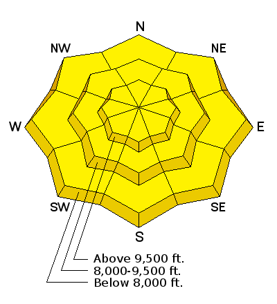
Persistent slab and deep slab avalanches tend to come roaring back to life during and just after significant loading events....and then become increasingly pockety and stubborn over the following days. They may still be triggered today by a heavy loading event or significant trigger (cornice drop, "catching air with a hard landing", other new snow avalanche from above) and may still be triggered by human weight, particularly along the periphery of the upper Cottonwoods. Best to avoid thinner, rocky terrain that has seen significant wind loading on the steep west to north to southeast facing slopes above about 9000'. Remember terrain is your friend: enjoy the powder on low angle slopes with no overhead hazard. List of (likely) persistent slab avalanches from the last three days - 03/7/2018 Provo region: Avalanche: Elk Point, Natural trigger - unknown deep - Unknown' wide 03/7/2018 Uintas region: Avalanche: Humpy Peak, Snowmobiler trigger - 6' deep - 50' wide 03/6/2018 Salt Lake region: Accident: Major Evans Gulch, Snowmobiler trigger - 3' deep - 500' wide 03/6/2018 Salt Lake region: Avalanche: Mt Olympus, Snowboarder trigger - 3' deep - 15' wide 03/6/2018 Salt Lake region: Avalanche: Mill Canyon, Skier trigger - 2.5' deep - 200' wide 03/5/2018 Salt Lake region: Avalanche: Mary Ellen, Snowmobiler trigger - 3' deep - 45' wide |
| type | aspect/elevation | characteristics |
|---|

|
|
LIKELIHOOD
 LIKELY
UNLIKELY
SIZE
 LARGE
SMALL
TREND
 INCREASING DANGER
SAME
DECREASING DANGER
|
|
description
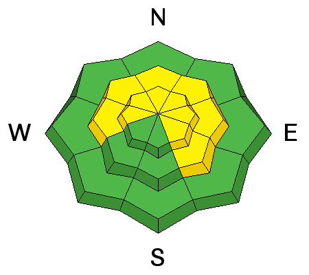
Warmer overnight temperatures, early direct sun, and temps warming to the 40s at the mid-elevations, and perhaps some later afternoon greenhousing will certainly activate the wet avalache activity. Natural and human triggered wet avalanches will be likely and may subsequently trigger still-stabilizing storm slabs on the way downslope. I expect there may be decent debris piles beneath the steepest, most sustained avalanche slopes. Don't overstay your welcome - the window will be quite narrow between breakable crust and wet/unstable. Choose the cold snow instead. KEY POINT: ROOF-A-LANCHES will be a significant concern. Watch for many houses to shed their winter coats with the sun and daytime heating. Fatalities have occurred due to this very real hazard. |
 |
weather High and dry with some more cloud cover filtering through this afternoon. Expect ridgetop highs to be in the mid-30s with light west to southwest winds. I expect the winds to pick up this afternoon, particularly in the Logan area mountains and along the Idaho border. A weak cold front moves through Friday night and we may see a few flakes of snow. Saturday has some clearing with high pressure building back over the state. Some clouds early week. Later in teh week looks interesting...though it may be a southern Utah special. Stay tuned. |
| general announcements CLICK HERE FOR MORE GENERAL INFO AND FAQ The UAC has new support programs with Outdoor Research and Darn Tough. Support the UAC through your daily shopping. When you shop at Smith's, or online at Outdoor Research, REI, Backcountry.com, Darn Tough, Patagonia, NRS, Amazon, eBay a portion of your purchase will be donated to the FUAC. See our Donate Page for more details on how you can support the UAC when you shop. Benefit the Utah Avalanche Center when you buy or sell on eBay - set the Utah Avalanche Center as a favorite non-profit in your eBay account here and click on eBay gives when you buy or sell. You can choose to have your seller fees donated to the UAC, which doesn't cost you a penny This information does not apply to developed ski areas or highways where avalanche control is normally done. This advisory is from the U.S.D.A. Forest Service, which is solely responsible for its content. This advisory describes general avalanche conditions and local variations always occur. |


 We Need Your Help With Social Media