25th Annual Black Diamond Fall Fundraising Party
Thursday, September 13; 6:00-10:00 PM; Black Diamond Parking Lot
25th Annual Black Diamond Fall Fundraising Party
Thursday, September 13; 6:00-10:00 PM; Black Diamond Parking Lot
| Advisory: Salt Lake Area Mountains | Issued by Trent Meisenheimer for Tuesday - February 27, 2018 - 3:47am |
|---|

|
bottom line The avalanche danger is CONSIDERABLE on all steep, upper elevation slopes facing northwest through southeast, especially those with recent wind drifts. Other steep slopes have a MODERATE danger. Complex and dangerous avalanche conditions exist – cautious route finding, careful snow pack evaluation and conservative decision making essential.
|
 |
special announcement We have discount lift tickets for Alta, Snowbird, Brighton, Solitude, Snowbasin, and Beaver Mountain. Details and order information here. All proceeds from these go towards paying for avalanche forecasting and education! |
 |
current conditions Under mostly cloudy skies this morning the southerly winds continue to blow with average speeds of 15-20 mph gusting into the 30's at 10,000'. In the past 24 hrs we have picked up a trace to two inches of new snow and mountain temperatures this morning remain in the teens °F. The southerly winds have damaged much of the soft powder snow in the alpine and down off of ridgelines. However, once out of the wind zone, excellent powder does exist on the protected aspects. Southerly facing terrain will have a thin melt freeze crust or be damaged from the wind. |
 |
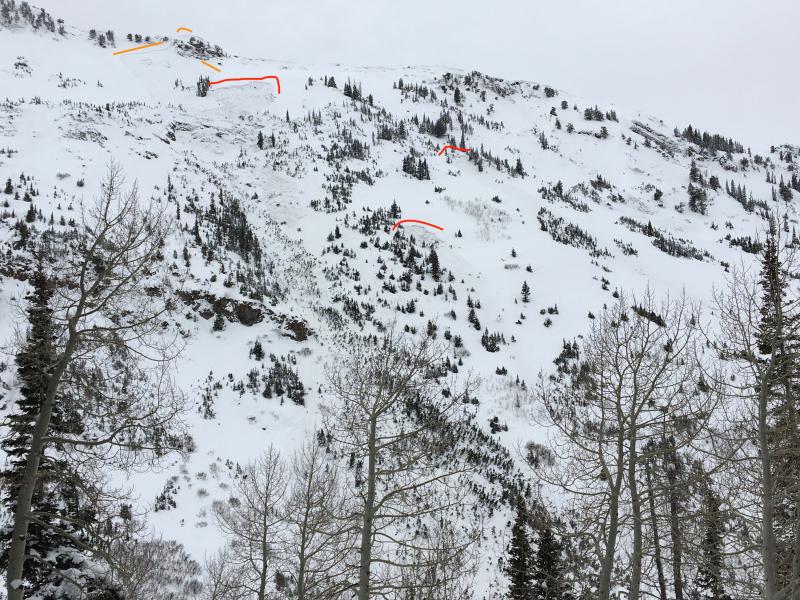
recent activity Yesterday's bump in the wind speeds were responsible for a significant natural avalanche in Mineral Fork Canyon. The avalanche was triggered from a cornice falling that then triggered a small wind slab. As the wind slab moved down slope it triggered a much deeper, and more dangerous slab avalanche. The main avalanche was roughly 4-5' deep and up to 100' wide, failing in old weak snow near the ground. The main avalanche then sympathetically triggered (from a distance) two more slides adjacent to it. The main avalanche was large enough to break trees and left a big enough debris pile to bury a person. Photo: Stetson - Feb 26th, natural avalanche Mineral Fork. Orange line shows the initial cornice / wind slab. Red lines show the sympathetic slides.
|
| type | aspect/elevation | characteristics |
|---|

|
|
LIKELIHOOD
 LIKELY
UNLIKELY
SIZE
 LARGE
SMALL
TREND
 INCREASING DANGER
SAME
DECREASING DANGER
|
|
description
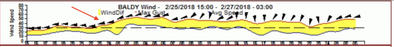
Southerly winds have created soft and hard slabs along ridgelines and terrain features. Today the south winds will keep these drifts fresh and sensitive to the weight of a rider. You can expect the drifts to be 1-2' deep and most pronounced on northwest through southeast facing terrain. There is also potential that if you trigger a wind slab it could then step down into deeper weaker layers in the snowpack. (see recent activity for description) Photo: hourly data from Mt. Baldy in upper Little Cottonwood Canyon, it's easy to see the spike in wind speeds starting yesterday morning.
Cornices have continued to grow along the mid and upper elevation ridge lines. They often break back further than expected, so give them a wide berth and avoid travel below them. |
| type | aspect/elevation | characteristics |
|---|

|
|
LIKELIHOOD
 LIKELY
UNLIKELY
SIZE
 LARGE
SMALL
TREND
INCREASING DANGER
SAME
DECREASING DANGER
|
|
description
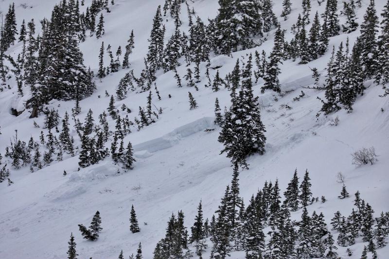
Yesterday's winds were all it took to tip the scale in Mineral Fork. It shows that there are slopes hanging in balance waiting for a trigger. The chance of triggering a persistent slab is increasing with each loading (wind or snow) event we receive. This problem is most pronounced in shallow snowpack areas where the snowpack is less than 2-4' deep or where the slope has already avalanched this year (called a repeater slide). Avoid, steep, shallow, rocky, wind loaded terrain, where the snowpack is thinner and more suspect. If you trigger a persistent slab avalanche it will likely be unsurvivable. Photo: Peter Vintoniv - Feb 26th Mineral Fork. This photo is one of three avalanches, all failing in faceted (weak) snow near the ground.
|
 |
weather Southerly winds and clouds will continue for much of the day. There is a chance the sun will pop out here and there followed by a scattered snow shower. Wind speeds should be confined to 15-25 mph across the high terrain. Temperatures warm up into the mid to upper twenties °F before cooling off this evening. The good news - we have a very organized storm that will deliver snow and water for the weekend. South winds ramp up Thursday ahead of the cold front that sweeps down out of the arctic and lands on our doorstep Friday morning lasting through the weekend. |
| general announcements CLICK HERE FOR MORE GENERAL INFO AND FAQ The UAC has new support programs with Outdoor Research and Darn Tough. Support the UAC through your daily shopping. When you shop at Smith's, or online at Outdoor Research, REI, Backcountry.com, Darn Tough, Patagonia, NRS, Amazon, eBay a portion of your purchase will be donated to the FUAC. See our Donate Page for more details on how you can support the UAC when you shop. Benefit the Utah Avalanche Center when you buy or sell on eBay - set the Utah Avalanche Center as a favorite non-profit in your eBay account here and click on eBay gives when you buy or sell. You can choose to have your seller fees donated to the UAC, which doesn't cost you a penny This information does not apply to developed ski areas or highways where avalanche control is normally done. This advisory is from the U.S.D.A. Forest Service, which is solely responsible for its content. This advisory describes general avalanche conditions and local variations always occur. |