25th Annual Black Diamond Fall Fundraising Party
Thursday, September 13; 6:00-10:00 PM; Black Diamond Parking Lot
25th Annual Black Diamond Fall Fundraising Party
Thursday, September 13; 6:00-10:00 PM; Black Diamond Parking Lot
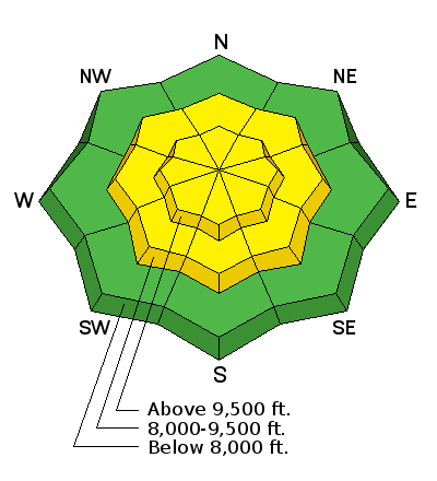
| Advisory: Salt Lake Area Mountains | Issued by Drew Hardesty for Thursday - February 15, 2018 - 5:36am |
|---|

|
bottom line A MODERATE danger exists for new snow instabilties - wind drifts and sluffing - at the mid and upper elevations. Avalanches stepping into old snow 1-3' deep continue to warrant an isolated MODERATE danger, primarily on north to northeast facing slopes above 9000'. The Fine Print: If we see more snow than expected or experience periods of particularly high snowfall rates, the danger will rise accordingly.
|
 |
special announcement Tonight! At the Iron Blosam Lodge at Snowbird. Jenna Malone is a powerhouse avalanche educator, heli-ski guide, ski patroller, and neurosurgery and trauma PA. She's great, come check out her talk at 6pm tonight.
At 6PM on February 17 at Alpine Distilling in Park City, join a presentation on the UAC's Avalanche Awareness Know Before You Go Program then learn about how we perceive aroma and taste through whiskey while seeing how Alpine Distilling crafts local, award winning spirits. The evening will feature a specialty cocktail made with Alpine Distilling's Persistent (Weak Layer) Vodka and include a raffle for a backcountry kit (beacon, shovel, and probe) donated by Backcountry.com. Contact [email protected] for details and reservations. The Whole Foods Bag Donation to support the UAC has been extended to March 31. When you bring your own bags to Whole Foods in Sugar House, Trolley Square, and Cottonwood Heights you can choose to have the UAC be the recipient of your 10 cent bag credit. |
 |
current conditions Yes, Evelyn had it right at the start yesterday. Yesterday indeed was not the day before. But today might be. Storm totals overnight are 6-8" (0.45"SWE) in the Cottonwoods and along the north end of the Park City ridgeline. Even the 9000' snotel site in Mill D North of BCC is reporting 8". The winds veered to the west and northwest overnight and are blowing 15mph with gusts to 30. I am glad to have yesterday's strong southerlies in the rearview mirror, so to speak. Mountain temperatures are in the teens and headed toward the single digits. Riding conditions should be much improved. (Yesterday's weather below) |
 |
recent activity None reported in the central Wasatch, though some touchy wind slabs noted in the Western Uintas. |
| type | aspect/elevation | characteristics |
|---|

|
|
LIKELIHOOD
 LIKELY
UNLIKELY
SIZE
 LARGE
SMALL
TREND
 INCREASING DANGER
SAME
DECREASING DANGER
|
|
description
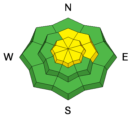
Old and new wind drifts. Yesterday's winds transported Ev's beautiful bluebird powder snow that I missed on Tuesday into oblivion with drifts pockety and scattered well off the ridgelines and channeled into unusual locations. I spoke to a party who skied the steeps into Wolverine Cirque and found the wind drifts well into the aprons. These drifts will have settled somewhat overnight, but shouldn't be forgotten, although they'll be out of sight, buried beneath the new snow. Along the highest elevations, the winds are just at the threshold to move the 6% density snow into shallow drifts just to the lee of ridgelines. They'll be more prominent on northeast to east to south facing slopes. |
| type | aspect/elevation | characteristics |
|---|

|
|
LIKELIHOOD
 LIKELY
UNLIKELY
SIZE
LARGE
SMALL
TREND
 INCREASING DANGER
SAME
DECREASING DANGER
|
|
description
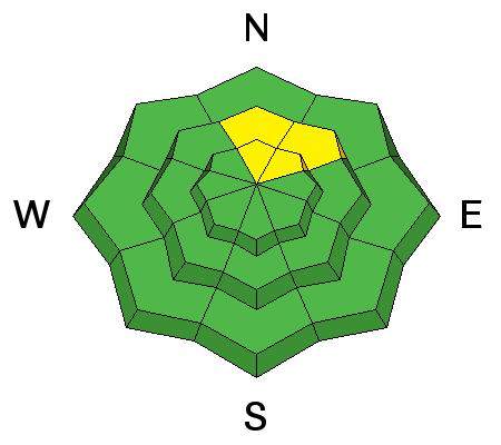
We continue to incrementally load our buried faceted weak layers with a series of small storms and wind events. I have backed off or walked passed two intended objectives in the past week alone. Steep, rocky, thinner snowpack areas with well developed depth hoar (weak large grain grey crystals at the base of the snowpack) are most suspect. Large cornice falls, Olympic size freestyle aerials, or another, more superficial avalanche are potential ways to trigger one of these deeper avalanches. There is a lot of variability in the snowpack strength and depth. Slopes with a shallower snowpack, especially those that are rocky, tend to have weaker snow. Spatial variabitlity is what we call the differences from one slope to another and could make for tricky conditions if we get the forecast snow and wind. See a short discussion in this video. |
| type | aspect/elevation | characteristics |
|---|

|
|
LIKELIHOOD
LIKELY
UNLIKELY
SIZE
LARGE
SMALL
TREND
 INCREASING DANGER
SAME
DECREASING DANGER
|
|
description
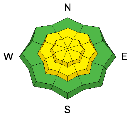
Sluffing of the new low density snow is possible on the steepest slopes of all aspects today. They may run on the slick underlyling crusts or at the interface of yesterday's pellet-like graupel snow. Point-release avalanches generally need slopes approaching 40° and steeper and may run naturally during periods of high snowfall rates. Keep your eyes open today. |
 |
weather We'll see continued snowfall this morning with 2-4" possible by late morning as even colder more unstable air moves overhead. Lightning may be possible. Winds will be 15-20mph from the west-northwest. Temps will continue to dive into the single digits along the higher elevations. A clipper moves through Friday night with another storm likely for Sunday. |
| general announcements CLICK HERE FOR MORE GENERAL INFO AND FAQ The UAC has new support programs with Outdoor Research and Darn Tough. Support the UAC through your daily shopping. When you shop at Smith's, or online at Outdoor Research, REI, Backcountry.com, Darn Tough, Patagonia, NRS, Amazon, eBay a portion of your purchase will be donated to the FUAC. See our Donate Page for more details on how you can support the UAC when you shop. Benefit the Utah Avalanche Center when you buy or sell on eBay - set the Utah Avalanche Center as a favorite non-profit in your eBay account here and click on eBay gives when you buy or sell. You can choose to have your seller fees donated to the UAC, which doesn't cost you a penny This information does not apply to developed ski areas or highways where avalanche control is normally done. This advisory is from the U.S.D.A. Forest Service, which is solely responsible for its content. This advisory describes general avalanche conditions and local variations always occur. |


