25th Annual Black Diamond Fall Fundraising Party
Thursday, September 13; 6:00-10:00 PM; Black Diamond Parking Lot
25th Annual Black Diamond Fall Fundraising Party
Thursday, September 13; 6:00-10:00 PM; Black Diamond Parking Lot
| Advisory: Salt Lake Area Mountains | Issued by Evelyn Lees for Wednesday - February 14, 2018 - 6:21am |
|---|

|
bottom line The avalanche danger is MODERATE for triggering a new wind drift on steep mid and upper elevations slopes. Deeper avalanches stepping into old snow are possible in isolated steep terrain with poor snow structure - and there is a MODERATE danger on steep, north and northeast facing slopes at the mid and upper elevations.
|
 |
special announcement At 6PM on February 17 at Alpine Distilling in Park City, join a presentation on the UAC's Avalanche Awareness Know Before You Go Program then learn about how we perceive aroma and taste through whiskey while seeing how Alpine Distilling crafts local, award winning spirits. The evening will feature a specialty cocktail made with Alpine Distilling's Persistent (Weak Layer) Vodka and include a raffle for a backcountry kit (beacon, shovel, and probe) donated by Backcountry.com. Contact [email protected] for details and reservations. The Whole Foods Bag Donation to support the UAC has been extended to March 31. When you bring your own bags to Whole Foods in Sugar House, Trolley Square, and Cottonwood Heights you can choose to have the UAC be the recipient of your 10 cent bag credit. |
 |
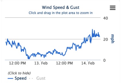
current conditions Sadly, today is not yesterday. Under increasingly cloudy skies, the southwesterly winds picked up and are averaging 25 to 35 mph, with gusts in the 40s and 50s. Temperatures are in the teens at the upper elevations, and in the twenties at the mid elevations. Snow on the sunny southeast through westerly facing slopes will be crusted, open bowls wind damaged, but excellent soft powder remains on wind-sheltered shady slopes. 48 hour wind graphs of average wind speeds (no gusts) – Cardiff (10,277’) on the left, Reynolds (9,422’) on the right
|
 |
recent activity A few dry loose sluffs were the only activity reported from the backcountry yesterday. |
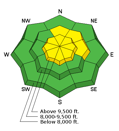
| type | aspect/elevation | characteristics |
|---|

|
|
LIKELIHOOD
 LIKELY
UNLIKELY
SIZE
 LARGE
SMALL
TREND
 INCREASING DANGER
SAME
DECREASING DANGER
|
|
description
Today’s combination of steady winds and powder snow available for transport will result in sensitive, fresh wind drifts. Wind drifts, known as wind slabs, often look smooth and rounded, and when you find one, they can be cracky, denser and deeper than the surrounding snow. As the winds are getting well down into the mid elevations, look for drifts along both mid and upper elevation ridgelines and cross-loaded along gully walls, mid slope break overs and sub ridges. Avoid any wind drifts on steep slopes. |
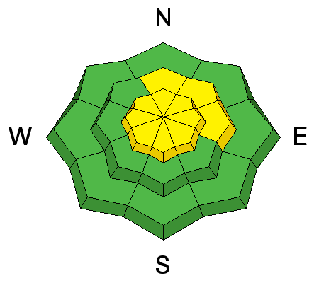
| type | aspect/elevation | characteristics |
|---|

|
|
LIKELIHOOD
LIKELY
UNLIKELY
SIZE
LARGE
SMALL
TREND
INCREASING DANGER
SAME
DECREASING DANGER
|
|
description
We are incrementally loading our buried faceted weak layers with a series of small storms and wind events. With today’s southwesterly winds drifting the snow, the buried faceted weak layers in the upper snowpack on northwesterly through easterly facing slopes may be getting just a bit tweaky. A triggered wind drift stepping down to an upper (the thin rime crust) or mid pack weak layer is most likely way to trigger a deeper slide. Any cracking or collapsing is a bulls eye clue to instability. There is a lot of variability in the snowpack strength and depth. Slopes with a shallower snowpack, especially those that are rocky, tend to have weaker snow. Spatial variabitlity is what we call the differences from one slope to another and could make for tricky conditions if we get the forecast snow and wind. See a short discussion in this video. |
 |
weather Northern Utah will be under a moderate to strong southwesterly flow today ahead of a storm. Increasing clouds today, with light snow starting late this afternoon. Winds will remain brisk – 20 to 30 mph averages at the mid and upper elevations, with gusts in the 50s along the highest peaks. Temperatures will warm into the 30s at the mid elevations, and 20s at the higher elevations. Snow tonight, with snow showers continuing into tomorrow afternoon. 4 to 8” of snow is possible by Thursday afternoon. |
| general announcements CLICK HERE FOR MORE GENERAL INFO AND FAQ The UAC has new support programs with Outdoor Research and Darn Tough. Support the UAC through your daily shopping. When you shop at Smith's, or online at Outdoor Research, REI, Backcountry.com, Darn Tough, Patagonia, NRS, Amazon, eBay a portion of your purchase will be donated to the FUAC. See our Donate Page for more details on how you can support the UAC when you shop. Benefit the Utah Avalanche Center when you buy or sell on eBay - set the Utah Avalanche Center as a favorite non-profit in your eBay account here and click on eBay gives when you buy or sell. You can choose to have your seller fees donated to the UAC, which doesn't cost you a penny This information does not apply to developed ski areas or highways where avalanche control is normally done. This advisory is from the U.S.D.A. Forest Service, which is solely responsible for its content. This advisory describes general avalanche conditions and local variations always occur. |