25th Annual Black Diamond Fall Fundraising Party
Thursday, September 13; 6:00-10:00 PM; Black Diamond Parking Lot
25th Annual Black Diamond Fall Fundraising Party
Thursday, September 13; 6:00-10:00 PM; Black Diamond Parking Lot
| Advisory: Salt Lake Area Mountains | Issued by Mark Staples for Tuesday - February 13, 2018 - 5:37am |
|---|

|
bottom line The danger today is LOW and avalanche conditions are generally safe. Watch for isolated wind slabs from Sunday's south winds. Also watch for small, wet loose avalanches on south facing slopes as the day warms.
|
 |
special announcement At 6PM on February 17 at Alpine Distilling in Park City, join a presentation on the UAC's Avalanche Awareness Know Before You Go Program then learn about how we perceive aroma and taste through whiskey while seeing how Alpine Distilling crafts local, award winning spirits. The evening will feature a specialty cocktail made with Alpine Distilling's Persistent (Weak Layer) Vodka and include a raffle for a backcountry kit (beacon, shovel, and probe) donated by Backcountry.com. Contact [email protected] for details and reservations. The Whole Foods Bag Donation to support the UAC has been extended to March 31. When you bring your own bags to Whole Foods in Sugar House, Trolley Square, and Cottonwood Heights you can choose to have the UAC be the recipient of your 10 cent bag credit. |
 |
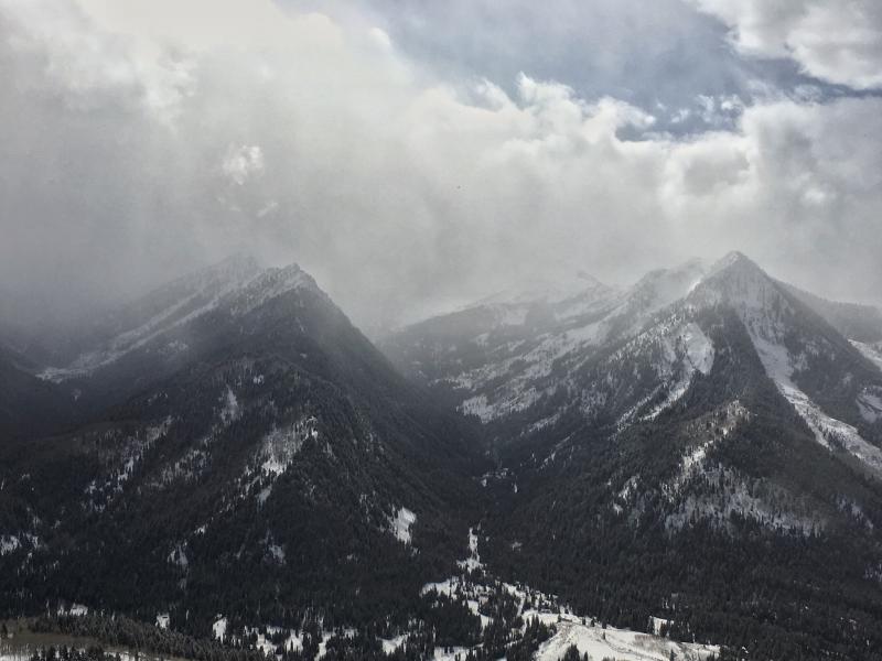
current conditions It's relatively calm and cold this morning with consistent temperature and wind speeds across all elevations. Temperatures are hovering around 15 degrees F at most places. Light winds in valleys and at ridgetops are averaging 5 mph gusting to 10 mph from the SE. This morning should be a beautiful one to be in the mountains with such light winds and cold temperatures. Yesterday's snowfall favored the upper reaches of the Cottonwood Canyons with 6-7 inches of light snow at upper elevations and 3-4 inches at mid elevations. Along the PC ridgeline and in mid-canyon locations only 1-2 inches of snow fell. The combination of yesterday's and Saturday's snow has created great riding conditions. Southerly aspects did get enough sun yesterday to warm the new snow which should have a thin crust this morning. Photo of the view from Reynolds Peak in Big Cottonwood Canyon where Evelyn and I skied yesterday.
|
 |
recent activity On Sunday there were some shallow, loose wet avalanches on southerly facing slopes especially ones with exposed rock bands. There were also some shallow, loose dry sluffs. These small slides occurred predictably and were not big enough to bury a person. Despite Sunday's strong south winds, ski areas reported minimal wind slabs and mostly sluffing of the new snow in steep terrain. |
| type | aspect/elevation | characteristics |
|---|

|

|
LIKELIHOOD
 LIKELY
UNLIKELY
SIZE
 LARGE
SMALL
TREND
 INCREASING DANGER
SAME
DECREASING DANGER
|
|
description
For today watch out for three things:
|
| type | aspect/elevation | characteristics |
|---|

|
|
LIKELIHOOD
LIKELY
UNLIKELY
SIZE
 LARGE
SMALL
TREND
INCREASING DANGER
SAME
DECREASING DANGER
|
|
description
If you dig to the ground (which doesn't take much effort), you'll likely find obvious layers of faceted snow. These layers are widespread but their strength varies. For now, they are dormant until significant snow falls and adds enough stress to cause more persistent slab avalanches. It would likely take a foot or more of snow. Triggering a persistent slab avalanche is unlikely but a small chance remains. Places in the upper Cottonwoods with a snowpack 3-4 feet deep have faceted layers that have gained some strength. Slopes that previously avalanched near the ground have a thinner snowpack and weaker facets. Many drainages in the mid and lower parts of the canyons also have thinner and weaker snow. Spatial variabitlity is what we call these differences from one slope to another and could make for tricky conditions if we ever get significant snowfall. See a short discussion in this video. |
 |
weather Today will be a beautiful sunny day in the mountains. Air temperatures will climb to near freezing at trailheads and into the mid 20's F at ridgetops. With strong sunshine and light winds, it should feel a lot warmer. Winds will blow 5-10 mph eventually shifting to the SW by the end of the day. Cold air will descend over Utah tomorrow, with some precipitation arriving tomorrow night and continuing into early Thursday morning. Only a few inches of snow is expected. |
| general announcements CLICK HERE FOR MORE GENERAL INFO AND FAQ The UAC has new support programs with Outdoor Research and Darn Tough. Support the UAC through your daily shopping. When you shop at Smith's, or online at Outdoor Research, REI, Backcountry.com, Darn Tough, Patagonia, NRS, Amazon, eBay a portion of your purchase will be donated to the FUAC. See our Donate Page for more details on how you can support the UAC when you shop. Benefit the Utah Avalanche Center when you buy or sell on eBay - set the Utah Avalanche Center as a favorite non-profit in your eBay account here and click on eBay gives when you buy or sell. You can choose to have your seller fees donated to the UAC, which doesn't cost you a penny This information does not apply to developed ski areas or highways where avalanche control is normally done. This advisory is from the U.S.D.A. Forest Service, which is solely responsible for its content. This advisory describes general avalanche conditions and local variations always occur. |