25th Annual Black Diamond Fall Fundraising Party
Thursday, September 13; 6:00-10:00 PM; Black Diamond Parking Lot
25th Annual Black Diamond Fall Fundraising Party
Thursday, September 13; 6:00-10:00 PM; Black Diamond Parking Lot
| Advisory: Salt Lake Area Mountains | Issued by Trent Meisenheimer for Monday - January 29, 2018 - 3:51am |
|---|

|
bottom line A MODERATE danger exists in the mid and upper elevation west to north to easterly facing slopes. Human triggered avalanches 1-3'+ deep remain possible in this terrain. Evaluate snow and terrain carefully. A MODERATE danger also exists for loose wet avalanches in the steep sunny terrain this afternoon. The safest and arguably best riding conditions can be found on the shady, sheltered terrain on low angle slopes with no overhead hazard.
|
 |
special announcement Craig Gordon will be giving an avalanche presentation this Wednesday at the Kimball Junction Library in Park City at 5:30pm. He will talk about the current state of our snowpack and the string of human triggered slides. It's guaranteed to be informative, timely, and perhaps even entertaining. |
 |
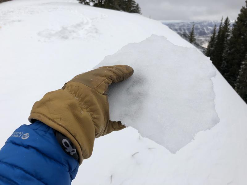
current conditions Mostly clear skies, and some filtered sun from high thin clouds are on tap for the day. It should be a beautiful day to be in the mountains, albeit - a little warm. Current temperatures are slightly inverted with many upper elevation thermometers in the upper twenties, while the lower elevation valleys and trail heads are in the upper teens °F. Ridgetop southerly winds are light, with speeds in the 5-10 mph range with the occasional gust. The snow surface has taken a hit the past couple of days. Yesterday's riming event has left a thin breakable crust on many aspects and elevations. The sunny slopes will have a melt freeze crust this morning that will soften with daytime heating. The best riding conditions exist on the wind and sun-sheltered slopes with general coverage of 50-70" of snow on the ground in the higher terrain. Photo: Rime crust found in Porter Fork in Millcreek Canyon by Greg Gagne.
|
 |
recent activity There was an avalanche triggered yesterday off the West Willow ridgeline, this is close to the Park City ridge line and can be found using this map. This avalanche was on an east facing slope at 9400' it was estimated as two feet deep and 60' feet wide running 400' feet into the flats. Nobody caught. It was reported that five other tracks and a skin track was already on the slope from yesterday. In the past week alone, we've had three very close calls in the central Wasatch - two along the Park City ridgeline (No Name and Pointy Peak) and Friday's accident just "right across the street" of Big Cottonwood Canyon in Silver Fork. Link to the accident report found HERE. These three persistent slab avalanches were all east to northeast facing between 9300' and 9600' with skiers taking rides hundreds of feet down the slope. Comprehensive list here. |
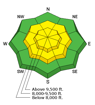
| type | aspect/elevation | characteristics |
|---|

|
|
LIKELIHOOD
 LIKELY
UNLIKELY
SIZE
 LARGE
SMALL
TREND
 INCREASING DANGER
SAME
DECREASING DANGER
|
|
description
Spooky, scary, eerie, weird, frightening, go ahead and pick your adjective that best describes the MODERATE danger for triggering a persistent slab avalanche. It continues to be a low probability for triggering an avalanche, but the consequence remain constant. Plenty of people have tested steep north through east facing slopes without triggering an avalanche. However, I continue to avoid the steep northerly terrain based on the consequences. Brian Lazar, a Colorado avalanche forecaster has a great write up, about why it's so hard to forecast this type of situation and has some great insights found HERE. Below is a video highlighting the type of avalanche you can still trigger. A few things really caught my attention after investigating this slide and is a personal reminder. 1. Notice the old tracks center punching the upper starting zone from the day before. Tracks are not an indicator of stability. 2. Never trust a faceted snowpack. 3. Choosing terrain with clean run-outs is a must. 4. Don't stand in run-out zones. 5. This avalanche was triggered from a distance in lower angled terrain. |
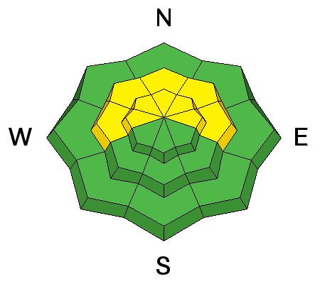
| type | aspect/elevation | characteristics |
|---|

|
|
LIKELIHOOD
LIKELY
UNLIKELY
SIZE
 LARGE
SMALL
TREND
 INCREASING DANGER
SAME
DECREASING DANGER
|
|
description
The National Weather Service releases a balloon every morning with a instrument called a radio sond attached to it. This instrument measures the temperatures in the atmosphere. Yesterday morning, this balloon measured the 700 millibar (10,000' foot) temperature at 19°F. This morning the same balloon measured it as 30°F. The temperature is expected to rise into the mid thirties today at 10,000'. This is a rapid warm up to our snowpack and you can expect loose wet activity today on the sunny slopes, especially in the afternoon. It's an easy problem to manage, when you start seeing roller balls cascading from the steeper terrain above, it's time to move around the compass to a shadier aspect. |
 |
weather High pressure, warming temperatures and filtered sunlight at times are expected today. Upper elevation temps will rise into mid thirties °F. Ridgetop winds will generally be from the south with speeds in the in the 5-15 mph range. Mild weather is expected for tomorrow with a dry cold front Tuesday night bringing cooler temperatures, and unfortunately, no chance of snow. Looking for snow? head to Canada (specifically Rogers Pass). |
| general announcements CLICK HERE FOR MORE GENERAL INFO AND FAQ The UAC has new support programs with Outdoor Research and Darn Tough. Support the UAC through your daily shopping. When you shop at Smith's, or online at Outdoor Research, REI, Backcountry.com, Darn Tough, Patagonia, NRS, Amazon, eBay a portion of your purchase will be donated to the FUAC. See our Donate Page for more details on how you can support the UAC when you shop. Benefit the Utah Avalanche Center when you buy or sell on eBay - set the Utah Avalanche Center as a favorite non-profit in your eBay account here and click on eBay gives when you buy or sell. You can choose to have your seller fees donated to the UAC, which doesn't cost you a penny This information does not apply to developed ski areas or highways where avalanche control is normally done. This advisory is from the U.S.D.A. Forest Service, which is solely responsible for its content. This advisory describes general avalanche conditions and local variations always occur. |