25th Annual Black Diamond Fall Fundraising Party
Thursday, September 13; 6:00-10:00 PM; Black Diamond Parking Lot
25th Annual Black Diamond Fall Fundraising Party
Thursday, September 13; 6:00-10:00 PM; Black Diamond Parking Lot
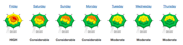
| Advisory: Salt Lake Area Mountains | Issued by Greg Gagne for Friday - January 19, 2018 - 5:13am |
|---|

|
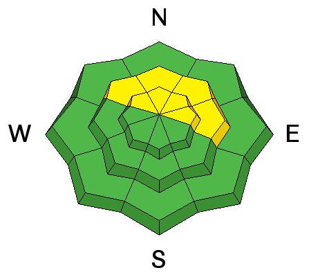
bottom line The avalanche danger is MODERATE on all mid and upper elevation slopes facing the north half of the compass west through east for triggering a persistent slab avalanche. Fresh wind drifts are also possible at the mid and upper elevations. Lower elevations and southerly facing slopes have a LOW danger. With a storm forecasted beginning later today, the avalanche hazard is expected to rise. Be sure to check Saturday's advisory before heading out.
|
 |
special announcement To get help in an emergency (to request a rescue) in the Wasatch, call 911. Be prepared to give your GPS coordinates or the run name. Dispatchers have a copy of the Wasatch Backcountry Ski map. If you trigger an avalanche in the backcountry, but no one is hurt and you do not need assistance, please notify the nearest ski area dispatch to avoid a needless response by rescue teams. Thanks.
|
 |
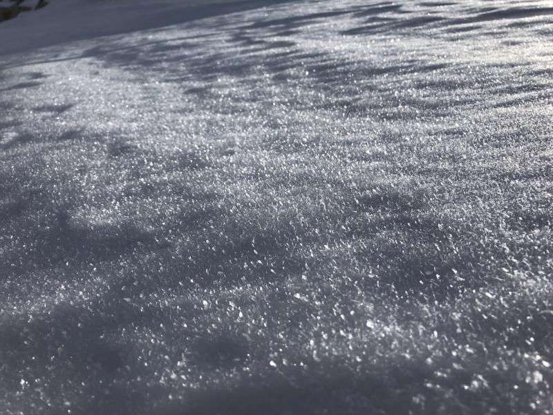
current conditions Warm and windy. Mountain temperatures range through the 30's F, with only the uppermost elevations dropping below freezing. Winds are the highlight - blowing out of the south/southwest, averaging in the teens and 20's mph. At the mid elevations, gusts are in the 20's and 30's mph, and gusting in the 50's mph at the upper elevations, with a few stations reporting overnight gusts in the 60's mph. Reading our Week in Review will be worthwhile as you are planning your weekend, especially with an approaching storm. Each Friday we summarize mountain weather and avalanche activity, as well as archived forecasts and danger roses, for the past week. Make it a regular part of your Fridays!
|
 |
recent activity No avalanches were reported from Thursday, and the last reported backcountry avalanche was this past Tuesday. However, during this last avalanche cycle, 8 people were caught in avalanches, with several close calls. Click HERE for a list of all reported avalanches in Utah. |
| type | aspect/elevation | characteristics |
|---|

|
|
LIKELIHOOD
 LIKELY
UNLIKELY
SIZE
 LARGE
SMALL
TREND
 INCREASING DANGER
SAME
DECREASING DANGER
|
|
description
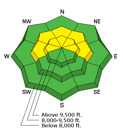
Weak, faceted snow plagues our snowpack on aspects facing west through east at the mid and upper elevations. The storm snow from Wednesday January 10 overloaded these weaknesses, leading to an avalanche cycle with avalanches reported through Tuesday January 16. Although the snowpack has shown signs of adjusting to last week's load, we have a storm on our doorstep, including strong pre-frontal winds. Persistent weaknesses follow the pattern of increasing avalanche hazard with any new load such as storm and/or wind-driven snow. Over time, the snowpack slowly adjusts, making avalanches harder (but still very much possible!) to trigger. With a new load, the hazard increases once again. With a storm forecasted beginning later today, I've highlighted with a red arrow where I am estimating the current avalanche hazard is with respect to our persistent weaknesses [image courtesy of Jay Gagne]:
Meet the new boss, same as the old boss. |
| type | aspect/elevation | characteristics |
|---|

|
|
LIKELIHOOD
LIKELY
UNLIKELY
SIZE
LARGE
SMALL
TREND
INCREASING DANGER
SAME
DECREASING DANGER
|
|
description
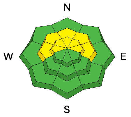
Although most solar aspects will be crusted and therefore should not provide much snow available for transport, there is plenty of soft snow on the shady aspects. Today's moderate to strong winds out of the south/southwest may find some of that snow and create fresh drifts at the mid and upper elevations. Although these drifts will likely be on leeward aspects, terrain may channel the wind creating drifts on a variety of aspects. Although I am not expecting these drifts to be large, they may be sensitive as they sitting on top of weaker snow. The good news about these winds (and warm temperatures) is they should help destroy faceted snow and surface hoar on our current snow surface.
|
 |
weather A desperately-needed storm is on its way! Mountain temperatures will rise into the 30's and low 40's F this morning, and drop this afternoon ahead of a cold front that should arrive in the Salt Lake mountains by the early evening hours. Increasing clouds with snow showers possible this afternoon. It will be blustery, with winds out of the south/southwest, averaging in the 20's and 30's mph, with gusts from 45-65 mph. OK, what we all really care about: Snowfall will pick up overnight, with 6-10" possible in the Cottonwoods by Saturday morning. Winds will rapidly diminish overnight, so the snow should fall straight out of the sky. A period of northwest flow later on Saturday should lead to additional snow with decreasing densities (aka right-side up storm). By the time it clears out later on Sunday, the Cottonwoods are likely to pick up 12-16", with the higher amounts in areas favored by a northwest flow. |
| general announcements CLICK HERE FOR MORE GENERAL INFO AND FAQ Support the UAC through your daily shopping. When you shop at Smith's, or online at REI, Backcountry.com, Patagonia, NRS, Amazon, eBay a portion of your purchase will be donated to the FUAC. See our Donate Page for more details on how you can support the UAC when you shop. Benefit the Utah Avalanche Center when you buy or sell on eBay - set the Utah Avalanche Center as a favorite non-profit in your eBay account here and click on eBay gives when you buy or sell. You can choose to have your seller fees donated to the UAC, which doesn't cost you a penny. This information does not apply to developed ski areas or highways where avalanche control is normally done. This advisory is from the U.S.D.A. Forest Service, which is solely responsible for its content. This advisory describes general avalanche conditions and local variations always occur. |