25th Annual Black Diamond Fall Fundraising Party
Thursday, September 13; 6:00-10:00 PM; Black Diamond Parking Lot
25th Annual Black Diamond Fall Fundraising Party
Thursday, September 13; 6:00-10:00 PM; Black Diamond Parking Lot
| Advisory: Salt Lake Area Mountains | Issued by Drew Hardesty for Sunday - January 14, 2018 - 5:54am |
|---|

|
bottom line We have a CONSIDERABLE avalanche danger on many slopes in the backcountry. The danger is real. Human triggered slides up to 3' deep are likely and may be triggered from below. The danger is most pronounced on steep northerly through easterly facing slopes at the mid and upper elevations. With direct sun and rapid warming, avoid overstaying your welcome on the steep sunny aspects for fear of unstable wet loose avalanching. If you're headed into the backcountry - or exiting though the gates at the ski area - you must have the proper gear, training, and skilled partners. Chance and hope are poor risk management strategies. PSA - Be aware of other parties in the backcountry - you would never would want to accidentally trigger a slide onto a party below - by remotely triggering a slide or kicking a cornice.
|
 |
special avalanche bulletin THE FOREST SERVICE UTAH AVALANCHE CENTER IN SALT LAKE CITY HAS ISSUED A BACKCOUNTRY AVALANCHE SPECIAL BULLETIN. * TIMING…IN EFFECT FROM 9 PM MST FRIDAY TO 9 PM MST MONDAY * AFFECTED AREA…FOR THE MOUNTAINS OF NORTHERN UTAH INCLUDING THE WASATCH RANGE...BEAR RIVER RANGE...UINTA MOUNTAINS. * AVALANCHE DANGER…DANGEROUS HUMAN TRIGGERED AVALANCHES REMAIN LIKELY. * IMPACTS…BEAUTIFUL WEATHER OVER THE HOLIDAY WEEKEND AND RECENT FRESH POWDER SNOW WILL LEAD TO A SIGNIFICANT INCREASE IN PUBLIC USE IN THE MOUNTAINS OF NORTHERN UTAH. SNOWPACK, WEATHER, AND HUMAN CONDITIONS ARE PERFECTLY ALIGNED FOR A POTENTIAL ACCIDENT THIS WEEKEND. MANY SLOPES, ESPECIALLY ONES ABOVE 8000 FT WITH A NORTHERLY THROUGH EASTERLY ASPECT, ONLY NEED A SKIER OR RIDER TO TRIGGER AN AVALANCHE 2-3 FEET DEEP AND SEVERAL HUNDRED FEET WIDE. THIS WARNING DOES NOT APPLY TO SKI AREAS WHERE AVALANCHE HAZARD REDUCTION MEASURES ARE PERFORMED. |
 |
special announcement To get help in an emergency (to request a rescue) in the Wasatch, call 911. Be prepared to give your GPS coordinates or the run name. Dispatchers have a copy of the Wasatch Backcountry Ski map. Backcountry Emergencies. It outlines your step-by-step method in the event of a winter backcountry incident. If you trigger an avalanche in the backcountry, but no one is hurt and you do not need assistance, please notify the nearest ski area dispatch to avoid a needless response by rescue teams. Thanks.
|
 |
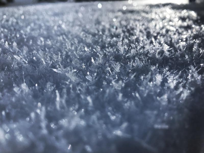
current conditions Skies are clear. Mountain temperatures are in the mid to upper 20s. Winds are northerly and generally less than 10mph. High relative humidity, light wind, and clear skies are perfect weather conditions for another bumper crop of surface hoar developing on the snow surfaces. It's the wintertime equivalent of dew; we call it "loud powder" and is fun to ski and ride through, but is problematic for the avalanche conditions once buried. (Bo Torrey pic below). The southerly aspects went off (became damp) yesterday, but the riding conditions remain quite good in the sun and wind sheltered terrain.
On another note, it sure seems like the future is now. High rain/snow lines from last Monday/Tuesday (up to 9000' give or take) and just looking around at the general coverage brings us to Leigh Sturges and John Horel's work in 2010, Assessing the sensitivity of Wasatch snowfall to temperature variations. (This was her master's work "while she was a pro observer for the UAC".) The image below from Steenburgh's Secrets of the Greatest Snow on Earth shows the work in a nutshell. Evelyn, too, well described the elevation-dependent snow years ago in an annual report - "It's as if a child had frosted a cake and had forgotten about the sides." Pic looking south along the Ogden skyline on Friday.
|
 |
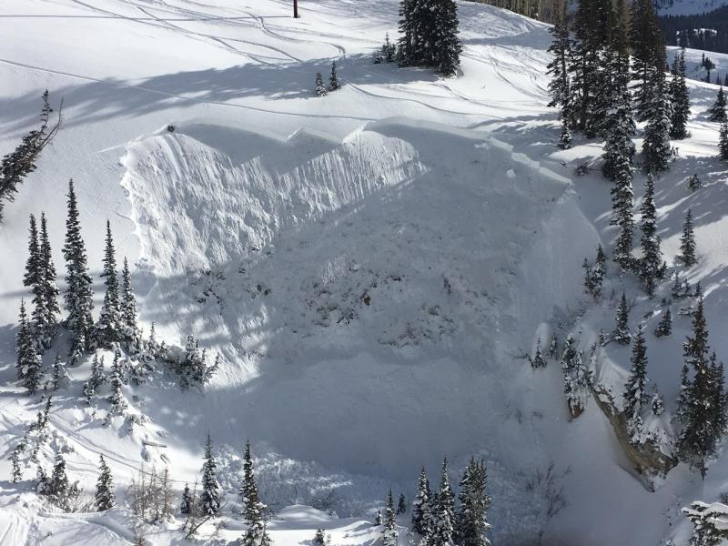
recent activity Yesterday's backcountry avalanche activity started off with a bang before 9am. We had two reports of unintentionally triggered slides (again thanks for the reports) in mid-elevation northerly terrain. The first two in Grizzly Gulch (pc: Trachtenberg)- 9200' northwest facing and the second in upper Snake Creek (9300' northeast facing) above Heber/Midway on the Wasatch backside (pc: Cracroft). Each of these were roughly 2-2.5' deep and 100' across. Each unintentionally triggered, the first from above, the second from below. If you look carefully, you'll note that the avalanche took out parts of the ski/snowmobile tracks. Other rumors filtered in of other human triggered slides in Pink Pine and Days Fork. We did hear of a very close call in the UIntas and hope to hear more about this today. I'm sure there were others.
Explosive control work continues to force the unreliable and mercurial snowpack's hand in the higher terrain. When new control work takes out old bed surfaces from previous control work, it makes us all step up and take note. |
| type | aspect/elevation | characteristics |
|---|

|
|
LIKELIHOOD
 LIKELY
UNLIKELY
SIZE
 LARGE
SMALL
TREND
 INCREASING DANGER
SAME
DECREASING DANGER
|
|
description
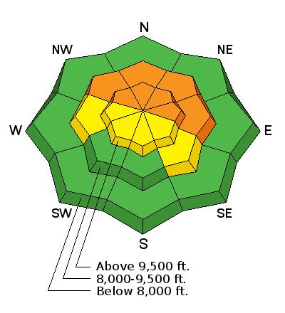
Conditions remain very dangerous in the backcountry. The likelihood of triggering some of these bone-snapping avalanches may be slightly less than the past few days and some snow tests are consistent with these conditions. Still, the consequences remain the same and the mind-tricks even more devilish. It's what the researcher Robin Hogarth describes as a "Wicked Environment" where x=y until it's z and z might be death. In backcountry terms, it means you might see put four tracks on a slope and your fifth track triggers the avalanche. While you're half-way down the slope and it's curtains. It's what makes these conditions so challenging. UAC observer Mark White describes it well in his report yesterday - "There was a uncomfortable lack of natural activity from the storm and many big N facing slopes are just waiting for a trigger, patience is key in this type of situation and the ankle deep snow makes low angle skiing fast and fun." Most people say that out of snowpack, weather, and terrain (and people), you can only choose the terrain. This is patently false. It's through terrain choices that one can choose their snowpack and their weather. (Good luck with the people choices.) What I mean by this is that if there's a dangerous part of town, then simply choose to not go there. That's the point of the aspect/elevation rose. So the choices are clear: 1 - avoid the rough part of town or 2 - go to the rough part of town and stay on low angle slopes with no overhead hazard or 3 - go to the rough part of town and roll the dice. |
 |
weather Bluebird high. Temps will rise to near freezing along the high ridgelines; wind will be light from the northwest. A weakening "sacrificial trough' moves through Tuesday afternoon to batter down the rebuilt ridge before a larger, colder, more hopeful Pacific winter storm engulfs the state on Friday. More info on our Mountain Weather page, updated by noon. |
| general announcements CLICK HERE FOR MORE GENERAL INFO AND FAQ Support the UAC through your daily shopping. When you shop at Smith's, or online at REI, Backcountry.com, Patagonia, NRS, Amazon, eBay a portion of your purchase will be donated to the FUAC. See our Donate Page for more details on how you can support the UAC when you shop. Benefit the Utah Avalanche Center when you buy or sell on eBay - set the Utah Avalanche Center as a favorite non-profit in your eBay account here and click on eBay gives when you buy or sell. You can choose to have your seller fees donated to the UAC, which doesn't cost you a penny. This information does not apply to developed ski areas or highways where avalanche control is normally done. This advisory is from the U.S.D.A. Forest Service, which is solely responsible for its content. This advisory describes general avalanche conditions and local variations always occur. |