25th Annual Black Diamond Fall Fundraising Party
Thursday, September 13; 6:00-10:00 PM; Black Diamond Parking Lot
25th Annual Black Diamond Fall Fundraising Party
Thursday, September 13; 6:00-10:00 PM; Black Diamond Parking Lot
| Advisory: Salt Lake Area Mountains | Issued by Evelyn Lees for Tuesday - December 26, 2017 - 6:26am |
|---|

|
bottom line AVALANCHE WARNING - The avalanche danger is HIGH today – backcountry travel in avalanche terrain is not recommended. Human triggered avalanches are likely on steep slopes facing northwest through southeasterly. Avalanches can be triggered remotely from a distance and from below. Avoid travel on and below all steep slopes, both the large obvious avalanche paths and smaller, steep gullies, creek beds and road banks at the lower elevations. Avoid avalanche terrain by heading to slopes less steep about 30 degrees, which are not adjacent to or below steeper terrain, such as meadows and rolling, low angle terrain.
|
 |
avalanche warning THE FOREST SERVICE UTAH AVALANCHE CENTER IN SALT LAKE CITY HAS CONTINUED THE BACKCOUNTRY AVALANCHE WARNING. * TIMING…IN EFFECT FROM 6 AM MST THIS MORNING TO 6 AM MST WEDNESDAY MORNING * AFFECTED AREA…FOR THE MOUNTAINS OF NORTHERN UTAH INCLUDING THE BEAR RIVER RANGE, WESTERN UINTAS, AND ALL THE WASATCH RANGE...THE OGDEN, PROVO, SALT LAKE AND PARK CITY AREA MOUNTAINS. * AVALANCHE DANGER…THE AVALANCHE DANGER FOR THE WARNING AREA IS HIGH TODAY. * IMPACTS…RECENT SNOW AND WIND HAS CREATED WIDESPREAD AREAS OF UNSTABLE SNOW. HUMAN TRIGGERED AVALANCHES ARE LIKELY. STAY OFF OF AND OUT FROM UNDER SLOPES STEEPER THAN 30 DEGREES. AVALANCHES CAN BE TRIGGERED REMOTELY FROM A DISTANCE AND FROM BELOW. THIS WARNING DOES NOT APPLY TO SKI AREAS WHERE AVALANCHE HAZARD REDUCTION MEASURES ARE PERFORMED. |
 |
special announcement Alta Ski Area is now open in the Supreme area. Alta is preforming avalanche work in this terrain. The area is closed to backcountry use. The Park City ski resort is doing control work in preparation for opening in Jupiter, McConkey's, 9990 and Condor areas. These areas are closed to backcountry use. Do you have all the gear you need? Check out the UAC’s online marketplace and auction for deals on resort passes, skis, packs, airbag packs, beacons, snowshoes, soft goods and much more. The auction closes at 6PM on December 28. |
 |
current conditions It’s been a good few days - since December 22 the Salt Lake, Park City and Ogden area mountains have received 1 ½ to 2 feet of snow, and closer to 30 inches since the December 20th. The mid elevations are starting to develop a more supportable snow pack, though it’s still shallow. Under partly cloudy skies, temperatures are in the teens to mid 20s this morning. Winds are from a westerly direction, averaging 5 to10 mph at the mid elevations, with average speeds up to 20 mph at the higher elevations. |
 |
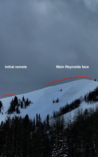
recent activity Yesterday, backcountry avalanche activity included slides triggered remotely from a distance on Reynolds Peak and a large slide triggered from below in Porter Fork. These broke on layers of weak, sugary faceted snow. Avalanche reduction work at the Cottonwood resorts resulted in many large avalanches from both explosives and ski cuts, some breaking mid-pack or to the ground. Many were running long distances and some of these were large enough to break a few trees. All elevations on the northerly facing slopes were active, including elevations below 9000 ft. Click HERE for recent Salt Lake and Park City area mountain observations. Upper photo: Reynolds Peak, Drew Hardesty photo Lower photo: Porter Fork, Bob Athey photo
|
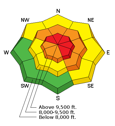
| type | aspect/elevation | characteristics |
|---|

|
|
LIKELIHOOD
 LIKELY
UNLIKELY
SIZE
 LARGE
SMALL
TREND
 INCREASING DANGER
SAME
DECREASING DANGER
|
|
description
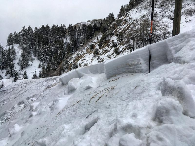
Collapsing, cracking and avalanches. Lots of avalanches. Avalanches yesterday were triggered from a distance and from below, breaking into the deeper faceted weak layers near the ground, large, dangerous and unpredictable. These weak faceted layers will be very slow to stabilize, and avoidance is key. The facets are most widespread on northwest through southeasterly facing slopes at the mid and upper elevations and on northerly facing slopes at the low elevations. Avoid travel on and below all steep slopes, including even the smaller, steep gullies, creek beds and road banks at the lower elevations. Upper: Mark White photo from 12/24 of a creek band slide at 7,200'. Lower: Drew Hardesty photo, marking a low elevation test slope that cracked out at 8,200', 12/25.
|
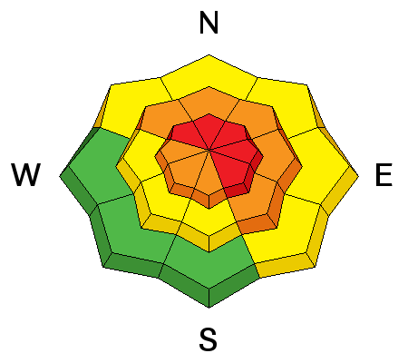
| type | aspect/elevation | characteristics |
|---|

|
|
LIKELIHOOD
 LIKELY
UNLIKELY
SIZE
 LARGE
SMALL
TREND
 INCREASING DANGER
SAME
DECREASING DANGER
|
|
description
While more stubborn, wind drifts could still be triggered on steep slopes today – most widespread along or just off ridgelines. Once any snow gets moving, it could step down to one of the deeper weak layers, resulting in a much larger avalanche. |
 |
weather We will be under a dry and mild west to northwest flow through the end of the week. Today, skies will be partly cloudy to sunny. Temperatures will be warm – reaching into the twenties to mid 30s today. Winds will mostly be light, in the 10 to 20 mph range, though the 11,000’ winds may gust into the 50 to 60 mph range at times. |
| general announcements FOR MORE GENERAL INFORMATION AND FAQ, CLICK HERE Support the UAC through your daily shopping. When you shop at Smith's, or online at REI, Backcountry.com, Patagonia, NRS, Amazon, eBay a portion of your purchase will be donated to the FUAC. See our Donate Page for more details on how you can support the UAC when you shop. Benefit the Utah Avalanche Center when you buy or sell on eBay - set the Utah Avalanche Center as a favorite non-profit in your eBay account here and click on eBay gives when you buy or sell. You can choose to have your seller fees donated to the UAC, which doesn't cost you a penny This information does not apply to developed ski areas or highways where avalanche control is normally done. This advisory is from the U.S.D.A. Forest Service, which is solely responsible for its content. This advisory describes general avalanche conditions and local variations always occur. |