25th Annual Black Diamond Fall Fundraising Party
Thursday, September 13; 6:00-10:00 PM; Black Diamond Parking Lot
25th Annual Black Diamond Fall Fundraising Party
Thursday, September 13; 6:00-10:00 PM; Black Diamond Parking Lot
| Advisory: Salt Lake Area Mountains | Issued by Mark Staples for Saturday - December 23, 2017 - 7:21am |
|---|

|
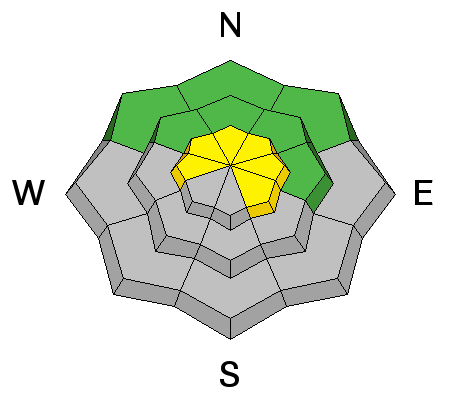
bottom line Today the avalanche danger is rising as snow is falling and winds are blowing. By later today the danger on upper elevation slopes should be CONSIDERABLE where fresh wind slabs will be easy to trigger. At mid elevations the danger will be MODERATE. Even on non wind affected terrain, persistent slab avalanches may be possible because the new snow is landing on such a weak snowpack.
|
 |
special announcement TONIGHT at Brighton in partnership with the Brighton Ski Patrol, we'll be giving a free avalanche awareness presentation focusing on why shallow snowpack winters, just like this year, are so dangerous. The talk begins a 5 p.m. in the Alpine Rose building on the 3rd floor. Do you have all the gear you need? Check out the UAC’s online marketplace and auction for deals on resort passes, skis, packs, airbag packs, beacons, snowshoes, soft goods and much more. The auction closes at 6PM on December 28. |
 |
current conditions As of 6 a.m. 8 inches of snow had fallen in upper Big Cottonwood Canyon and 5-6 inches in most other areas with more coming. Temperatures were in the upper teens and low 20s F. Winds at ridge tops were averaging 20 mph from the W with gusts of 30 mph. Above 10,000 feet wind gusts were reaching 40-50 mph. Low level, warm air kept valley locations south of Salt Lake City dry this morning despite snowfall in Bountiful and valley areas further north. The snowpack is still generally 1-2 feet deep, slighty deeper on high elevation northerly slopes and much shallower on south facing slopes. Many rocks are barely covered and remain a significant hazard. Week in Review > Saturday Dec 16 the Wasatch mountains picked up a trace to 2" of very low-density snow. > Quiet weather Sunday through Tuesday. > Strong south and southwest winds on Wednesday ushered in a cold front that arrived late Wednesday afternoon. Storm totals by Thursday included:
|
 |
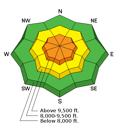
recent activity A few shallow wind slabs were triggered by ski patrollers in Big Cottonwood Canyon yesterday on North aspects at 9600 feet. These wind slabs were resting on weak, faceted snow and entrained faceted snow as they ran downhill. |
| type | aspect/elevation | characteristics |
|---|

|
|
LIKELIHOOD
 LIKELY
UNLIKELY
SIZE
 LARGE
SMALL
TREND
 INCREASING DANGER
SAME
DECREASING DANGER
|
|
description
Wind slabs yesterday were found mostly on westerly aspects. Today with mostly westerly winds, fresh wind slabs will exist mostly on easterly aspects. Sound confusing? It doesn't have to be, simply look for signs of wind loading and fresh wind slabs. With snowfall and winds continuing this morning into this afternoon, these wind slabs will be growing in size and becoming easier to trigger. |
| type | aspect/elevation | characteristics |
|---|

|
|
LIKELIHOOD
 LIKELY
UNLIKELY
SIZE
LARGE
SMALL
TREND
INCREASING DANGER
SAME
DECREASING DANGER
|
|
description
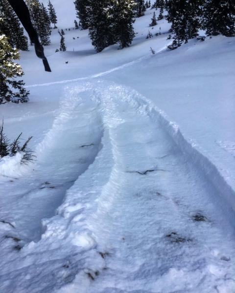
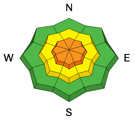
In general the snowpack on most slopes is very weak and faceted. This storm hasn't provided enough snow with enough weight to cause widespread persistent slab avalanches. As more snow accumulates later today, there should be enough new snow to cause smaller slides that break in layers of old, weak, faceted snow. The photo below shows the weak faceted snow that easily sluffed yesterday, and the new snow should easily sluff or make small persistent slab avalanches on these slopes. What to do? Unfortunately, if you want to ride in avalanche terrain, you'll have to do some homework by testing small slopes and digging quick snowpits. Assume that every slope has weak, faceted snow under the new snow. The harder question to answer is whether or not the new snow has added enough of a load and formed a slab to allow an avalanche to happen.
Photo - M. White |
 |
weather Snowfall will continue into this afternoon until a NW flow shuts off snowfall. Depending on the timing of the NW winds, an additional 6 inches of snow should fall or maybe more. Temperatures may only warm a few degrees into the mid 20s F. Winds should continue blowing 20 mph from the SW with 30-40 mph gusts and may ease some when they shift to the NW. |
| general announcements FOR MORE GENERAL INFORMATION AND FAQ, CLICK HERE Support the UAC through your daily shopping. When you shop at Smith's, or online at REI, Backcountry.com, Patagonia, NRS, Amazon, eBay a portion of your purchase will be donated to the FUAC. See our Donate Page for more details on how you can support the UAC when you shop. Benefit the Utah Avalanche Center when you buy or sell on eBay - set the Utah Avalanche Center as a favorite non-profit in your eBay account here and click on eBay gives when you buy or sell. You can choose to have your seller fees donated to the UAC, which doesn't cost you a penny This information does not apply to developed ski areas or highways where avalanche control is normally done. This advisory is from the U.S.D.A. Forest Service, which is solely responsible for its content. This advisory describes general avalanche conditions and local variations always occur. |