25th Annual Black Diamond Fall Fundraising Party
Thursday, September 13; 6:00-10:00 PM; Black Diamond Parking Lot
25th Annual Black Diamond Fall Fundraising Party
Thursday, September 13; 6:00-10:00 PM; Black Diamond Parking Lot
| Advisory: Salt Lake Area Mountains | Issued by Drew Hardesty for Tuesday - December 19, 2017 - 6:47am |
|---|

|
bottom line The avalanche danger is LOW – but small avalanches can be triggered in isolated areas or extreme terrain. The most likely avalanche would be a small, shallow wind drift at the highest elevations or shallow loose snow avalanche in steep shady terrain. The snow pack is very shallow - riding on lower angle, grassy slopes or sticking to snow packed roads will reduce the number of rocks and stumps you hit.
|
 |
special announcement Don’t know what to buy your favorite skier for Christmas? Discount lift tickets for Alta, Snowbird, Brighton, Solitude, Deer Valley, Snowbasin,and Beaver Mountain are now available, donated by the resorts to benefit the Utah Avalanche Center. Details and order information here. These make a great holiday gift and all proceeds go towards paying for avalanche forecasting and education! |
 |
current conditions Skies are clear with mountain temperatures in the low to mid- 20s. West to northwest winds blow 10-15mph with gusts to 25. Total snow on the ground on shady, upper elevation slopes is around 1 to 2 feet, and becoming less supportable in the shallower snowpack areas. Sunny slopes are a mix of crusty snow and bare ground, and there’s only patchy snow below 8,500’. View the latest observations here. |
 |
recent activity None. |
| type | aspect/elevation | characteristics |
|---|

|
|
LIKELIHOOD
 LIKELY
UNLIKELY
SIZE
 LARGE
SMALL
TREND
 INCREASING DANGER
SAME
DECREASING DANGER
|
|
description
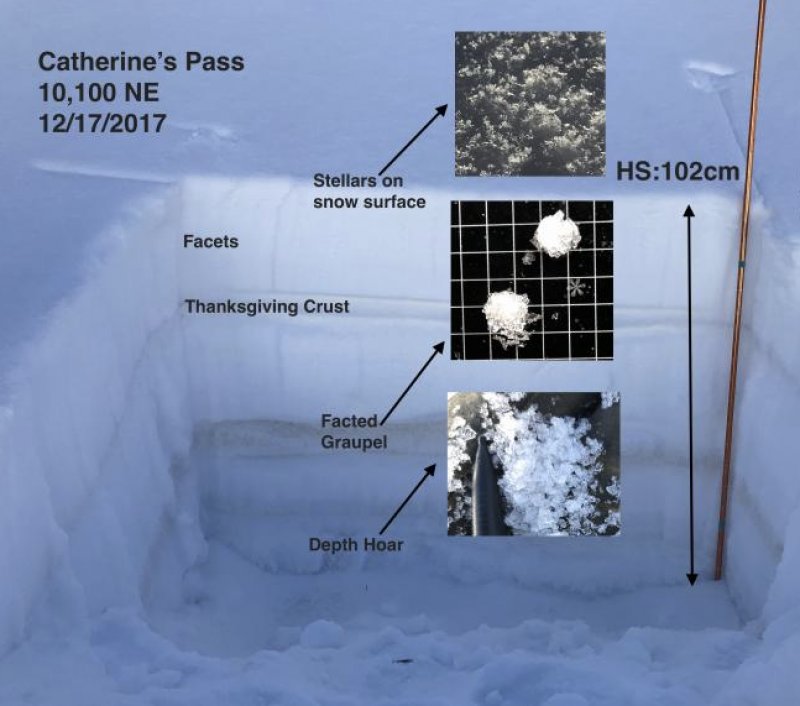
Though the avalanche danger is LOW, small avalanches can still be triggered in isolated places or extreme terrain. If you’re heading to the tops of the highest peaks today, watch for and avoid any shallow, new or old wind drifts, which could be cross-loaded onto a variety of aspects. The snowpack on the shady slopes consists of weak crusts and sugary faceted snow. This is a concern for the future when we finally get snow. For now, it’s amazing just to dig your hand into the snow and see how loose and weak it is. Tyler Falk has an excellent photo of the snowpack below. Below that, forecaster Greg Gagne (on the UAC Instagram page) keeps photos and notes for what lies ahead (put your cursor on Greg's pic and then look for the arrow on the right to scroll through his pics.)
|
 |
weather We'll have initially clear skies with building clouds in the early afternoon. Temperatures will be reaching near freezing along the ridgelines. Winds will be 15-20mph from the west. Strong southwest pre-frontal winds kick in later this afternoon, heralding an approaching cold front for through Wednesday midday. Expect 3-7" possible, though it'll be very low density - just enough to cover up, but not smooth over, the old ruts, crusts, and thinly buried obstacles. Mountain temps plummet to the low single digits on Thursday, with a colder, drier storm on tap for for Friday night. The fly in the ointment are the sustained upper end of moderate northerly winds that persist both after Wednesday's front and through the weekend. |
| general announcements FOR MORE GENERAL INFORMATION CLICK HERE This information does not apply to developed ski areas or highways where avalanche control is normally done. This advisory is from the U.S.D.A. Forest Service, which is solely responsible for its content. This advisory describes general avalanche conditions and local variations always occur. |