25th Annual Black Diamond Fall Fundraising Party
Thursday, September 13; 6:00-10:00 PM; Black Diamond Parking Lot
25th Annual Black Diamond Fall Fundraising Party
Thursday, September 13; 6:00-10:00 PM; Black Diamond Parking Lot
| Advisory: Salt Lake Area Mountains | Issued by Evelyn Lees for Sunday - December 17, 2017 - 6:55am |
|---|

|
bottom line The avalanche danger is LOW – but small avalanches can be triggered in isolated areas or extreme terrain. The most likely avalanche to trigger would be a small, shallow wind drift at the highest elevations. The snow pack is very shallow - riding on lower angle, grassy slopes or sticking to snow packed roads will reduce the number of rocks and stumps you hit.
|
 |
special announcement With no change in conditions expected or any storms on the horizon, we will be issuing intermittent advisories. The next update will be Monday the 18th of December. Check out the blog Avalanche Fatalities During Uphill Travel. Backcountry travelers need a clear focus on evaluating terrain during their ascent, as well as their descents. |
 |
current conditions The splitting trough was another bust, leaving behind less than an inch of snow at most mountain locations. Winds have shifted to the north, and are forecast to be light. Temperatures in mountains should be in the low teens to singlle digits this morning. Total snow on the ground on shady, upper elevation slopes is around 1 to 2 feet, and becoming less supportable in the shallower snowpack areas. Sunny slopes are a mix of crusty snow and bare ground, and there’s only patchy snow below 8,500’. View the latest observations here. |
 |
recent activity No new avalanche activity has been reported for over a week. |
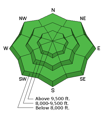
| type | aspect/elevation | characteristics |
|---|

|
|
LIKELIHOOD
 LIKELY
UNLIKELY
SIZE
 LARGE
SMALL
TREND
 INCREASING DANGER
SAME
DECREASING DANGER
|
|
description
Though the avalanche danger is LOW, small avalanches can still be triggered in isolated places or extreme terrain. If you’re heading to the tops of the highest peaks today, also watch for and avoid any shallow, new or old wind drifts, which could be cross-loaded onto a variety of aspects. The snowpack on the shady slopes consists of weak crusts and sugary faceted snow. This is a concern for the future when we finally get snow. For now, it’s amazing just to dig your hand into the snow and see how loose and weak it is. |
 |
weather High pressure will once again dominate through about Tuesday, with a warming trend. Highs will once again warm into the 30s and then 40s. Winds will remain very light from the north on Sunday. On the plus side, there is a small storm in the forecast for late Wednesday into Thursday, and maybe another for next weekend. |
general announcements
|


